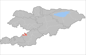
Aravan District
| Aravan | |
|---|---|
| Raion | |
 | |
| Country | Kyrgyzstan |
| Region | Osh Region |
| Area | |
| • Total | 520 sq mi (1,340 km2) |
| Population (2009)[1] | |
| • Total | 106,134 |
| • Density | 210/sq mi (79/km2) |
| Time zone | GMT +5 (UTC+5) |
Aravan is a raion (district) of Osh Region in south-western Kyrgyzstan. The capital lies at Aravan.
Aravan district's area is 1,340 km.sq, making it the smallest district in Osh Region:[2]
Demographics
As of 2009, Aravan District contained 48 villages. Its population, according to the Population and Housing Census of 2009, was 106,134.
| Historical populations in Aravan District | ||
|---|---|---|
| Year | Pop. | ±% |
| 1970 | 43,894 | — |
| 1979 | 53,220 | +21.2% |
| 1989 | 71,214 | +33.8% |
| 1999 | 91,438 | +28.4% |
| 2009 | 106,134 | +16.1% |
| Note: de jure population; Source:[1] | ||
Ethnic composition
According to the 2009 Census, the ethnic composition of the Aravan District (de jure population) was:[1]
| Ethnic group | Population | Proportion of Aravan District population |
|---|---|---|
| Uzbeks | 62,281 | 58.7% |
| Kyrgyzs | 42,049 | 39.6% |
| Azerbaijanis | 760 | 0.7% |
| Tajiks | 542 | 0.5% |
| Tatars | 135 | 0.1% |
| other groups | 367 | 0.4% |
Towns, rural communities, and villages
In total, Aravan District include 8 rural communities (aiyl okmotus). Each rural community can consist of one or several villages. The rural communities in Aravan District are:[3]
- Аllya Anarov (rus:Анаров, Алля) aiyl okmotu (center - village Jany-Aravan, and also villages Aravan, Achchi, Kara-Bulak, Sasyk-Ukyur)
- A.Yusupov ayil okmotu (center - village Aravan, and also villages Karak, Oktyabr', Irke-Kashka, Sutkor)
- Chekabad ayil okmotu (center - village Kochubaevo, and also villages Agronom, Jakshylyk, Shur-Kishlak, Kukalapash, Maksim-Tobu, Pahtachi, Teleyken)
- Kerme-Too ayil okmotu (center - village Gyul'bakhor, and also villages Kichik-Alay, Kyundelyuk, Maydan-Tal, Min-Teke, Sary-Bulak, Tokom)
- Mangyt ayil okmotu (center - village Mangit and also villages Kesek, Kyzyl-Korgon, Teleyken, Jany-Aryk)
- Nur-Abad ayil okmotu (center - village Kayragach-Aryk, and also villages Kakyr-Piltan, Langar)
- Tepe-Korgon ayil okmotu (center - village Tepe-Korgon, and also villages Arap, Internatsional, Kesov, Uygur-Abad, Chertik, Yangi-Abad, Yangi-Yl)
- Tuya-Moyun ayil okmotu (center - village Hauz, and also villages Akshor, Jeke-Miste, Kerkidan, Nayman, Sary-Tash, Syrt)
References
- 1 2 3 Population and Housing Census 2009. Book 3 (in tables). Regions of Kyrgyzstan: Osh Region (Перепись населения и жилищного фонда Кыргызской Республики 2009. Книга 3 (в таблицах). Регионы Кыргызстана: Ошская область (PDF), Bishkek: National Committee on Statistics, 2010
- ↑ Enrin.grida.no
- ↑ List of Rural Communities of Kyrgyzstan
Capital: Bishkek (also four raions: Lenin, Oktyabr, Pervomay, Sverdlov) | ||
| Batken Region | 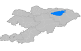 | |
| Chuy Region | ||
| Issyk Kul Region | ||
| Jalal-Abad Region | ||
| Naryn Region | ||
| Osh Region | ||
| Talas Region | ||
Coordinates: 40°30′54″N 72°29′55″E / 40.5151°N 72.4986°E
This article is issued from Wikipedia - version of the 5/6/2016. The text is available under the Creative Commons Attribution/Share Alike but additional terms may apply for the media files.