Booterstown
| Booterstown Baile an Bhóthair | |
|---|---|
| Suburb of Dublin | |
 Booterstown Location in Ireland | |
| Coordinates: 53°18′31″N 6°11′47″W / 53.3087°N 6.1964°WCoordinates: 53°18′31″N 6°11′47″W / 53.3087°N 6.1964°W | |
| Country | Ireland |
| Province | Leinster |
| County | Dún Laoghaire–Rathdown |
| Government | |
| • Dáil Éireann | Dún Laoghaire |
| Population (2006) | |
| • Urban | 2,975 |
| Time zone | WET (UTC+0) |
| • Summer (DST) | IST (WEST) (UTC-1) |
| Area code(s) | 01, +353 1 |
| Irish Grid Reference | O201304 |


Booterstown (Irish: Baile an Bhóthair, meaning "town of the road") is a coastal townland and civil parish, situated in the county of Dún Laoghaire–Rathdown, about 7 km (4.3 mi) south of the city of Dublin in Ireland.
Location and access
Its neighbouring areas are Sandymount to the north and Blackrock to the south, while along the coast to the south-east is the small district of Williamstown.
Transport
Booterstown is served by the DART, with a railway station between the stops of Blackrock and Sydney Parade. Booterstown railway station opened in January 1835.[1] Booterstown is also served by two Quality Bus Corridors, Stillorgan and Blackrock, Dublin.[2] A frequent Aircoach service links the area with Dublin Airport.
History

Historically known in English as Ballyboother[3][4] the name "Booterstown" is an anglicised form of the original Irish name Baile an Bhóthair, meaning "The Town of the Road". In its original Irish form it shares the same name as Batterstown in County Meath, as well as Ballinvoher in Kilkenny, Cork, Kerry, Limerick, Longford and Mayo.[5]
Booterstown lies along an ancient route once known as Slíghe Chualann, which connected the residence of the High King of Ireland at Tara with his outlying lands in Cualann. Cualann is the ancient name for the area of land stretching towards Bray (Irish: Brí Chualann).[6]
The Congregation of the Irish Christian Brothers had their headquarters at St. Helen's, Booterstown from 1925 to 1988. St. Helen's was built in 1760 for Thomas Cooley, MP and was known originally as Seamount. It was extensively refurbished a century later while in the ownership of Viscount Gough, Field Marshal of the British Army, whose wife Marie Frances opened the gardens to the public. The house is now a hotel of The Radisson Group.
Booterstown still retains its link with the name Tara, as the Tara Towers hotel was built there in the 1970s and is still a landmark today on the Merrion Road, next to the historical Bellevue Merrion Cemetery.
Booterstown today
Features
The area is home to Booterstown marsh, a well-known bird sanctuary which has been leased for many years by An Taisce, who have worked to protect it.[7] Species seen regularly include mallard, teal, moorhen, water rail, grey heron, little egret, redshank, greenshank, curlew, snipe, oystercatcher, bar-tailed godwit, kingfisher, sedge warbler and dunlin.
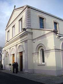
The Catholic Church of the Assumption is a focal point of the area along Booterstown Avenue.
Booterstown has a dedicated Circus Field located along the Rock Road, where both Duffy's Circus (June/July) and Fossett's Circus (October) set up once a year.[8]
The Old Punch Bowl pub, which stands at the bottom of Booterstown Avenue, was established in 1779.
Merrion Cemetery is an old cemetery that was used from the 13th century to 1866 and is located at Bellevue between Booterstown and Merrion off the Rock Road.
Booterstown was recorded in 1488 as one of the locations for the boundary of The Pale.[9]
Education
Primary schools
There are many schools in the area.
- Booterstown National School, Cross Avenue
- Our Lady of Mercy Girls School, Booterstown
- St. Andrew's College, Booterstown
- St. Mary's Boys National School, Booterstown
- Willow Park School, Booterstown
Secondary schools
There are two Gaelscoileanna: Coláiste Eoin and Coláiste Íosagáin. It is also home to St. Andrew's College, which moved here from Clyde Road in 1973.
- Blackrock College, Rock Road
- Colaiste Eoin, Stillorgan Road
- Colaiste Iosagain, Stillorgan Road
- Dominican College Sion Hill, Cross Avenue
- St. Andrew's College, Booterstown
Churches
- Church of the Assumption, Booterstown (Roman Catholic)
- South Hill Evangelical Church, Booterstown (Evangelical)
- St. Andrew's, Mount Merrion Avenue (Presbyterian)
- St. Philip and St. James Church, Cross Avenue (Church of Ireland)
Notable people
- Hugh Carleton, 1st Viscount Carleton was an eminent judge and at one time an owner of Willow Park.
- William Downes, 1st Baron Downes, Lord Chief Justice of Ireland, had a house called Merville in Booterstown, and died there in 1826.
- Maziere Brady, Lord Chancellor of Ireland for almost 20 years was a native of Booterstown. His family owned what is now Willow Park School.
- Richard Robert Madden lived at 4 Booterstown Avenue (a plaque is noted here) and on Vernon Terrace. He was an Irish doctor, writer, abolitionist and historian of the United Irishmen.[8]
- Francis Elrington Ball lived at Booterstown House at one time. He was an Irish author and legal historian, best known for his work The Judges in Ireland 1221-1921 and A history of the county of Dublin (Parts 1-6).[8]
- Eoin MacNeill lived on South Hill Avenue, Booterstown. He was an Irish scholar, nationalist, revolutionary and politician.[8]
- John McCormack lived in Booterstown for a short while in "Glena", a fine house overlooking the sea opposite the Booterstown Marsh. He died there in 1945.[8]
- Kevin O'Higgins lived in a house called "Dunamase" and was the Minister for Justice in the Government of the Irish Free State. He was assassinated on the Booterstown end of Cross Avenue on his way to mass at the local parish church, Church of the Assumption, on 10 July 1927 by members of the IRA. It is believed that he was assassinated for ordering the execution of seventy-seven republicans during his tenure in office.[8][10]
- Seán MacBride lived in Booterstown. He was an Irish government minister and prominent international politician. In his early life, while he was a member of the IRA, he was charged with the murder of Kevin O'Higgins in 1927.[11]
- Maurice Neligan was an Irish heart surgeon born in Booterstown noted for carrying out Ireland's first coronary artery bypass graft in 1975, Ireland's first heart transplant in 1985 and an estimated 15,000 open heart surgery operations, many on children. He was also a founder of the nearby Blackrock Clinic.[12]
- Kenny Carroll was born in Booterstown and is an Irish cricketer.
- Simon Watson was born in Booterstown and is an Irish portrait, interior, and travel photographer.
See also
External links
| Wikimedia Commons has media related to Booterstown. |
References
- ↑ "Booterstown station" (PDF). Railscot – Irish Railways. Retrieved 2007-08-31.
- ↑ "Dublin Bus QBC Report". QBC Monitoring Report. Retrieved 2009-04-06.
- ↑ Google Books, The History of the county of Dublin
- ↑ Placenames Database of Ireland
- ↑ http://logainm.ie/Viewer.aspx?text=Baile+an+Bh%C3%B3thair&streets=yes 'Baile an Bhóthair', Logainm.ie
- ↑ Pearson, P (2001). "Between the Mountains and the Sea" Dún Laoghaire Rathdown County, The O'Brien Press ISBN 978-0-86278-977-0
- ↑ Birdweb item on Friends of Booterstown marsh Archived August 14, 2006, at the Wayback Machine.
- 1 2 3 4 5 6 Tom Roche and Ken Finlay (2003). "Blackrock, Dun Laoghaire and Dalkey (Along the coast from Booterstown to Killiney)" Cottage Publications ISBN 1-900935-34-1
- ↑ John D'Alton,The History of the County of Dublin (Dublin, 1838), p. 34.
- ↑ Lyng, Paul (2000). "Booterstown, A pastoral journey through four centuries 1616-2000" Future Print
- ↑ Jordan, Anthony J. (1993). "Seán MacBride: A Biography." Dublin: Blackwater Press. p47. ISBN 0-86121-453-6
- ↑ Lavery, Don (10 October 2010). "Tributes pour in for life-saving 'maverick' Neligan". Irish Independent. Dublin: Independent News & Media. Retrieved 13 January 2012.