Wanneroo Road
| Wanneroo Road Western Australia | |
|---|---|
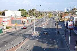 | |
| Looking south, towards Perth in Tuart Hill | |
| General information | |
| Type | Highway |
| Length | 44 km (27 mi) |
| Opened | 1920s |
| Route number(s) |
|
| Major junctions | |
| South end |
|
| |
| North end |
|
| Location(s) | |
| Major suburbs | Tuart Hill, Wanneroo, Yanchep |
| Highway system | |
|
Highways in Australia National Highway • Freeways in Australia Highways in Western Australia | |
| |
Wanneroo Road is a 44 kilometre arterial highway in the northern suburbs of Perth, Western Australia, linking Joondanna and Yokine in the south with Wanneroo and Yanchep in the north. As part of State Route 60, it begins from Charles Street in the inner city and becomes Indian Ocean Drive up to Dongara.
Originally a narrow and often country road with a single lane in each direction it has been periodically widened and (particularly north of Wanneroo) straightened. Around the Carabooda area the road has been realigned. Short sections of the original, narrow road remain providing access to properties and businesses along the road.
The road is also multiplexed with State Routes 81 and 83 for short lengths.
History
After the enactment of the Road Districts Act 1871, the Perth Road Board requested that the Legislative Council proclaim eight public thoroughfares through its territory,[1] and on 4 June 1872, Road No.3, intended as a route from Perth to Champion Bay (now Geraldton) via Wanneroo, was published in the Government Gazette.[2] However, the act of proclaiming the road was not contiguous with its development, and progress on surfacing the track occurred at a slow rate.
A proposal to rename the road as "Yanchep Highway" was made in November 1940.[3] The Perth Road Board (now City of Stirling) was in favour of the proposal, subject to the Wanneroo Road Board (now City of Wanneroo) renaming their portion of Wanneroo Road,[3] but the Wanneroo Road Board indicated that they would support a name change if it included Charles Street, in the Perth City Council area.[4] There was no agreement reached.
In 2008, the intersection with Ocean Reef Road (SR84) was upgraded. A second left turn lane was added for drivers entering Ocean Reef Road westbound from Wanneroo Road from the North, a second right turn lane to enter Ocean Reef Road westbound, and a second left and right turn lane at Ocean Reef Road (westbound).
In 2010 Wanneroo Road was duplicated from Wallawa Street to Joondalup Drive.
In 2013, traffic lights were installed at Hester Avenue and widened.
Major intersections
All major intersections south of and including Hester Avenue are controlled by traffic lights.
-
 London Street (State Route 61) – to Mount Hawthorn, Leederville.
 -
 Morley Drive (State Route 76) – to Dianella, Yokine, Morley, Nollamara, Stirling, Innaloo.
 - Main Street – to Balcatta, Tuart Hill, Osborne Park.
-
 Balcatta Road (State Route 78) – to Balcatta.
 -
 Reid Highway (State Route 3) - to Mirrabooka, Malaga, Beechboro, Carine.
 - Beach Road – to Girrawheen, Balga, Koondoola, Mirrabooka, Warwick, Hamersley, Carine, Duncraig.
-
 Warwick Road (State Route 81) – to Warwick, Greenwood, Duncraig.
 - Marangaroo Drive (State Route 81) – to Marangaroo, Girrawheen, Alexander Heights, Koondoola, Ballajura.
-
 Hepburn Avenue (State Route 82) – to Marangaroo, Madeley, Darch, Kingsley, Greenwood, Duncraig, Padbury.
 -
 Gnangara Road (State Route 83) – to Madeley, Wangara, Landsdale, Gnangara, Ellenbrook, Henley Brook.
 - Whitfords Avenue (State Route 83) – to Woodvale, Kingsley, Padbury, Craigie.
-
 Ocean Reef Road (State Route 84) – to Wangara, Pearsall, Woodvale, Edgewater, Beldon, Heathridge.
 - Dundebar Road – to Wanneroo, Sinagra.
- Pinjar Road – to Ashby, Tapping, Mariginiup, Banksia Grove.
-
 Joondalup Drive (State Route 85) – to Joondalup, Edgewater, Burns Beach, Carramar, Tapping, Banksia Grove.
 - Hester Avenue – to Clarkson, Ridgewood, Merriwa, Mindarie.
- Yanchep Beach Road – to Yanchep.
Gallery
| Wikimedia Commons has media related to Wanneroo Road. |
 Looking south near Balcatta Road (9 km)
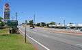
 Looking south near Hester Avenue (34 km)
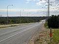 Looking north near One Tree Hill (36 km)
.ogv.jpg) View southbound from Warwick Road
View southbound from Warwick Road
See also
References
- ↑ Cooper, W.S.; G. McDonald (1999). Diversity's Challenge: A History of the City of Stirling. City of Stirling. p. 82.
- ↑ "Major Roads". Western Australia Government Gazette. 4 June 1872. p. 1872:126.
- 1 2 ""YANCHEP-HIGHWAY.".". The West Australian. Perth: National Library of Australia. 21 November 1940. p. 4. Retrieved 27 November 2012.
- ↑ "PROPOSED YANCHEP HIGHWAY.". The West Australian. Perth: National Library of Australia. 14 February 1941. p. 4. Retrieved 27 November 2012.
Road infrastructure in Western Australia | ||
|---|---|---|
| Freeways | ||
| Metropolitan highways | ||
| Highways and major roads |
| |
| Outback tracks | ||
| ||||||||
| National Highways | ||||||||
| National Routes | ||||||||
| State Routes | ||||||||
| Tourist Drives | ||||||||