South Coast Highway
| South Coast Highway Western Australia | |
|---|---|
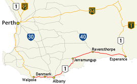 | |
| Map of south-west Western Australia with South Coast Highway highlighted in red | |
| General information | |
| Type | Highway |
| Length | 592 km (368 mi) |
| Route number(s) |
|
| Major junctions | |
| West end |
|
| |
| East end |
|
| Location(s) | |
| Major settlements | Albany, Manypeaks, Jerramungup, Ravensthorpe |
| Highway system | |
|
Highways in Australia National Highway • Freeways in Australia Highways in Western Australia | |
| |
South Coast Highway is a Western Australian highway. It is a part of the Highway 1 network.[1]
With a length of 592 kilometres (368 mi), it runs from Esperance to Walpole roughly in parallel to Western Australia's south coast. Even then the journey is pretty much inland.
Approximately 40 kilometres from Ravensthorpe lies the Fitzgerald River National Park with beaches, coastal and mountain walking trails and wildflowers. There are three more national parks with abundant wildlife along the journey to Walpole. Albany is a former whaling town and is rich in history.
Beyond Walpole, Highway 1 continues as South Western Highway to Perth. Beyond Esperance, Highway 1 continues as Coolgardie–Esperance Highway to Norseman.
Towns
See also
![]() Australian Roads portal
Australian Roads portal
References
- ↑ Distance book (12 ed.). Main Roads Western Australia. 2012. pp. 4–5. ISBN 0 7309 7657 2. Retrieved 8 October 2012.
External links
![]() South Coast Highway travel guide from Wikivoyage
South Coast Highway travel guide from Wikivoyage
Road infrastructure in Western Australia | ||
|---|---|---|
| Freeways | ||
| Metropolitan highways | ||
| Highways and major roads |
| |
| Outback tracks | ||
| ||||
| National Highways | ||||
| National Routes | ||||
| State Routes | ||||
| Tourist Drives | ||||