Muirs Highway
| Muirs Highway Western Australia | |
|---|---|
| General information | |
| Type | Highway |
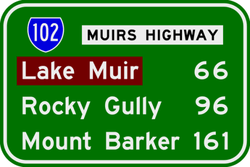
| Length | 161 km (100 mi) |
| Route number(s) |
|
| Major junctions | |
| West end |
|
| |
| East end |
|
| Location(s) | |
| Major settlements | Lake Muir, Rocky Gully |
| Highway system | |
|
Highways in Australia National Highway • Freeways in Australia Highways in Western Australia | |
| |
Muirs Highway is a Western Australian highway linking Manjimup and Mount Barker on the Albany Highway. It is signed as State Route 102[1] and is 161 kilometres (100 mi) long. It provides a shorter distance between Manjimup and Albany. It is a lonely highway surrounded with karri and jarrah forests with no settlements in between except the small farming settlement of Rocky Gully.
See also
![]() Australian Roads portal
Australian Roads portal
References
- ↑ South West Region map (PDF) (PDF). Version 1.0. Cartography by Main Roads Western Australia. Main Roads Western Australia. 13 August 2013. Archived from the original on 29 August 2013. Retrieved 28 December 2012.
Road infrastructure in Western Australia | ||
|---|---|---|
| Freeways | ||
| Metropolitan highways | ||
| Highways and major roads |
| |
| Outback tracks | ||
Coordinates: 34°22′59″S 116°27′01″E / 34.38311°S 116.45027°E
This article is issued from Wikipedia - version of the 5/13/2016. The text is available under the Creative Commons Attribution/Share Alike but additional terms may apply for the media files.