Canning Highway
| Canning Highway Western Australia | |
|---|---|
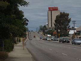 | |
| Canning Highway running through Kensington/South Perth | |
| General information | |
| Type | Highway |
| Length | 17 km (11 mi) |
| Opened | 1920s |
| Route number(s) |
|
| Major junctions | |
| Northeast end |
|
| |
| Southwest end |
|
| Location(s) | |
| Major settlements | South Perth, Kensington, Como, Applecross, East Fremantle |
| Highway system | |
|
Highways in Australia National Highway • Freeways in Australia Highways in Western Australia | |
| |
Canning Highway is a 17 kilometre arterial road in Perth, Western Australia, linking the inner Perth suburb of Victoria Park in the north-east, to the port city of Fremantle in the south-west.
The road is mostly a four-lane divided carriageway, with a general speed limit of 60 km/h. It is located immediately south of the Swan River and runs between The Causeway in Victoria Park and Queen Victoria Street in Fremantle.
History
Canning Highway is named after the river which it crosses,[1] which was in turn named after George Canning (1770–1827), an eminent British statesman who for a brief period was Prime Minister of Great Britain.
The modern highway was formally commenced in the 1920s, with major work commencing in 1927 to upgrade an 8-mile (13 km) section between Suburban Street, South Perth and Petra Street, East Fremantle. The road initially had the following names:[2]
- Canning Road (Fremantle–Wireless Hill)
- Perth–Fremantle Road (Wireless Hill–Canning Bridge)
- Lower Canning Road (Canning Bridge–South Terrace)
- Fremantle Road (South Terrace–Causeway)
The road was officially named Canning Highway on 23 November 1937.[2] In 1938, the present northern bridge over Canning River was opened. It was 32 feet (9.8 m) wide and constructed of timber, as was then common practice. The experience gained building this bridge was used to construct the Fremantle Traffic Bridge over the Swan River one year later. The Fremantle Traffic Bridge joined Canning Highway near Fremantle with North Fremantle, and this intersection forms the highway's present western terminus.
In 1958, the present southern bridge over Canning River was constructed which coincided with the opening of Kwinana Freeway between the Narrows Bridge and Canning Highway.
In 1974, the rotary (roundabout) at the southern end of the Causeway in Victoria Park was upgraded to a parclo interchange, which resulted in Canning Highway joining seamlessly with Great Eastern Highway. At the same time, Stirling Highway was extended from North Fremantle across the Swan River via the new Stirling bridge to join with Canning Highway.
In 1979, a new diamond interchange was built near Canning Bridge to route the Kwinana Freeway underneath Canning Highway and progress the freeway further southwards.
Apart from minor additional lanes and modifications, the highway has remained largely unchanged since.
Raffles Hotel
One of the most enduring sights on Canning Highway has been the Raffles Hotel at night-time, with its ornamental lighting and an iconic animated rooftop neon beer sign (for many years advertising Swan Lager). It is situated in Applecross adjacent to Canning Bridge. The hotel has reopened with a pub and a bottle shop called Raffles Liquor Merchants. The Raffles now has two beer advertising neon lights, one for Victoria bitter and one large one advertising Crown lager.
Along with the Canning Highway, the Raffles Hotel was the inspiration for the AC/DC song Highway to Hell because of the reputation that the Raffles Hotel had in the 1970s of being a popular Rock 'N' Roll hideout, where young teenagers would go and see bands and sometimes end up getting killed at the bottom of a crossroads just next to the hotel, earning it the nickname the "Highway To Hell".
Public transport
Canning Highway crosses the Kwinana Freeway at the Canning Bridge station on the Mandurah railway line. Buses also stop at this station and enter and exit the freeway via bus lanes.
| Wikimedia Commons has media related to Canning Highway. |
See also
- Highways in Australia
- List of highways in Western Australia
- List of major roads in Perth, Western Australia
References
- ↑ "Origin and Meaning of Street and Place Names" (PDF). Municipal Heritage Inventory. City of South Perth. July 2004. p. 17. Retrieved 11 March 2013.
- 1 2 "The Land Act, 1933–1936. Change of Name of Road — Perth to Fremantle. (per 1495/30)". Western Australia Government Gazette. 23 November 1937. p. 1937:2009.
- Edmonds, Leigh (1997). The vital link: a history of Main Roads Western Australia 1926–1996. Nedlands, Western Australia: University of Western Australia Press. ISBN 1-875560-87-4.
- StreetSmart Perth 2003 Street Directory. Midland, Western Australia: Department of Land Administration and West Australian Newspapers Ltd. 2002. ISBN 0-909699-87-9.
External links
Road infrastructure in Western Australia | ||
|---|---|---|
| Freeways | ||
| Metropolitan highways | ||
| Highways and major roads |
| |
| Outback tracks | ||
| ||||||
| National Highways | ||||||
| National Routes | ||||||
| State Routes | ||||||
| Tourist Drives | ||||||