Vou
| Vou | |
|---|---|
|
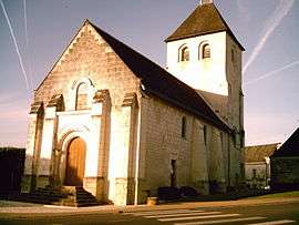
The church of Saint Pierre, in Vou | |
 Vou | |
|
Location within Centre-Val de Loire region  Vou | |
| Coordinates: 47°05′10″N 0°51′37″E / 47.0861°N 0.8603°ECoordinates: 47°05′10″N 0°51′37″E / 47.0861°N 0.8603°E | |
| Country | France |
| Region | Centre-Val de Loire |
| Department | Indre-et-Loire |
| Arrondissement | Loches |
| Canton | Descartes |
| Government | |
| • Mayor (2001–2008) | Jean-Maurice Grandchamp |
| Area1 | 21.95 km2 (8.47 sq mi) |
| Population (2009)2 | 215 |
| • Density | 9.8/km2 (25/sq mi) |
| Time zone | CET (UTC+1) |
| • Summer (DST) | CEST (UTC+2) |
| INSEE/Postal code | 37280 / 37240 |
| Elevation | 81–134 m (266–440 ft) |
|
1 French Land Register data, which excludes lakes, ponds, glaciers > 1 km² (0.386 sq mi or 247 acres) and river estuaries. 2 Population without double counting: residents of multiple communes (e.g., students and military personnel) only counted once. | |
Vou is a commune in the Indre-et-Loire department in central France.
Population
The inhabitants are called Vouzéens.
| Historical population | ||
|---|---|---|
| Year | Pop. | ±% |
| 1793 | 445 | — |
| 1800 | 516 | +16.0% |
| 1806 | 442 | −14.3% |
| 1821 | 458 | +3.6% |
| 1831 | 495 | +8.1% |
| 1836 | 510 | +3.0% |
| 1841 | 518 | +1.6% |
| 1846 | 547 | +5.6% |
| 1851 | 526 | −3.8% |
| 1856 | 502 | −4.6% |
| 1861 | 501 | −0.2% |
| 1866 | 502 | +0.2% |
| 1872 | 471 | −6.2% |
| 1876 | 479 | +1.7% |
| 1881 | 492 | +2.7% |
| 1886 | 498 | +1.2% |
| 1891 | 510 | +2.4% |
| 1896 | 505 | −1.0% |
| 1901 | 491 | −2.8% |
| 1906 | 480 | −2.2% |
| 1911 | 492 | +2.5% |
| 1921 | 448 | −8.9% |
| 1926 | 458 | +2.2% |
| 1931 | 457 | −0.2% |
| 1936 | 449 | −1.8% |
| 1946 | 424 | −5.6% |
| 1954 | 442 | +4.2% |
| 1962 | 387 | −12.4% |
| 1968 | 342 | −11.6% |
| 1975 | 257 | −24.9% |
| 1982 | 205 | −20.2% |
| 1990 | 190 | −7.3% |
| 1999 | 234 | +23.2% |
| 2005 | 204 | −12.8% |
| 2009 | 783 | +283.8% |
See also
References
| Wikimedia Commons has media related to Vou. |
This article is issued from Wikipedia - version of the 5/29/2016. The text is available under the Creative Commons Attribution/Share Alike but additional terms may apply for the media files.