Limeray
| Limeray | ||
|---|---|---|
|
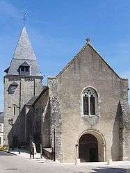
The church in Limeray | ||
| ||
 Limeray | ||
|
Location within Centre-Val de Loire region  Limeray | ||
| Coordinates: 47°27′37″N 1°02′33″E / 47.4603°N 1.0425°ECoordinates: 47°27′37″N 1°02′33″E / 47.4603°N 1.0425°E | ||
| Country | France | |
| Region | Centre-Val de Loire | |
| Department | Indre-et-Loire | |
| Arrondissement | Tours | |
| Canton | Amboise | |
| Government | ||
| • Mayor (2008–2014) | Jean-Jacques Breussin | |
| Area1 | 14.39 km2 (5.56 sq mi) | |
| Population (2009)2 | 1,143 | |
| • Density | 79/km2 (210/sq mi) | |
| Time zone | CET (UTC+1) | |
| • Summer (DST) | CEST (UTC+2) | |
| INSEE/Postal code | 37131 / 37530 | |
| Elevation | 52–116 m (171–381 ft) | |
|
1 French Land Register data, which excludes lakes, ponds, glaciers > 1 km² (0.386 sq mi or 247 acres) and river estuaries. 2 Population without double counting: residents of multiple communes (e.g., students and military personnel) only counted once. | ||
.svg.png)
Limeray is a commune in the Indre-et-Loire department in central France.
Population
| Historical population | ||
|---|---|---|
| Year | Pop. | ±% |
| 1793 | 1,062 | — |
| 1800 | 1,115 | +5.0% |
| 1806 | 1,118 | +0.3% |
| 1821 | 1,180 | +5.5% |
| 1831 | 1,129 | −4.3% |
| 1836 | 1,157 | +2.5% |
| 1841 | 1,107 | −4.3% |
| 1846 | 1,107 | +0.0% |
| 1851 | 1,161 | +4.9% |
| 1856 | 1,161 | +0.0% |
| 1861 | 1,177 | +1.4% |
| 1866 | 1,163 | −1.2% |
| 1872 | 1,063 | −8.6% |
| 1876 | 1,089 | +2.4% |
| 1881 | 1,061 | −2.6% |
| 1886 | 1,036 | −2.4% |
| 1891 | 1,010 | −2.5% |
| 1896 | 1,019 | +0.9% |
| 1901 | 961 | −5.7% |
| 1906 | 974 | +1.4% |
| 1911 | 950 | −2.5% |
| 1921 | 935 | −1.6% |
| 1926 | 867 | −7.3% |
| 1931 | 843 | −2.8% |
| 1936 | 765 | −9.3% |
| 1946 | 852 | +11.4% |
| 1954 | 841 | −1.3% |
| 1962 | 855 | +1.7% |
| 1968 | 896 | +4.8% |
| 1975 | 886 | −1.1% |
| 1982 | 910 | +2.7% |
| 1990 | 972 | +6.8% |
| 1999 | 945 | −2.8% |
| 2006 | 1,055 | +11.6% |
| 2009 | 1,143 | +8.3% |
See also
References
| Wikimedia Commons has media related to Limeray. |
This article is issued from Wikipedia - version of the 2/18/2015. The text is available under the Creative Commons Attribution/Share Alike but additional terms may apply for the media files.