Faye-la-Vineuse
| Faye-la-Vineuse | |
|---|---|
|
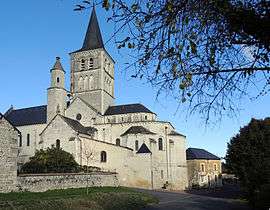
The collegiate church of Saint-Georges, in Faye-la-Vineuse | |
 Faye-la-Vineuse | |
|
Location within Centre-Val de Loire region  Faye-la-Vineuse | |
| Coordinates: 46°57′28″N 0°20′28″E / 46.9578°N 0.3411°ECoordinates: 46°57′28″N 0°20′28″E / 46.9578°N 0.3411°E | |
| Country | France |
| Region | Centre-Val de Loire |
| Department | Indre-et-Loire |
| Arrondissement | Chinon |
| Canton | Richelieu |
| Government | |
| • Mayor (2008–2014) | Jean-Luc Auvray |
| Area1 | 17.55 km2 (6.78 sq mi) |
| Population (2009)2 | 304 |
| • Density | 17/km2 (45/sq mi) |
| Time zone | CET (UTC+1) |
| • Summer (DST) | CEST (UTC+2) |
| INSEE/Postal code | 37105 / 37120 |
| Elevation | 62–131 m (203–430 ft) |
|
1 French Land Register data, which excludes lakes, ponds, glaciers > 1 km² (0.386 sq mi or 247 acres) and river estuaries. 2 Population without double counting: residents of multiple communes (e.g., students and military personnel) only counted once. | |
Faye-la-Vineuse is a commune in the Indre-et-Loire department in central France.
Population
| Historical population | ||
|---|---|---|
| Year | Pop. | ±% |
| 1793 | 387 | — |
| 1800 | 732 | +89.1% |
| 1806 | 660 | −9.8% |
| 1821 | 697 | +5.6% |
| 1831 | 687 | −1.4% |
| 1836 | 722 | +5.1% |
| 1841 | 725 | +0.4% |
| 1846 | 756 | +4.3% |
| 1851 | 808 | +6.9% |
| 1856 | 798 | −1.2% |
| 1861 | 805 | +0.9% |
| 1866 | 741 | −8.0% |
| 1872 | 721 | −2.7% |
| 1876 | 719 | −0.3% |
| 1881 | 678 | −5.7% |
| 1886 | 677 | −0.1% |
| 1891 | 604 | −10.8% |
| 1896 | 625 | +3.5% |
| 1901 | 624 | −0.2% |
| 1906 | 634 | +1.6% |
| 1911 | 598 | −5.7% |
| 1921 | 510 | −14.7% |
| 1926 | 512 | +0.4% |
| 1931 | 533 | +4.1% |
| 1936 | 526 | −1.3% |
| 1946 | 514 | −2.3% |
| 1954 | 522 | +1.6% |
| 1962 | 583 | +11.7% |
| 1968 | 597 | +2.4% |
| 1975 | 490 | −17.9% |
| 1982 | 409 | −16.5% |
| 1990 | 343 | −16.1% |
| 1999 | 285 | −16.9% |
| 2006 | 313 | +9.8% |
| 2009 | 304 | −2.9% |
See also
References
| Wikimedia Commons has media related to Faye-la-Vineuse. |
This article is issued from Wikipedia - version of the 2/18/2015. The text is available under the Creative Commons Attribution/Share Alike but additional terms may apply for the media files.