Marcilly-sur-Maulne
| Marcilly-sur-Maulne | ||
|---|---|---|
|
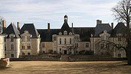
Chateau | ||
| ||
 Marcilly-sur-Maulne | ||
|
Location within Centre-Val de Loire region  Marcilly-sur-Maulne | ||
| Coordinates: 47°33′05″N 0°14′32″E / 47.5514°N 0.2422°ECoordinates: 47°33′05″N 0°14′32″E / 47.5514°N 0.2422°E | ||
| Country | France | |
| Region | Centre-Val de Loire | |
| Department | Indre-et-Loire | |
| Arrondissement | Tours | |
| Canton | Château-la-Vallière | |
| Government | ||
| • Mayor (2008–2014) | Dominique Guinoiseau | |
| Area1 | 14.6 km2 (5.6 sq mi) | |
| Population (2009)2 | 226 | |
| • Density | 15/km2 (40/sq mi) | |
| Time zone | CET (UTC+1) | |
| • Summer (DST) | CEST (UTC+2) | |
| INSEE/Postal code | 37146 / 37330 | |
| Elevation | 47–121 m (154–397 ft) | |
|
1 French Land Register data, which excludes lakes, ponds, glaciers > 1 km² (0.386 sq mi or 247 acres) and river estuaries. 2 Population without double counting: residents of multiple communes (e.g., students and military personnel) only counted once. | ||
.svg.png)
Marcilly-sur-Maulne is a commune in the Indre-et-Loire department in central France.
Population
| Historical population | ||
|---|---|---|
| Year | Pop. | ±% |
| 1793 | 580 | — |
| 1800 | 337 | −41.9% |
| 1806 | 552 | +63.8% |
| 1821 | 550 | −0.4% |
| 1831 | 716 | +30.2% |
| 1836 | 669 | −6.6% |
| 1841 | 704 | +5.2% |
| 1846 | 653 | −7.2% |
| 1851 | 664 | +1.7% |
| 1856 | 585 | −11.9% |
| 1861 | 570 | −2.6% |
| 1866 | 593 | +4.0% |
| 1872 | 569 | −4.0% |
| 1876 | 573 | +0.7% |
| 1881 | 543 | −5.2% |
| 1886 | 593 | +9.2% |
| 1891 | 602 | +1.5% |
| 1896 | 582 | −3.3% |
| 1901 | 572 | −1.7% |
| 1906 | 589 | +3.0% |
| 1911 | 542 | −8.0% |
| 1921 | 461 | −14.9% |
| 1926 | 497 | +7.8% |
| 1931 | 462 | −7.0% |
| 1936 | 471 | +1.9% |
| 1946 | 478 | +1.5% |
| 1954 | 427 | −10.7% |
| 1962 | 397 | −7.0% |
| 1968 | 315 | −20.7% |
| 1975 | 275 | −12.7% |
| 1982 | 245 | −10.9% |
| 1990 | 241 | −1.6% |
| 1999 | 237 | −1.7% |
| 2006 | 257 | +8.4% |
| 2009 | 226 | −12.1% |
See also
References
| Wikimedia Commons has media related to Marcilly-sur-Maulne. |
This article is issued from Wikipedia - version of the 2/18/2015. The text is available under the Creative Commons Attribution/Share Alike but additional terms may apply for the media files.