Trail Ridge Road
| |
|---|---|
| Trail Ridge Road | |
|
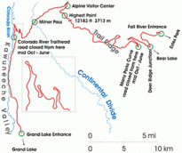
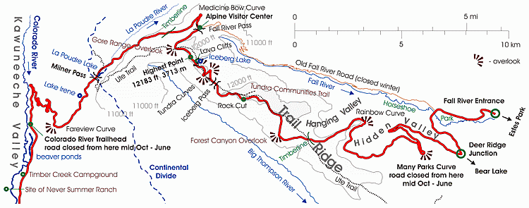
Schematic map of the Trail Ridge Road | |
| Route information | |
| Maintained by NPS | |
| Length: | 48 mi (77 km) |
| Existed: | 1932 – present |
| Tourist routes: |
|
| Major junctions | |
| West end: | Grand Lake |
| East end: | Estes Park |
| Location | |
| Counties: | Grand County, Larimer County |
| Highway system | |
|
Colorado State Highways
| |
|
Trail Ridge Road | |
| NRHP Reference # | 84000242[1] |
| Added to NRHP | November 14, 1984 |

| Wikimedia Commons has media related to Trail Ridge Road. |
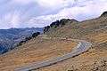
Trail Ridge Road is the name for a stretch of U.S. Highway 34 that traverses Rocky Mountain National Park from Estes Park, Colorado in the east to Grand Lake, Colorado in the west. The road is also known as Trail Ridge Road/Beaver Meadow National Scenic Byway,
Trail Ridge Road is closed during the winter, and often remains closed until late spring or early summer depending on the snowpack. It requires access to Rocky Mountain National Park even for local residents.
Route description

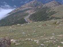
| This image is of generally poor quality. Please upload a better quality version if available, or try to avoid its use. This image is considered to be of low quality because blurry and low resolution |
From Kawuneeche Visitor Center at the park's Grand Lake Entrance, Trail Ridge Road follows the North Fork of the Colorado River north through the Kawuneeche Valley. There are several trailheads along this section of the road, notably the Colorado River Trailhead, which is the western terminus of the road segment closed during the winter.
The road crosses the Continental Divide at Milner Pass (elev. 10,758 ft or 3,279 m) and reaches a maximum elevation of 12,183 ft (3,713 m), near Fall River Pass (elev. 11,796 ft or 3,595 m). Near the highest point on the road is another pass, Iceberg Pass (elev. 11,827 ft or 3,605 m).
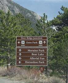
According to construction contracts and park maintenance files the east end of the road is located at the Fall River Entrance, however some guides state that earlier - at Deer Ridge Junction.[3]
Trail Ridge is a high flat spur range extending east from the main range of the Rockies between Fall River in the North and the Big Thompson River in the South. The road follows Trail Ridge from the Fall River Pass near Alpine Visitor Center to the Deer Ridge Junction.[3]

History
Fall River Road was the first road into the park's high country. It opened in 1921 and quickly proved inadequate for motor travel as a single-track road with steep grades (up to 16%), tight curves and a short annual season due to snowpack.[4] Construction began in 1929 and was complete to Fall River Pass by July 1932, with a maximum grade of 7%. The road was complete through the Kawuneeche Valley to Grand Lake in 1938.[5] The route followed what was known to local Arapaho Indians as the Dog Trail. Internal opposition to the construction of a road through the park's alpine tundra was overruled by National Park Service director Horace Albright, who wished to encourage park visitation. The road was designed to intrude as little as possible into the landscape, in accordance with Park Service design principles.[6]
Hidden Valley (or Ski Estes Park) was a local ski area attraction from 1955 - 1991, off of Trail Ridge Road, now in defunct status.[7]
Before the road was constructed
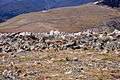
Trail Ridge had been used by Native Americans to cross the mountains between their home lands in the west and hunting areas on the east side. Arapahoe Indians called the trail located on the ridge as "taienbaa" ("Where the Children Walked") because it was so steep that children could not be carried, but had to walk. The Ute tribe crossing the mountains at Forest Canyon Pass marked their route with stone cairns. The present park Ute Trail follows partially that ancient route.[3]
On the west side, about 1880, a wagon road was constructed along the Kawuneeche Valley from the town of Grand Lake to the mining camps of Lulu City and Gaskil. The camps were abandoned after a few years when short-lived mining boom ended and later the road was used only occasionally by hunters and tourists.[3]
Gallery


See also
References
- ↑ National Park Service (2010-07-09). "National Register Information System". National Register of Historic Places. National Park Service. Retrieved September 29, 2013.
- ↑ "Forest Health". National Park Service. Retrieved 12 Jan 2013.
Road crews use tall and narrow trees as snow poles to mark road edges affected by deep snow. These snow poles help facilitate plowing operations throughout the year, especially when opening Trail Ridge Road.
- 1 2 3 4 Quin, Richard (August 1993). Trail Ridge Road, Rocky Mountain National Park, HAER No. CO-31 (PDF). Historic American Engineering Record. Washington D.C.: National Park Service, U.S. Department of the Interior. Retrieved 2013-07-29.
- ↑ "Scenic Drives". Rocky Mountain National Park. National Park Service. Retrieved 2007-08-23.
- ↑ "History of Trail Ridge Road". Rocky Mountain National Park. National Park Service. Retrieved 29 August 2011.
- ↑ Noel, Thomas J. (1997). Buildings of Colorado. Oxford University Press. p. 457. ISBN 0-19-515247-6.
- ↑ Colorado Ski History: Hidden Valley (Ski Estes Park)
External links
- Rocky Mountain National Park Official Site
- Trail Ridge Road/Beaver Meadow Road Overview on the National Scenic Byways website
- Trail Ridge Road on the Colorado Scenic Byways website
- Trail Ridge Tour in Google Earth - a camera flying around Trail Ridge (KML file)
| Topics | |
|---|---|
| Lists by states |
|
| Lists by insular areas | |
| Lists by associated states | |
| Other areas | |
| |
