East Longs Peak Trail – Longs Peak Trail – Keyhole Route – Shelf Trail
|
East Longs Peak Trail--Longs Peak Trail--Keyhole Route--Shelf Trail | |
|
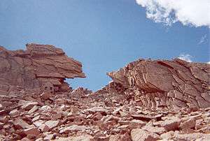
Along the Keyhole Route | |
  | |
| Location | Rocky Mountain National Park, Colorado, USA |
|---|---|
| Nearest city | Allenspark, Colorado |
| Built | 1925 |
| Architect | National Park Service |
| MPS | Rocky Mountain National Park MPS |
| NRHP Reference # | 07000740 |
| Added to NRHP | July 10, 2007[1] |
The East Longs Peak Trail, Longs Peak Trail and Keyhole Route-Shelf Trail in Rocky Mountain National Park are listed on the National Register of Historic Places for their significance in the early recreational development of the park. The East Longs Peak Trail was laid out in 1878 by Reverend Elkanah Lamb, long before the designation of the region as parkland. It was extended in 1910 by Enos Mills. The trail leads from the Tahosa Valley, running counterclockwise around Longs Peak and reaching the summit at 14,259 feet.[2]
See also
National Register of Historic Places listings in Larimer County, Colorado
References
- ↑ National Park Service (2008-04-15). "National Register Information System". National Register of Historic Places. National Park Service.
- ↑ "East Long Peak Trail". List of Classified Structures. National Park Service. 2009-01-10.
Coordinates: 40°16′20″N 105°36′02″W / 40.27222°N 105.60056°W
| Topics | |
|---|---|
| Lists by states |
|
| Lists by insular areas | |
| Lists by associated states | |
| Other areas | |
| |
This article is issued from Wikipedia - version of the 11/17/2016. The text is available under the Creative Commons Attribution/Share Alike but additional terms may apply for the media files.