Jackson County, Colorado
| Jackson County, Colorado | |
|---|---|
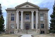 Jackson County courthouse in Walden Colorado | |
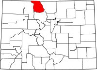 Location in the U.S. state of Colorado | |
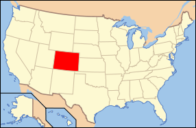 Colorado's location in the U.S. | |
| Founded | May 5, 1909 |
| Named for | Andrew Jackson |
| Seat | Walden |
| Largest town | Walden |
| Area | |
| • Total | 1,621 sq mi (4,198 km2) |
| • Land | 1,614 sq mi (4,180 km2) |
| • Water | 7.2 sq mi (19 km2), 0.4% |
| Population (est.) | |
| • (2015) | 1,356 |
| • Density | 1/sq mi (0/km²) |
| Congressional district | 3rd |
| Time zone | Mountain: UTC-7/-6 |
Jackson County is a county in the state of Colorado. As of the 2010 census, the population was 1,394, and it was the fourth least-densely populated in the state.[1] The county seat and only incorporated municipality in the county is Walden.[2]
History
Most of Jackson County is a high relatively broad intermontane basin known as North Park, which covers 1,613 square miles (4,180 km2). This basin opens north into Wyoming and is rimmed on the west by the Park Range, on the south by the Rabbit Ears Range and the Never Summer Mountains, and on the east by the Medicine Bow Mountains. Elevations range from 7,800 to 12,953 feet (3,948 m) above sea level and is home to the head waters of the North Platte River. The term park is derived from parc, the French word for game preserve. At one time North Park was filled with herds of deer, antelope and buffalo. There were so many buffalo in the area the Ute Tribe gave North Park the name "Bull Pen." Now deer, elk, and cattle vie for the same area.
In November 1861, Colorado set up 17 counties for the state, including Larimer County. This was where Jackson County would be carved out of in 1909. Before then, both Grand and Larimer Counties claimed the North Park area. In the beginning, no one paid much attention to North Park because it was hunting grounds of the Ute and Arapaho Indians. They fiercely defended these lands and the white settlers were often afraid to venture in. When valuable minerals were discovered in North Park, Grand County claimed it as part of their county because they wanted the revenue it would provide. The residents didn't care much because the county seat for Grand County was closer than the one in Larimer County, and all official business needed to be done at the county seat. But Larimer also claimed this county and it was contested all the way to the Colorado Supreme Court. In 1886 the court decided in favor of Larimer. This did not make the North Park residents very happy and they pushed for their own county until Jackson was formed.
Geography
According to the U.S. Census Bureau, the county has a total area of 1,621 square miles (4,200 km2), of which 1,614 square miles (4,180 km2) is land and 7.2 square miles (19 km2) (0.9%) is water.[3]
Jackson County contains the 71,000-acre (290 km2) Colorado State Forest.
Adjacent counties
- Albany County, Wyoming - northeast
- Larimer County - east
- Grand County - southeast
- Routt County - west
- Carbon County, Wyoming - northwest
Demographics
| Historical population | |||
|---|---|---|---|
| Census | Pop. | %± | |
| 1910 | 1,013 | — | |
| 1920 | 1,340 | 32.3% | |
| 1930 | 1,386 | 3.4% | |
| 1940 | 1,798 | 29.7% | |
| 1950 | 1,976 | 9.9% | |
| 1960 | 1,758 | −11.0% | |
| 1970 | 1,811 | 3.0% | |
| 1980 | 1,863 | 2.9% | |
| 1990 | 1,605 | −13.8% | |
| 2000 | 1,577 | −1.7% | |
| 2010 | 1,394 | −11.6% | |
| Est. 2015 | 1,356 | [4] | −2.7% |
| U.S. Decennial Census[5] 1790-1960[6] 1900-1990[7] 1990-2000[8] 2010-2015[1] | |||
As of the census of 2000, there were 1,577 people, 661 households, and 442 families residing in the county. The population density was 1 people per square mile (0.25/km²). There were 1,145 housing units at an average density of 1 per square mile (0/km²). The racial makeup of the county was 96.20% White, 0.25% Black or African American, 0.76% Native American, 0.06% Asian, 1.46% from other races, and 1.27% from two or more races. 6.53% of the population were Hispanic or Latino of any race.
There were 661 households out of which 29.20% had children under the age of 18 living with them, 54.90% were married couples living together, 7.90% had a female householder with no husband present, and 33.00% were non-families. 28.40% of all households were made up of individuals and 10.10% had someone living alone who was 65 years of age or older. The average household size was 2.37 and the average family size was 2.91.
In the county the population was spread out with 25.60% under the age of 18, 5.40% from 18 to 24, 26.90% from 25 to 44, 29.10% from 45 to 64, and 13.10% who were 65 years of age or older. The median age was 40 years. For every 100 females there were 101.40 males. For every 100 females age 18 and over, there were 107.80 males.
The median income for a household in the county was $31,821, and the median income for a family was $37,361. Males had a median income of $26,250 versus $18,417 for females. The per capita income for the county was $17,826. About 10.30% of families and 14.00% of the population were below the poverty line, including 22.50% of those under age 18 and 9.00% of those age 65 or over.
Recreation
State forest and park
National wildlife refuge
National forest and wilderness
National trail
Bicycle routes
Scenic byway
- Cache La Poudre-North Park Scenic and Historic Byway
Communities
Town
Unincorporated communities
Former Towns
- Brownlee
- Hebron
- Old Homestead
- Owl
- Pearl
- Spicer
- Teller City
- Zirkel
See also
- Outline of Colorado
- Index of Colorado-related articles
- North County, Jefferson Territory
- National Register of Historic Places listings in Jackson County, Colorado
References
- 1 2 "State & County QuickFacts". United States Census Bureau. Retrieved June 8, 2014.
- ↑ "Find a County". National Association of Counties. Archived from the original on May 31, 2011. Retrieved 2011-06-07.
- ↑ "US Gazetteer files: 2010, 2000, and 1990". United States Census Bureau. 2011-02-12. Retrieved 2011-04-23.
- ↑ "County Totals Dataset: Population, Population Change and Estimated Components of Population Change: April 1, 2010 to July 1, 2015". Retrieved July 2, 2016.
- ↑ "U.S. Decennial Census". United States Census Bureau. Archived from the original on May 11, 2015. Retrieved June 8, 2014.
- ↑ "Historical Census Browser". University of Virginia Library. Retrieved June 8, 2014.
- ↑ "Population of Counties by Decennial Census: 1900 to 1990". United States Census Bureau. Retrieved June 8, 2014.
- ↑ "Census 2000 PHC-T-4. Ranking Tables for Counties: 1990 and 2000" (PDF). United States Census Bureau. Retrieved June 8, 2014.
External links
- Jackson County Government Website
- Colorado County Evolution by Don Stanwyck
- Colorado Historical Society
 |
Carbon County, Wyoming | Albany County, Wyoming | | |
| Routt County | |
Larimer County | ||
| ||||
| | ||||
| Grand County |
Municipalities and communities of Jackson County, Colorado, United States | ||
|---|---|---|
| Town | | |
| Unincorporated communities | ||

Coordinates: 40°40′N 106°20′W / 40.66°N 106.34°W