Sayala (India)
| Sayala सायला Sayla | |
|---|---|
| village | |
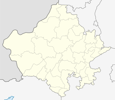 Sayala  Sayala Location in Jalore, Rajasthan, India | |
| Coordinates: 25°19′59″N 72°22′01″E / 25.333°N 72.367°ECoordinates: 25°19′59″N 72°22′01″E / 25.333°N 72.367°E | |
| Country |
|
| State | Rajasthan |
| District | Jalor |
| Government | |
| • Body | Gram Panchayat |
| Elevation | 117 m (384 ft) |
| Population (2011) | |
| • Total | 28,000 |
| Languages | |
| • Official | Hindi |
| Time zone | IST (UTC+5:30) |
| PIN | 343022 |
| Telephone code | 02977 |
| Vehicle registration | RJ-16 |
| Sex ratio | 934 ♂/♀ |
Sayala is a Village in the Jalore district of Rajasthan state of North western India. It is the headquarters of Sayala Tehsil. Sayla also have SDM ( Sub District Magistrate ) Headquarter. It is connected with SH-16 Chetak Road/ Border Road Organisation. Its border touches the Barmer District. The legislative of Sayla is Jalore.
Demographics
As of 2001 India census,[1] Sayala had a population of 137804. Males constitute 6,657 of the population and females 6,216.
Schools in Sayla
| S.No. | Name of School | Level | Contact Number |
|---|---|---|---|
| 01 | Govt. High School | Senior Secondary | Not Available |
| 02 | Govt. Girls High School | Senior Secondary | Not Available |
References
- ↑ "Census of India 2001: Data from the 2001 Census, including cities, villages and towns (Provisional)". Census Commission of India. Archived from the original on 2004-06-16. Retrieved 2008-11-01.
| Outline |  | ||||||||||||||||||||||||||
|---|---|---|---|---|---|---|---|---|---|---|---|---|---|---|---|---|---|---|---|---|---|---|---|---|---|---|---|
| Governance | |||||||||||||||||||||||||||
| Divisions and Districts |
| ||||||||||||||||||||||||||
| Major cities | |||||||||||||||||||||||||||
| Related templates |
| ||||||||||||||||||||||||||
This article is issued from Wikipedia - version of the 10/5/2016. The text is available under the Creative Commons Attribution/Share Alike but additional terms may apply for the media files.