Chittorgarh district
Chittorgarh District is a district of Rajasthan state in western India. The historic city of Chittorgarh is the administrative headquarters of the district.
The district has an area of 10,856 km², and a population of 1,802,656 (2001 census). The district is disjunct, divided into a larger western portion and a smaller eastern portion by Neemuch District of Madhya Pradesh. The western portion is bounded by Neemuch, Mandsaur, and Ratlam districts of Madhya Pradesh to the east, and the Rajasthan district of Pratapgarh to the south, Udaipur and Rajsamand to the east, and Bhilwara to the north. The eastern portion is bounded by Bhilwara, Bundi, and Kota districts of Rajasthan to the north and Neemuch District of Madhya Pradesh to the south and west. It is divided into 10 tehsils which are: Chittorgarh, Rashmi, Gangrar, Begun, Kapasan, Rawatbhata, Dungla, bhadesar, Bari Sadri and Nimbahera.
Economy
In 2006 the Ministry of Panchayati Raj named Chittorgarh one of the country's 250 most backward districts (out of a total of 640).[1] It is one of the twelve districts in Rajasthan currently receiving funds from the Backward Regions Grant Fund Programme (BRGF).[1]
Demographics
According to the 2011 census Chittorgarh district has a population of 1,544,392,[2] roughly equal to the nation of Gabon[3] or the US state of Hawaii.[4] This gives it a ranking of 323rd in India (out of a total of 640).[2] The district has a population density of 193 inhabitants per square kilometre (500/sq mi) .[2] Its population growth rate over the decade 2001-2011 was 16.09%.[2] Chittaurgarh has a sex ratio of 970 females for every 1000 males,[2] and a literacy rate of 62.51%.[2]
Places of Interest

Chittorgarh Fort
The Chittorgarh Fort seated on a 180-metre hill, covers an expanse of 700 acres (2.8 km2). It was constructed by the Mauryans in the 7th century AD. There is also a belief that it was constructed by Bhima of the Pancha Pandavas. This fort was the citadel of many great Indian warriors such as Gora, Badal,Rana Kumbha, Maharana Pratap, Jaimal, Patta, etc.
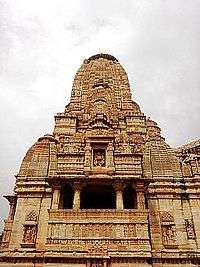
Kalika Mata Temple
Kalika Mata Temple was originally built in the 8th century for Sun God and was later converted to a temple for mother Goddess, Kali in the 14th century.During the festival days of Navaratri, fairs are organised and pilgrims from different places come here to pay obeisance at the temple.
Vijay Stambh
Vijay Stambha, is a huge nine storey tower which was built by Maharana Kumbha to commemorate his victory over the rulers of Malwa and Gujarat in 1440. The tower is 122 ft (37 m) high and stands on a 10 ft (3.0 m) high base. There are sculptures and carvings on the exterior walls of the tower. The tower is visible from any section of the town below. And for reaching tower top one have to climb 157 steps, one can take great view of the surroundings. The inside walls of the tower are carved with images of Gods, weapons, etc.
Kirti Stambh


Kirti Stambh (Tower of Fame) is a 22-metre-high (72 ft) tower built in 12th-century.Kirti Stambh is built inside Chittorgarh fort. It is dedicated to Rishabha, the first Tirthankara of Jainism. It was built by a merchant and is decorated with figures form the Jain pantheon.It is a seven storied pillar which was built by Biherwal Mahajan Sanaya of Digambar Jain sect during 12th century AD. On its four corners are engraved idols of Shri Adinathji in Digambar style which each are five feet (about 1.5meters) high and elsewhere are engraved several small idols consecrated to Jain lineage of deities.
Rana Kumbha's Palace
Rana Kumbha's Palace is near the Vijay Stambh. This is the birthplace of Maharana Udai Singh, the founder of Udaipur. His life was saved by the heroic act of the maid Panna Dhay, who replaced her son in place of the prince, with the result that her son was killed by Banbir. She carried the prince away to safety in a fruit basket. Rani Meera Bai also lived in this palace. This is the place where Rani Padmini committed jauhar with the other ladies in one of the underground cellars.
Rani Padmini's Palace

Rani Padmini's Palace is from which Alauddin Khilji (one of the rulers of Khilji dynasty during the sultanate rule over India) was allowed to watch a reflection of the Rani by replacing the mirror at such an angle that even if he turned back he could not see the room. Khilji had been warned by the Rani's husband Rawal Ratan Singh that if he turned back they would cut his neck.
See Also
References
- 1 2 Ministry of Panchayati Raj (September 8, 2009). "A Note on the Backward Regions Grant Fund Programme" (PDF). National Institute of Rural Development. Archived from the original (PDF) on April 5, 2012. Retrieved September 27, 2011.
- 1 2 3 4 5 6 "District Census 2011". Census2011.co.in. 2011. Retrieved 2011-09-30.
- ↑ US Directorate of Intelligence. "Country Comparison:Population". Retrieved 2011-10-01.
Gabon 1,576,665
- ↑ "2010 Resident Population Data". U. S. Census Bureau. Archived from the original on 2013-10-19. Retrieved 2011-09-30.
Hawaii 1,360,301
External links
 |
Rajsamand district | Bhilwara district | | |
| |
||||
| ||||
| | ||||
| Udaipur district | Pratapgarh district | Neemuch district, Rajasthan |
| |
Bhilwara district | Bundi district | | |
| |
Kota district | |||
| ||||
| | ||||
| Neemuch district, Rajasthan | Mandsaur district, Rajasthan |
| Outline | 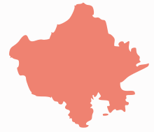 | ||||||||||||||||||||||||||
|---|---|---|---|---|---|---|---|---|---|---|---|---|---|---|---|---|---|---|---|---|---|---|---|---|---|---|---|
| Governance | |||||||||||||||||||||||||||
| Divisions and Districts |
| ||||||||||||||||||||||||||
| Major cities | |||||||||||||||||||||||||||
| Related templates |
| ||||||||||||||||||||||||||
Coordinates: 24°52′48″N 74°37′12″E / 24.88000°N 74.62000°E