Sarigan
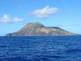 Sarigan from the east | |
 | |
| Geography | |
|---|---|
| Location | Pacific Ocean |
| Coordinates | 16°42′N 145°47′E / 16.700°N 145.783°E |
| Archipelago | Northern Mariana Islands |
| Area | 4.5 km2 (1.7 sq mi) |
| Length | 2.7 km (1.68 mi) |
| Width | 2.5 km (1.55 mi) |
| Highest elevation | 538 m (1,765 ft) |
| Administration | |
|
United States | |
| Commonwealth | Northern Mariana Islands |
| Demographics | |
| Population | - uninhabited - (2010) |
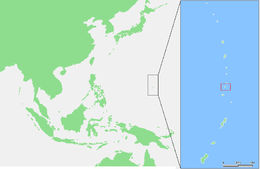
Sarigan is an uninhabited volcanic island in the Pacific Ocean. It is part of the Northern Mariana Islands, a U.S. territory. Sarigan is located 37 kilometers (20 nmi) northeast of Anatahan island, 67 km (36 nmi) south of Guguan and 150 km (81 nmi) north of Saipan, the largest island in the Northern Marianas.
Geography
Sarigan is roughly triangular in shape, with a length of 2.7 kilometers (1.7 mi) and a width of 2.5 km (1.6 mi) and an area of 4.5 km2 (1.7 sq mi).[1] The island is the summit of Holocene era stratovolcano which rises to an altitude of 538 m (1,765 ft) above sea level at its highest peak. The volcano is topped by a caldera, 750 meters in diameter, with an ash cone and two lava domes, which produced lava flows which reached the coast. No eruptions have been recorded in the historical period, although a swarm of volcano-tectonic earthquakes took place here in the summer of 2005.
Landing on Sarigan is difficult due to perpendicular cliffs surrounding the island. It has many ravines and valleys with dense tropical vegetation.
Approximately 12 km (6.5 nmi) south of Sarigan is the South Sarigan Seamount, a submarine volcano with several peaks, with a maximum height of approximately 184 meters below sea level. It briefly erupted in May 2010 producing a plume of water vapor approximately 12 kilometers high.
History
Sarigan was originally settled by the Chamorros.[2] The island was first charted by Europeans in late October 1543 by Spanish explorer Bernardo de la Torre on board of the carrack San Juan de Letrán when trying to return from Sarangani to New Spain.[3][4] In 1695, the natives were forcibly removed to Saipan, and three years later to Guam.
Following the sale of the Northern Marianas by Spain to the German Empire in 1899, Agrigan was administered as part of German New Guinea. The island was used as a penal colony from 1900-1906. The prisoners, who lived some with their families on Sarigan were mainly employed by the coconut plantations.[5] In 1909, the island was leased by the Pagan Society, a German-Japanese partnership, which continued to export copra. However, the Pagan Society fell into financial difficulties from 1912. The company also employed fowlers to hunt birds for feathers for export to Japan and Europe.[6]
During World War I, Sarigan came under the control of the Empire of Japan and was administered as the South Pacific Mandate. In the 1930s, between 10 and 20 families lived on the island.[7]
Following World War II, the island came under the control of the United States and after World War II, the residents were removed from the island. As of 1947, the island was administered as part of the Trust Territory of the Pacific Islands. Since 1978, the island has been part of the Northern Islands Municipality of the Commonwealth of the Northern Mariana Islands.
Today, the island is a nature preserve, and in the mid-1990s, a project was launched to rid Sarigan of its population of feral animals; today, only a few cats remain. Sarigan has been proposed as a site for relocation of endangered birds from Guam and Saipan.
On May 28, 2010 a submarine volcano 7 mi (11 km) to the south erupted a brief cloud of steam and ash that briefly rose to 49,000 ft (15,000 m) and left a trail of pumice debris on the surface of the water. Sarigan was declared off-limits by the government of the Northern Mariana Islands after the eruption.[8]
References
- Russell E. Brainard et al.: Coral reef ecosystem monitoring report of the Mariana Archipelago: 2003–2007. (=PIFSC Special Publication, SP-12-01) NOAA Fisheries, Pacific Islands Fisheries Science Center 2012 (Kapitel Alamagan (englisch, PDF, 12,2 MB)).
- Richard B. Moore, Frank A. Trusdell: Geologic map of Alamagan Volcano, northern Mariana Islands. United States Geological Survey 1993 (Download).
External links
| Wikimedia Commons has media related to Sarigan Island. |
- Google Maps: Sarigan (in German)
- "Sarigan". Global Volcanism Program. Smithsonian Institution.
- Pascal Horst Lehne and Christoph Gäbler: Über die Marianen. Lehne-Verlag, Wohldorf in Germany 1972. and Sarigan (in German)
Notes
- ↑ Brainard, Coral reef ecosystem monitoring report, S. 1
- ↑ Dirk HR Speenemann: Combining Curiosity with Political Skill: The Antiquarian Interests and Cultural Politics of Georg Fritz. In: Micronesian journal of the humanities and social sciences, 2006(5), S. 495–504, hier S. 498.
- ↑ Brand, Donald D. The Pacific Basin: A History of its Geographical Explorations New York: The American Geographical Society (New York, 1967) p.123.
- ↑ Welsch, Bernhard (2004). "Was Marcus Island Discovered by Bernardo de la Torre in 1543?". The Journal of Pacific History. 39 (1): 118. doi:10.1080/00223340410001684886.
- ↑ Gerd Hardach: König Kopra. Die Marianen unter deutscher Herrschaft 1899–1914. Steiner, Stuttgart 1990, ISBN 3515057625, S. 23f, 32, 46.
- ↑ Dirk HR Speenemann: Exploitation of bird plumages in the German Mariana Islands. In: Micronesica 1999(31) S. 309–318, hier S. 313.
- ↑ Brainard, Coral reef ecosystem monitoring report, S. 2.
- ↑ CNN News, 'Pacific submarine volcano issues 'big burp'", 31 May 2010 : accessed 31 May 2010
| Colonies |
| |||||||
|---|---|---|---|---|---|---|---|---|
| Concessions |
| |||||||
| Unrecognised |
| |||||||
Saipan (capital) | |
| Topics |
|
| Islands |
|
| Municipalities | |