Trust Territory of the Pacific Islands
| Trust Territory of the Pacific Islands | ||||||||||||||||
| United Nations Trust Territory | ||||||||||||||||
| ||||||||||||||||
| ||||||||||||||||
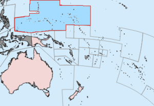 Location of the Trust Territory of the Pacific Islands in the Pacific. | ||||||||||||||||
| Capital | Saipan | |||||||||||||||
| Languages | English (official) Micronesian languages, Marshallese, Chamorro, Palauan | |||||||||||||||
| Government | Trust Territory | |||||||||||||||
| Chief of State | ||||||||||||||||
| • | 1947–1953 (first) | Harry S. Truman | ||||||||||||||
| • | 1993–1994 (last) | Bill Clintona | ||||||||||||||
| High Commissioner | ||||||||||||||||
| • | 1947–1948 (first) | Louis E. Denfeld | ||||||||||||||
| • | 1981–1987 (last) | Janet J. McCoyb | ||||||||||||||
| Historical era | Cold War | |||||||||||||||
| • | Trusteeship | July 18, 1947 | ||||||||||||||
| • | Termination of administration (Marshall Islands) | October 21, 1986 | ||||||||||||||
| • | Termination of administration (others) | November 3, 1986 | ||||||||||||||
| • | Free Association | October 1, 1994 | ||||||||||||||
| Area | ||||||||||||||||
| • | 1980 | 1,779 km² (687 sq mi) | ||||||||||||||
| Population | ||||||||||||||||
| • | 1980 est. | 132,929 | ||||||||||||||
| Density | 74.7 /km² (193.5 /sq mi) | |||||||||||||||
| Currency | United States dollar | |||||||||||||||
| ||||||||||||||||
| a. | Clinton was President when Palau's Compact of Free Association took effect. Ronald Reagan was President when the RMI, FSM, and CNMI's final status took effect. | |||||||||||||||
| b. | McCoy retired as High Commissioner in 1987. As Palau was still a part of the TTPI, it was administered by officials in the Office of Territorial and International Affairs until 1994. | |||||||||||||||


The Trust Territory of the Pacific Islands (TTPI) was a United Nations trust territory in Micronesia (western Pacific) administered by the United States from 1947 to 1986.
History

Spain initially claimed the islands that later comprised the territory of the Trust Territory of the Pacific Islands (TTPI).[1] Subsequently, Germany established competing claims over the islands.[1] The competing claims were eventually resolved in favor of Germany when Spain, following its loss of several possessions to the United States during the Spanish–American War, ceded its claims over the islands to Germany in 1899 pursuant to the German–Spanish Treaty (1899).[1] Germany, in turn, continued to retain possession until the islands were captured by Japan during World War I.[1] The League of Nations formally placed the islands in the former South Pacific Mandate, a mandate that authorized Japanese administration of the islands.[1] The islands then remained under Japanese control until captured by the United States in 1944 during World War II.[1]
The TTPI entered UN trusteeship pursuant to Security Council Resolution 21 on July 18, 1947 and was designated a "strategic area" in its 1947 trusteeship agreement. Article 83 of the UN Charter provided that, as such, its formal status as a UN trust territory could be terminated only by the Security Council, and not by the General Assembly as with other trust territories. The United States Navy controlled the TTPI from a headquarters in Guam until 1951, when the United States Department of the Interior took over control, administering the territory from a base in Saipan.[2]
The Territory contained 100,000 people scattered over a water area the size of continental United States. They represented a variety of cultures and spoke nine languages. The Ponapeans and Kusaieans, Marshallese and Palauans, Truckese, Yapese and Chamorros had little in common, except they were in the same general area of the Pacific Ocean.[3]
The large distances between people, lack of an economy, language and cultural barriers, all worked against the union. The six district centers became upscale slums, containing deteriorated Japanese-built roads, with electricity, modern music and distractions, alienated youth and bewildered elders. The remainder of the islands stayed as they were historically, not progressing, but not regressing.[3]
A Congress of Micronesia first levied an income tax in 1971. It affected mainly foreigners working at military bases in the region.[4]
On October 21, 1986, the U.S. ended its administration of the Marshall Islands District. The termination of U.S. administration of the Chuuk, Yap, Kosrae, Pohnpei, and the Mariana Islands districts of the TTPI soon followed on November 3, 1986. The Security Council formally ended the trusteeship for the Chuuk, Yap, Kosrae, Pohnpei, Mariana Islands, and Marshall Islands districts on December 22, 1990 pursuant to Security Council Resolution 683. On May 25, 1994, the Council ended the trusteeship for the Palau District pursuant to Security Council Resolution 956, after which the U.S. and Palau agreed to establish the latter's independence on October 1.
Geography
In 1969, the 100 occupied islands comprised 700 square miles (1,800 km2) over an area of 3,000,000 square miles (7,800,000 km2) of sea. The latter area was comparable in size to the continental United States.[5] The water area is about 2% of the Pacific Ocean.
Demographics
The population of the islands was 200,000 in the latter part of the 19th century. The population decreased to 100,000 by 1969 due to emigration, war, and disease. At that time, the population inhabited less than 100 out of 2,141 of the Marshall, Mariana, and Caroline Islands.[5]
Current status
The area is now divided into four jurisdictions:
Sovereign states in free association with the United States
The following sovereign states have become freely associated with the United States under the Compact of Free Association (COFA).
-
 Republic of the Marshall Islands - Established 1979, COFA effective October 21, 1986
 -
 Federated States of Micronesia - Established 1979, COFA effective November 3, 1986
 -
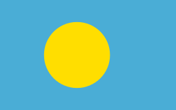 Republic of Palau - Established 1981, COFA effect October 1, 1994
Commonwealth in political union with the United States
-
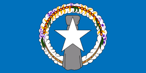 Commonwealth of the Northern Mariana Islands - New constitution partially effective January 1, 1978, and fully effective November 4, 1986.[6]
See also
- High Commissioner of the Trust Territory of the Pacific Islands
-
 Micronesia portal
References
- 1 2 3 4 5 6 Encyclopædia Britannica: Trust Territory of the Pacific Islands
- ↑ "Trust Territory of the Pacific Archives Photos – University of Hawaii". University of Hawaii at Manoa Hamilton Library.
- 1 2 Kluge, P. F. (December 1971). "Micronesia: America's Troubled Island Ward". Readers Digest from the Beacon Magazine of Hawaii. Pleasantville, NY. p. 161.
- ↑ Glenn B. Martineau (September 1976). "Micronesia's Simplified Income Tax System". American Bar Association Journal. p. 1176–1178.
- 1 2 "Remembering an adopted cousin". Time. New York City. May 23, 1969. p. 28.
- ↑ "Northern Mariana Islands". CIA World Factbook. Central Intelligence Agency. March 27, 2014. Retrieved April 5, 2014.
External links
![]() Media related to Trust Territory of the Pacific Islands at Wikimedia Commons
Media related to Trust Territory of the Pacific Islands at Wikimedia Commons
- Photos from the records of the Trust Territory Government
- 1967 Trust Territory of the Pacific Islands Census Geography
- United States Code: CHAPTER 14 - TRUST TERRITORY OF THE PACIFIC ISLANDS
- PACIFIC ISLANDS REPORT, Pacific Islands Development Program/East-West Center
- Compact of Free Association between the United States and the Federated States of Micronesia As Amended (2003) (pdf, archiveed from the original on 2003-10-05)
Coordinates: 10°30′N 152°00′E / 10.500°N 152.000°E