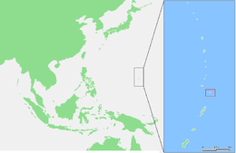
Farallon de Medinilla
 NOAA photo of Farallon de Medinilla | |
 | |
| Geography | |
|---|---|
| Location | Pacific Ocean |
| Coordinates | 16°1′2″N 146°3′31″E / 16.01722°N 146.05861°E |
| Archipelago | Northern Mariana Islands |
| Area | 0.845 km2 (0.326 sq mi) |
| Length | 2.8 km (1.74 mi) |
| Width | 0.5 km (0.31 mi) |
| Highest elevation | 81 m (266 ft) |
| Administration | |
|
United States | |
| Commonwealth | Northern Mariana Islands |
| Demographics | |
| Population | - uninhabited - (2010) |

Farallon de Medinilla is an uninhabited small island in the Northern Mariana Islands in the Pacific Ocean. It is located 45 nautical miles (83 km) north of Saipan, and is the smallest island in the archipelago (not counting the Zealandia Bank). Politically, it is part of the Northern Islands Municipality.
Geography
Farallon de Medinilla is roughly wedge-shaped, with a length of 2.8 kilometers (1.7 mi) and a width of 150 meters (490 ft) to the south, expanding to 530 m (1,740 ft) in the north, for an area of 0.845 km2 (0.326 sq mi). At its narrowest location, the island is only 20 m (66 ft) wide. The highest elevation on the island is 81 m (266 ft).
The shores are rimmed with cliffs containing caves and its tableland has some brush and savanna grass.[1][2][3]
Satellite imagery (e.g., Google Earth) of the island shows three X-shaped figures and one Y-shaped figure in its northern half, built out of metal shipping containers. These arrangements of shipping containers were left by the U.S. Navy for bomb targeting practice.[4]
History
Farallon de Medinilla was first charted by Europeans in late October 1543 by Spanish explorer Bernardo de la Torre on board of the carrack San Juan de Letrán when trying to return from Sarangani to New Spain.[5][6] Uninhabited at the time, later archaeological investigations have found blackened caves and pottery fragments indicating prior habitation by the Chamorros. The island was visited by Louis de Freycinet in 1819; it was named for Don Jose de Medinilla y Pifieda, the (Spanish) Governor of the Marianas from 1812-1822.[7]
Following the sale of the Northern Marianas by Spain to the German Empire in 1899, Farallon de Medinilla was administered as part of German New Guinea, During World War I, Anatahan came under the control of the Empire of Japan and was administered as part of the South Pacific Mandate. Following World War II, the island came under the control of the United States and was administered as part of the Trust Territory of the Pacific Islands. Since 1978, the island has been part of the Northern Islands Municipality of the Commonwealth of the Northern Mariana Islands.
For years, the U.S.Navy has used Farallon de Medinilla for military and bombing exercises. In a 2002 lawsuit, the Center for Biological Diversity charged the Navy with the destruction of wildlife habitat on the island. A subsequent court ruling ordered the U.S. Defense Department to cease bombing exercises on Farallon de Medinilla until they came in compliance with the Migratory Bird Treaty Act.[8]
References
- Russell E. Brainard et al.: Coral reef ecosystem monitoring report of the Mariana Archipelago: 2003–2007. (=PIFSC Special Publication, SP-12-01) NOAA Fisheries, Pacific Islands Fisheries Science Center 2012
| Wikimedia Commons has media related to Farallon de Medinilla. |
Notes
- ↑ http://web.archive.org/web/20101223015139/http://www.oceandots.com/pacific/mariana/medinilla.php
- ↑ Farallon de Medinilla: Blocks 1061 and 1992, Block Group 1, Census Tract 9501, Northern Islands Municipality, United States Census Bureau
- ↑ Pascal Horst Lehne and Christoph Gäbler: Über die Marianen. Lehne-Verlag, Wohldorf in Germany 1972.
- ↑ "Carrier Air Wing FIVE".
- ↑ Brand, Donald D. The Pacific Basin: A History of its Geographical Explorations New York: The American Geographical Society (New York, 1967) p.123.
- ↑ Welsch, Bernhard (2004). "Was Marcus Island Discovered by Bernardo de la Torre in 1543?". The Journal of Pacific History. 39 (1): 118. doi:10.1080/00223340410001684886.
- ↑ http://gaebler.info/sonstiges/marianen.htm#FdM Farallon de Medinilla
- ↑ Navy granted use of Farallon de Medinilla. Saipan Tribune, 23. May 2002.
| Colonies |
| |||||||
|---|---|---|---|---|---|---|---|---|
| Concessions |
| |||||||
| Unrecognised |
| |||||||
Saipan (capital) | |
| Topics |
|
| Islands |
|
| Municipalities | |