Togoland
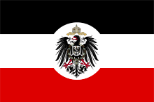
| Togoland Protectorate | ||||||||||
| Schutzgebiet Togo | ||||||||||
| Protectorate of German Empire | ||||||||||
| ||||||||||
| ||||||||||
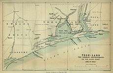
 Green: Territory comprising German colony of Togoland Dark grey: Other German possessions Darkest grey: German Empire Note: The map uses the borders of the present-day, but the historical extent for German territories are depicted. | ||||||||||
| Capital | Bagida (1884–87) Sebeab (1887–97) Lomé (1897–1916) | |||||||||
| Languages | German (official) Ewe, Kotokoli, Kabye | |||||||||
| Religion | Islam, Christianity, Akan religion, Traditional religion | |||||||||
| Political structure | Protectorate | |||||||||
| Historical era | New Imperialism | |||||||||
| • | Protectorate established | 5 July 1884 | ||||||||
| • | Allied occupation | 26 August 1914 | ||||||||
| • | Togoland partitioned | 27 December 1916 | ||||||||
| Area | ||||||||||
| • | 1913 | 77,355 km² (29,867 sq mi) | ||||||||
| Currency | German gold mark | |||||||||
| ||||||||||
| Today part of | | |||||||||
Togoland was a German protectorate in West Africa from 1884 to 1914, encompassing what is now the nation of Togo and most of what is now the Volta Region of Ghana, approximately 77,355 km² (29,867 sq mi) in size.[1][2] The colony was established during the period generally known as the "Scramble for Africa". The colony was established in 1884 in part of what was then the Slave Coast and was gradually extended inland. At the outbreak of the First World War in 1914 the colony was drawn into the conflict. It was invaded and quickly overrun by British and French forces during the Togoland campaign and placed under military rule. In 1916 the territory was divided into separate British and French administrative zones, and this was formalized in 1922 with the creation of British Togoland and French Togoland.
History
The colony was established towards the end of the period of European colonization in Africa generally known as the "Scramble for Africa". Two separate protectorates were established in 1884. In February 1884, the chiefs of the town of Aného were kidnapped by German soldiers and forced to sign a treaty of protection.[3] In the Lomé region, the German explorer, medical doctor, imperial consul and commissioner for West Africa Gustav Nachtigal was the driving force toward the establishment of the West African colonies of Togoland as well as Kamerun. From his base on the Spanish island possession Fernando Po in the Bight of Biafra he traveled extensively on the mainland of Africa. On 5 July 1884 Nachtigal signed a treaty with the local chief, Mlapa III, in which he declared a German protectorate over a stretch of territory along the Slave Coast on the Bight of Benin. With the small gunboat SMS Möwe at anchor, the imperial flag was raised for the first time on the African continent. Consul Heinrich Ludwig Randad, Jr., resident agent of the firm C. Goedelts at Widah, was appointed as the first commissioner for the territory.[4]
In 1899, Germany and Great Britain traded territory in the Samoan Islands for the Northern Solomon Islands and control in Tonga, using the Togoland Neutral Zone (Yendi) and the Volta Triangle as bargaining chips.[5]

Economics and growth
Germany gradually extended its control inland. Colonial administrators and settlers brought scientific cultivation to the country's main export crops (cacao, coffee, cotton). The total number of German officials in the colony was only 12 in 1890.[6] The colony’s infrastructure was developed to one of the highest levels in Africa. Colonial officials built roads and bridges to the interior mountain ranges and three rail lines from the capital Lomé; along the coast to Aného in 1905, to Palime (modern Kpalimé) in 1907, and the longest line, the Hinterlandbahn to Atakpamé by 1911.[7] By 1910, over 1,000 of roads were constructed by the colonial office.[6]
Organised in 1888 with 25 Hausa infantry, the Polizeitruppe was utilised in enforcing the colonial authority over the hinterland of Togo. Expanded to 144 members in 1894, operations against Kpandu and "a number of towns in central Togo which had resisted the government were attacked and razed to the ground, the property of the inhabitants confiscated and the people fined sums ranging from 200 marks to 1,110 marks."[6] For the remainder of the decade, an additional 35 expeditions were authorised by the colonial government.[6]
In 1895 the capital Lomé had a population of 31 Germans and 2,084 natives. By 1913 the native population had swelled to 7,042 persons and 194 Germans, including 33 women, while the entire colony had a German population of 316, including 61 women and 14 children.[8] In the years just before World War I, Lomé had grown into the “prettiest town in West Africa.”[9] Because it was one of Germany's two self-supporting colonies,[10] Togoland was acknowledged as a small but treasured possession. This would last until the eruption of World War I.
World War I occupation and beyond

After calling on the German colony to surrender on 6 August 1914, French and British troops invaded unopposed the next day. No military personnel were stationed in the protectorate. The police force consisted of a commander and deputy commander, 10 German sergeants, 1 native sergeant and 660 Togolese policemen deployed throughout the territory.[11] The Entente forces occupied the capital Lome, then advanced on a powerful and new radio station near Kamina (east of Atakpamé). The colony surrendered on 26 August 1914, after the German technicians who had built the radio installation now destroyed the station during the night of 24/25 August. In the weeks before the destruction, Kamerun, German Southwest Africa, German East Africa and 47 ships on the high seas were sent reports of Allied actions, as well as warnings of predicaments ahead.[12] On 27 December 1916, Togoland was separated into French and British administrative zones. After the end of World War I, newly established Czechoslovakia tried to acquire the colony, however this was not realized. Following the ratification of the Treaty of Versailles, on 20 July 1922, Togoland formally became a League of Nations Class B mandate divided into French Togoland and British Togoland, covering respectively about two-thirds and one-third of the territory.[13]
The British area of the former German colony was integrated into Ghana in 1957 following a May 1956 plebiscite where 58% of British-area residents voted in favour of joining Ghana upon its independence, rather than remaining under British-administered trusteeship. The French-ruled region became the Republic of Togo in 1960 and is now known as the Togolese Republic. In 1960, the new state invited the last German governor of Togoland, Duke Adolf Friedrich of Mecklenburg to the country’s official independence celebrations.
See also
- British Togoland
- French Togoland
- German East Africa
- German Kamerun
- German South-West Africa
- German West African Company
- Gold Coast (British colony)
- History of Togo
- List of colonial heads of German Togoland
- List of former German colonies
- Volta Region
Footnotes
- ↑ "Rank Order – Area". CIA World Fact Book. Retrieved 12 April 2008.
- ↑ David Owusu-Ansah. Historical Dictionary of Ghana (4 ed.). Rowman & Littlefield. p. xii.
- ↑ Laumann, "A Historiography of German Togoland", p. 195
- ↑ Washausen, Hamburg und die Kolonialpolitik, p. 79
- ↑ Paul M. Kennedy, "The Samoan Tangle: A Study in Anglo-German-American Relations, 1878-1900", Harper & Row, p 1974.
- ↑ Haupt,Deutschlands Schutzgebiete, p. 82
- ↑ Haupt, p. 81
- ↑ Haupt, p. 74
- ↑ German Samoa was self-sufficient after 1908
- ↑ Haupt, p. 79
- ↑ Haupt, p. 87
- ↑ Martin, Lawrence (2007). The treaties of peace, 1919-1923. 2. The Lawbook Exchange, Ltd. p. 15. ISBN 978-1-58477-708-3. Retrieved 19 July 2011.
References
- Haupt, Werner (1984). Deutschlands Schutzgebiete in Übersee 1884-1918. [Germany’s Overseas Protectorates 1884-1918]. Friedberg: Podzun-Pallas Verlag. ISBN 3-7909-0204-7.
- Laumann, Dennis (2003). "A Historiography of German Togoland, or the Rise and Fall of a "Model Colony"". History in Africa. 30: 195–211.
- Washausen, Helmut (1968). Hamburg und die Kolonialpolitik des Deutschen Reiches. [Hamburg and Colonial Politics of the German Empire]. Hamburg: Hans Christians Verlag.
External links
| Wikimedia Commons has media related to German colony of Togo. |
| Colonies |
| |||||||
|---|---|---|---|---|---|---|---|---|
| Concessions |
| |||||||
| Unrecognised |
| |||||||
Togo articles | |||
|---|---|---|---|
| History |  | ||
| Geography | |||
| Politics | |||
| Economy | |||
| Society | |||
| |||