Sainte-Florence, Quebec
| Sainte-Florence | |
|---|---|
| Municipality | |
 | |
| Motto: Travail, Foi, Honneur | |
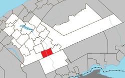 Location within La Matapédia RCM. | |
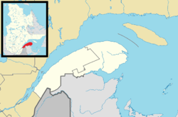 Sainte-Florence Location in eastern Quebec. | |
| Coordinates: 48°16′N 67°14′W / 48.267°N 67.233°WCoordinates: 48°16′N 67°14′W / 48.267°N 67.233°W[1] | |
| Country |
|
| Province |
|
| Region | Bas-Saint-Laurent |
| RCM | La Matapédia |
| Constituted | April 12, 1911 |
| Government[2] | |
| • Mayor | Gaston Martin |
| • Federal riding |
Haute-Gaspésie—La Mitis—Matane—Matapédia |
| • Prov. riding | Matane-Matapédia |
| Area[2][3] | |
| • Total | 102.60 km2 (39.61 sq mi) |
| • Land | 103.05 km2 (39.79 sq mi) |
|
There is an apparent contradiction between two authoritative sources | |
| Population (2011)[3] | |
| • Total | 414 |
| • Density | 4.0/km2 (10/sq mi) |
| • Pop 2006-2011 |
|
| • Dwellings | 215 |
| Time zone | EST (UTC−5) |
| • Summer (DST) | EDT (UTC−4) |
| Postal code(s) | G0J 2M0 |
| Area code(s) | 418 and 581 |
| Highways |
|
| Website |
www |
Sainte-Florence is a Canadian forestry village in the province of Quebec, located in the Matapédia Valley in the Gaspé Peninsula.
The municipality had a population of 414 as of the Canada 2011 Census.
Municipal council
- Mayor: Réjeanne Doiron
- Councillors: Pierrette Bérubé, Lauraine Gendron, Nelson Barrest, Henri Lafrance, Carol Poitras, France Lepage
Demographics
Population
| Canada census – Sainte-Florence, Quebec community profile | |||
|---|---|---|---|
| 2011 | 2006 | 2001 | |
| Population: | 414 (-9.6% from 2006) | 458 (-3.2% from 2001) | 473 (-13.4% from 1996) |
| Land area: | 103.05 km2 (39.79 sq mi) | 103.05 km2 (39.79 sq mi) | 103.05 km2 (39.79 sq mi) |
| Population density: | 4.0/km2 (10/sq mi) | 4.4/km2 (11/sq mi) | 4.6/km2 (12/sq mi) |
| Median age: | 54.0 (M: 53.5, F: 54.2) | 49.7 (M: 50.7, F: 49.3) | 44.0 (M: 45.0, F: 42.9) |
| Total private dwellings: | 215 | 225 | 212 |
| Median household income: | $.N/A | $29,649 | $34,619 |
| Notes: 2011 income data suppressed to meet the confidentiality requirements of the Statistics Act. Population in 1996: 546[4] (-2.0% from 1991) - Population in 1991: 557[4] – References: 2011[3] 2006[5] 2001[6] | |||
See also
References
- ↑ Reference number 56172 of the Commission de toponymie du Québec (French)
- 1 2 "Sainte-Florence". Répertoire des municipalités (in French). Ministère des Affaires municipales, des Régions et de l'Occupation du territoire. Retrieved 2012-02-01.
- 1 2 3 "Sainte-Florence census profile". 2011 Census data. Statistics Canada. Retrieved 2012-02-01.
- 1 2 "Electronic Area Profiles". Canada 1996 Census. Statistics Canada. Retrieved 2013-05-12.
- ↑ "2006 Community Profiles". Canada 2006 Census. Statistics Canada. March 30, 2011. Retrieved 2012-02-01.
- ↑ "2001 Community Profiles". Canada 2001 Census. Statistics Canada. February 17, 2012. Retrieved 2012-02-01.
 |
Albertville | Causapscal | | |
| Rivière-Vaseuse | |
Sainte-Marguerite-Marie | ||
| ||||
| | ||||
| Routhierville |
| Cities & Towns | |
|---|---|
| Municipalities | |
| Parishes | |
| Villages | |
| Unorganized territories | |
| |
This article is issued from Wikipedia - version of the 11/17/2016. The text is available under the Creative Commons Attribution/Share Alike but additional terms may apply for the media files.