Roucy
| Roucy | ||
|---|---|---|
|
The square in Roucy | ||
| ||
 Roucy | ||
|
Location within Hauts-de-France region  Roucy | ||
| Coordinates: 49°22′22″N 3°48′57″E / 49.3728°N 3.8158°ECoordinates: 49°22′22″N 3°48′57″E / 49.3728°N 3.8158°E | ||
| Country | France | |
| Region | Hauts-de-France | |
| Department | Aisne | |
| Arrondissement | Laon | |
| Canton | Neufchâtel-sur-Aisne | |
| Intercommunality | Champagne Picarde | |
| Government | ||
| • Mayor (2008–2014) | Pascale Garcia | |
| Area1 | 6.96 km2 (2.69 sq mi) | |
| Population (2012)2 | 390 | |
| • Density | 56/km2 (150/sq mi) | |
| Time zone | CET (UTC+1) | |
| • Summer (DST) | CEST (UTC+2) | |
| INSEE/Postal code | 02656 / 02160 | |
| Elevation |
55–206 m (180–676 ft) (avg. 100 m or 330 ft) | |
|
1 French Land Register data, which excludes lakes, ponds, glaciers > 1 km² (0.386 sq mi or 247 acres) and river estuaries. 2 Population without double counting: residents of multiple communes (e.g., students and military personnel) only counted once. | ||
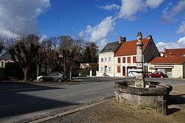

Roucy is a small commune in the Aisne department in Hauts-de-France in northern France.Notable features of this town include the wide central plaza which village fetes occur every summer.
Population
| Historical population | ||
|---|---|---|
| Year | Pop. | ±% |
| 1962 | 253 | — |
| 1968 | 223 | −11.9% |
| 1975 | 249 | +11.7% |
| 1982 | 293 | +17.7% |
| 1990 | 281 | −4.1% |
| 1999 | 329 | +17.1% |
| 2008 | 404 | +22.8% |
| 2012 | 390 | −3.5% |
See also
References
| Wikimedia Commons has media related to Roucy. |
This article is issued from Wikipedia - version of the 11/8/2016. The text is available under the Creative Commons Attribution/Share Alike but additional terms may apply for the media files.