Chaudun
| Chaudun | |
|---|---|
|
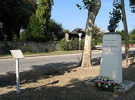
Monument to a dead soldier, the son of French politician Jean Jaurès | |
 Chaudun | |
|
Location within Hauts-de-France region  Chaudun | |
| Coordinates: 49°19′07″N 3°15′55″E / 49.3186°N 3.2653°ECoordinates: 49°19′07″N 3°15′55″E / 49.3186°N 3.2653°E | |
| Country | France |
| Region | Hauts-de-France |
| Department | Aisne |
| Arrondissement | Soissons |
| Canton | Oulchy-le-Château |
| Intercommunality | Oulchy le Château |
| Government | |
| • Mayor (2008–2014) | Philippe du Roizel |
| Area1 | 8.52 km2 (3.29 sq mi) |
| Population (2008)2 | 260 |
| • Density | 31/km2 (79/sq mi) |
| Time zone | CET (UTC+1) |
| • Summer (DST) | CEST (UTC+2) |
| INSEE/Postal code | 02172 / 02200 |
| Elevation |
105–157 m (344–515 ft) (avg. 152 m or 499 ft) |
|
1 French Land Register data, which excludes lakes, ponds, glaciers > 1 km² (0.386 sq mi or 247 acres) and river estuaries. 2 Population without double counting: residents of multiple communes (e.g., students and military personnel) only counted once. | |
Chaudun is a commune in the department of Aisne in Hauts-de-France in northern France.
Population
| Historical population | ||
|---|---|---|
| Year | Pop. | ±% |
| 1962 | 222 | — |
| 1968 | 234 | +5.4% |
| 1975 | 294 | +25.6% |
| 1982 | 257 | −12.6% |
| 1990 | 287 | +11.7% |
| 1999 | 282 | −1.7% |
| 2008 | 260 | −7.8% |
See also
References
| Wikimedia Commons has media related to Chaudun. |
This article is issued from Wikipedia - version of the 11/8/2016. The text is available under the Creative Commons Attribution/Share Alike but additional terms may apply for the media files.