Perruel
| Perruel | ||
|---|---|---|
 | ||
| ||
 Perruel | ||
|
Location within Normandy region  Perruel | ||
| Coordinates: 49°25′45″N 1°22′33″E / 49.4292°N 1.3758°ECoordinates: 49°25′45″N 1°22′33″E / 49.4292°N 1.3758°E | ||
| Country | France | |
| Region | Normandy | |
| Department | Eure | |
| Arrondissement | Les Andelys | |
| Canton | Fleury-sur-Andelle | |
| Intercommunality | L'Andelle | |
| Government | ||
| • Mayor (2008–2014) | Claude Philippe | |
| Area1 | 5.37 km2 (2.07 sq mi) | |
| Population (2008)2 | 453 | |
| • Density | 84/km2 (220/sq mi) | |
| Time zone | CET (UTC+1) | |
| • Summer (DST) | CEST (UTC+2) | |
| INSEE/Postal code | 27454 / 27910 | |
| Elevation |
46–143 m (151–469 ft) (avg. 54 m or 177 ft) | |
|
1 French Land Register data, which excludes lakes, ponds, glaciers > 1 km² (0.386 sq mi or 247 acres) and river estuaries. 2 Population without double counting: residents of multiple communes (e.g., students and military personnel) only counted once. | ||

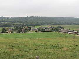
Perruel is a commune in the Eure department in Haute-Normandie in northern France.
The village shelters the ancient abbey of Isle-Dieu, today a farm on the road between Perruel and Vascoeuil.
Population
| Historical population | ||
|---|---|---|
| Year | Pop. | ±% |
| 1962 | 266 | — |
| 1968 | 310 | +16.5% |
| 1975 | 333 | +7.4% |
| 1982 | 372 | +11.7% |
| 1990 | 355 | −4.6% |
| 1999 | 401 | +13.0% |
| 2008 | 453 | +13.0% |
See also
References
| Wikimedia Commons has media related to Perruel. |
This article is issued from Wikipedia - version of the 2/11/2016. The text is available under the Creative Commons Attribution/Share Alike but additional terms may apply for the media files.