Conches-en-Ouche
| Conches-en-Ouche | ||
|---|---|---|
 | ||
| ||
 Conches-en-Ouche | ||
|
Location within Normandy region  Conches-en-Ouche | ||
| Coordinates: 48°57′41″N 0°56′36″E / 48.9614°N 0.9433°ECoordinates: 48°57′41″N 0°56′36″E / 48.9614°N 0.9433°E | ||
| Country | France | |
| Region | Normandy | |
| Department | Eure | |
| Arrondissement | Évreux | |
| Canton | Conches-en-Ouche | |
| Intercommunality | Pays de Conches | |
| Government | ||
| • Mayor (2008–2014) | Alfred Recours | |
| Area1 | 16.72 km2 (6.46 sq mi) | |
| Population (2008)2 | 5,034 | |
| • Density | 300/km2 (780/sq mi) | |
| Time zone | CET (UTC+1) | |
| • Summer (DST) | CEST (UTC+2) | |
| INSEE/Postal code | 27165 / 27190 | |
| Elevation |
100–173 m (328–568 ft) (avg. 123 m or 404 ft) | |
|
1 French Land Register data, which excludes lakes, ponds, glaciers > 1 km² (0.386 sq mi or 247 acres) and river estuaries. 2 Population without double counting: residents of multiple communes (e.g., students and military personnel) only counted once. | ||
.svg.png)
Conches-en-Ouches is a commune in the Eure département in northern France.
Geography
It is located by the Rouloir river, southwest of Évreux in the Haute-Normandie region. The town is located on a plateau known as the Pays d'Ouche.
Population
| Historical population | ||
|---|---|---|
| Year | Pop. | ±% |
| 1882 | 2,105 | — |
| 1962 | 3,028 | +43.8% |
| 1968 | 3,534 | +16.7% |
| 1975 | 3,785 | +7.1% |
| 1982 | 3,854 | +1.8% |
| 1990 | 4,009 | +4.0% |
| 1999 | 4,280 | +6.8% |
| 2008 | 5,034 | +17.6% |
Sights and monuments
- Château de Conches-en-Ouche, ruins of 11th-century castle
- L'église Sainte-Foy
- Abbaye Saint-Pierre et Saint-Paul de Châtillon-lès-Conches
- Arboretum
- Folk museum
Personalities linked to the commune
- Guillaume de Conches, medieval grammarian, philosopher and theologian linked to the School of Chartres.
- Diderot set an episode of Jacques le fataliste et son maître (1773/1775) in Conches.
- Victor-Amédée Barbié du Bocage (1832-1890), renowned geographer and essayist, died in the Château de Quenet on 11 October 1890.
- François Décorchemont (1880-1971), master glassmaker who made the windows of numerous churches in the Eure and the Church of Sainte-Odile in Paris was born and died in Conches.
- Alfred Recours, mayor of the town since 1984 and a former deputy for l'Eure.
International relations
Twin towns — Sister cities
Conches-en-Ouche is twinned with:
See also
Gallery
 Gargoyles on Sainte-Foy
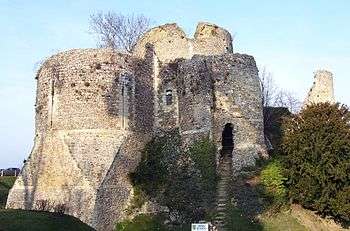 Keep (donjon) built 1035 by Roger I of Tosny and destroyed 1591 in the French Wars of Religion
 Abbey (11th century) and hospital
References
- ↑ "Twinnings" (PDF). Central Union of Municipalities & Communities of Greece. Retrieved 2013-08-25.
- ↑ "British towns twinned with French towns [via WaybackMachine.com]". Archant Community Media Ltd. Archived from the original on 5 July 2013. Retrieved 2013-07-20.
| Wikimedia Commons has media related to Conches-en-Ouche. |
This article is issued from Wikipedia - version of the 9/5/2016. The text is available under the Creative Commons Attribution/Share Alike but additional terms may apply for the media files.