Tilly, Eure
| Tilly | ||
|---|---|---|
|
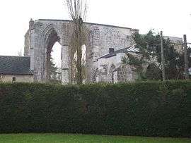
Ruins of the priory of Salseuse | ||
| ||
 Tilly | ||
|
Location within Normandy region  Tilly | ||
| Coordinates: 49°08′45″N 1°31′43″E / 49.1458°N 1.5286°ECoordinates: 49°08′45″N 1°31′43″E / 49.1458°N 1.5286°E | ||
| Country | France | |
| Region | Normandy | |
| Department | Eure | |
| Arrondissement | Les Andelys | |
| Canton | Écos | |
| Intercommunality | Epte-Vexin-Seine | |
| Government | ||
| • Mayor (2008–2014) | Patrick Jourdain | |
| Area1 | 12.19 km2 (4.71 sq mi) | |
| Population (2008)2 | 554 | |
| • Density | 45/km2 (120/sq mi) | |
| Time zone | CET (UTC+1) | |
| • Summer (DST) | CEST (UTC+2) | |
| INSEE/Postal code | 27644 / 27510 | |
| Elevation |
50–156 m (164–512 ft) (avg. 144 m or 472 ft) | |
|
1 French Land Register data, which excludes lakes, ponds, glaciers > 1 km² (0.386 sq mi or 247 acres) and river estuaries. 2 Population without double counting: residents of multiple communes (e.g., students and military personnel) only counted once. | ||

Tilly is a commune in the Eure department in Haute-Normandie in northern France.
Population
| Historical population | ||
|---|---|---|
| Year | Pop. | ±% |
| 1793 | 408 | — |
| 1800 | 413 | +1.2% |
| 1806 | 438 | +6.1% |
| 1821 | 410 | −6.4% |
| 1831 | 416 | +1.5% |
| 1836 | 423 | +1.7% |
| 1841 | 401 | −5.2% |
| 1846 | 405 | +1.0% |
| 1851 | 380 | −6.2% |
| 1856 | 360 | −5.3% |
| 1861 | 336 | −6.7% |
| 1866 | 360 | +7.1% |
| 1872 | 319 | −11.4% |
| 1876 | 322 | +0.9% |
| 1881 | 331 | +2.8% |
| 1886 | 332 | +0.3% |
| 1891 | 329 | −0.9% |
| 1896 | 305 | −7.3% |
| 1901 | 338 | +10.8% |
| 1906 | 298 | −11.8% |
| 1911 | 301 | +1.0% |
| 1921 | 273 | −9.3% |
| 1926 | 261 | −4.4% |
| 1931 | 286 | +9.6% |
| 1936 | 264 | −7.7% |
| 1946 | 277 | +4.9% |
| 1954 | 255 | −7.9% |
| 1962 | 255 | +0.0% |
| 1968 | 239 | −6.3% |
| 1975 | 270 | +13.0% |
| 1982 | 383 | +41.9% |
| 1990 | 457 | +19.3% |
| 1999 | 457 | +0.0% |
| 2008 | 554 | +21.2% |
See also
References
| Wikimedia Commons has media related to Tilly (Eure). |
This article is issued from Wikipedia - version of the 3/15/2016. The text is available under the Creative Commons Attribution/Share Alike but additional terms may apply for the media files.