Paysandú
| Paysandú | |
|---|---|
| Capital city | |
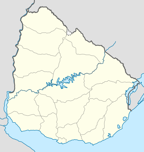 Paysandú Location in Uruguay | |
| Coordinates: 32°19′17″S 58°4′32″W / 32.32139°S 58.07556°WCoordinates: 32°19′17″S 58°4′32″W / 32.32139°S 58.07556°W | |
| Country |
|
| Department | Paysandú Department |
| Founded | 1756 |
| Elevation | 34 m (112 ft) |
| Population (2011) | |
| • Total | 76,412 |
| Time zone | UTC -3 |
| Postal code | 60000 |
| Dial plan | +598 472 (+5 digits) |
| Climate | Cfa |
Paysandú is the capital of Paysandú Department in western Uruguay.
Location
The city is located on the banks of Uruguay River, which forms the border with Argentina. It lies 378 kilometres (235 mi) northwest of Montevideo via Route 1 and Route 3, on the junction of the latter with Route 90. As of the census of 2011, it is the fourth most populated city of the country.
A small distance north of the city is the General Artigas Bridge that links Uruguay with the Entre Ríos Province of Argentina, south of the city Colón.[1]
History
It was founded on October 1756 and had acquired the status of "Villa" (town) before the Independence of Uruguay. On 8 June 1863, its status was elevated to "Ciudad" (city) by the Act of Ley Nº 780.[2]
General Leandro Gomez led Uruguayan forces to save the town from an invasion by Brazilian forces in 1864-5. A battle took place on 2 December 1864.[3]
Population
In 2011 Paysandú had a population of 76,412.[4] It is the fourth largest city in Uruguay, after Montevideo, Salto and Ciudad de la Costa.
| Year | Population |
|---|---|
| 1908 | 20,953 |
| 1963 | 51,645 |
| 1975 | 62,199 |
| 1985 | 68,466 |
| 1996 | 74,568 |
| 2004 | 73,292 |
| 2011 | 76,412 |
Source: Instituto Nacional de Estadística de Uruguay[2]
Paysandú is more cosmopolitan than most Uruguayan cities, with many settlers from Italy, Switzerland, Poland, Germany, Russia, Ukraine, Belgium and various African nations.
Climate
Paysandú has a humid subtropical climate, described by the Köppen climate classification as Cfa. Summers are warm to hot and winters are cool, with the occurrence of frosts and fog. The precipitation is evenly distributed throughout the year, with an average of 1,181 mm (46.5 in), and the annual average temperature is around 19 °C (66 °F).
| Climate data for Paysandú, Uruguay | |||||||||||||
|---|---|---|---|---|---|---|---|---|---|---|---|---|---|
| Month | Jan | Feb | Mar | Apr | May | Jun | Jul | Aug | Sep | Oct | Nov | Dec | Year |
| Record high °C (°F) | 44.0 (111.2) |
42.4 (108.3) |
39.4 (102.9) |
36.0 (96.8) |
33.0 (91.4) |
29.2 (84.6) |
30.6 (87.1) |
32.8 (91) |
36.4 (97.5) |
38.0 (100.4) |
41.5 (106.7) |
41.9 (107.4) |
44.0 (111.2) |
| Average high °C (°F) | 31.5 (88.7) |
30.0 (86) |
27.6 (81.7) |
23.9 (75) |
20.4 (68.7) |
16.8 (62.2) |
16.9 (62.4) |
18.5 (65.3) |
20.5 (68.9) |
23.5 (74.3) |
26.4 (79.5) |
29.7 (85.5) |
23.8 (74.8) |
| Daily mean °C (°F) | 24.8 (76.6) |
23.7 (74.7) |
21.6 (70.9) |
18.0 (64.4) |
14.8 (58.6) |
11.7 (53.1) |
11.8 (53.2) |
12.9 (55.2) |
14.6 (58.3) |
17.5 (63.5) |
20.4 (68.7) |
23.1 (73.6) |
17.9 (64.2) |
| Average low °C (°F) | 18.3 (64.9) |
17.6 (63.7) |
15.7 (60.3) |
12.5 (54.5) |
9.6 (49.3) |
6.9 (44.4) |
7.1 (44.8) |
7.5 (45.5) |
8.8 (47.8) |
11.6 (52.9) |
14.1 (57.4) |
16.8 (62.2) |
12.2 (54) |
| Record low °C (°F) | 7.8 (46) |
3.2 (37.8) |
3.2 (37.8) |
0.0 (32) |
−2.6 (27.3) |
−7.4 (18.7) |
−6.6 (20.1) |
−4.0 (24.8) |
−3.4 (25.9) |
0.6 (33.1) |
2.3 (36.1) |
4.8 (40.6) |
−7.4 (18.7) |
| Average precipitation mm (inches) | 100 (3.94) |
131 (5.16) |
147 (5.79) |
103 (4.06) |
77 (3.03) |
70 (2.76) |
71 (2.8) |
73 (2.87) |
91 (3.58) |
122 (4.8) |
118 (4.65) |
115 (4.53) |
1,218 (47.95) |
| Average precipitation days (≥ 1.0 mm) | 6 | 6 | 7 | 6 | 6 | 5 | 6 | 5 | 6 | 7 | 6 | 6 | 72 |
| Average relative humidity (%) | 65 | 69 | 72 | 75 | 77 | 80 | 79 | 75 | 73 | 72 | 69 | 66 | 73 |
| Mean monthly sunshine hours | 287.8 | 222.6 | 233.5 | 198.6 | 183.8 | 149.0 | 167.2 | 183.6 | 203.1 | 244.0 | 258.6 | 289.8 | 2,621.6 |
| Source: Dirección Nacional de Meteorología (extremes 1937–1994)[5][6] | |||||||||||||
Economy
The main industries in the city are Norteña brewery, Azucarlito (sugar), Paylana (which is a producer of world-class woolen fabrics), and Paycuero (leather). Paysandú is also the centre of plantation forest industry in Uruguay, with many companies involved in the planting and harvesting of Eucalyptus plantations.[7]

Transportation
The city is served by Tydeo Larre Borges International Airport.
Recreation
Paysandú has some fine recreational beaches on the Uruguay River which have lifeguards during the summer. It is also home to many sporting clubs, including a rowing club, yacht club, and numerous others for football, rugby, hockey, tennis and polo.
Education
Previously the area had a German school, Deutsche Schule Paysandú.[8]
Places of worship
- Parish Church of Our Lady of the Rosary and St. Benedict of Palermo (Roman Catholic)
- St. Raymond and St. John Bosco Parish Church (Roman Catholic, Salesians of Don Bosco)
- Sacred Heart of Jesus Parish Church (Roman Catholic)
- St. Joseph the Worker Parish Church (Roman Catholic)
Notable people
Politicians
- Reinaldo Gargano (FA), Foreign Minister of Uruguay (2005–2008) †
- Jorge Larrañaga (PN), current Senator
- Raúl Sendic (FA), current Vice-President of Uruguay
Football players
- Sebastián Soria, Qatari football player
- Walter Gargano, football player of SSC Napoli
- Nicolás Lodeiro, football player of Seattle Sounders FC
- Bosco Frontán, football player of Peñarol
- Egidio Arévalo Rios, football player of Tigres UANL
Musicians
Other
- Clotilde Luisi (1882-1969), first woman to study law at the University of the Republic
Twinned cities
 Hellín, Spain
 Muscatine, Iowa, United States
 Smara, Western Sahara[9]
See also
References
- ↑ Leitner, Gerry (January 2001). Argentina Travel Companion. Hunter Publishing, Inc. p. 936. ISBN 978-0-9587498-1-7. Retrieved 30 May 2011.
- 1 2 "Statistics of urban localities (1908–2004)" (PDF). INE. 2012. Retrieved 4 September 2012.
- ↑ Marley, David (February 2008). Wars of the Americas: a chronology of armed conflict in the Western Hemisphere, 1492 to the present. ABC-CLIO. p. 855. ISBN 978-1-59884-100-8. Retrieved 30 May 2011.
- ↑ "Censos 2011 Cuadros Paysandú". INE. 2012. Retrieved 25 August 2012.
- ↑ "Estadísticas climatológicas" (in Spanish). Dirección Nacional de Meteorología. Retrieved 22 October 2012.
- ↑ "RECORDS METEOROLOGICOS EN EL URUGUAY" (in Spanish). Dirección Nacional de Meteorología. Retrieved April 30, 2014.
- ↑ Bouton, Lawrence (1998). The private sector and development: five case studies. World Bank Publications. p. 42. ISBN 978-0-8213-4199-5. Retrieved 30 May 2011.
- ↑ "Deutscher Bundestag 4. Wahlperiode Drucksache IV/3672" (Archive). Bundestag (West Germany). 23 June 1965. Retrieved on 12 March 2016. p. 29/51.
- ↑ "Sign of twining agreement between Wilaya of Smara and city of Paysandú". Sahara Press Service. 2011-10-24. Retrieved 2011-10-27.
External links
| Wikimedia Commons has media related to Paysandú. |
- Paysandú Portal
- Tourist information for nearby Thermal Baths of Guaviú and Almirón
- INE map of Paysandú and San Félix
Capital: Paysandú | ||
| Towns and villages | 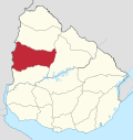 | |
| Sights | ||