National Register of Historic Places listings in Marshall County, Kansas

Location of Marshall County in Kansas
This is a list of the National Register of Historic Places listings in Marshall County, Kansas.
This is intended to be a complete list of the properties and districts on the National Register of Historic Places in Marshall County, Kansas, United States. The locations of National Register properties and districts for which the latitude and longitude coordinates are included below, may be seen in a map.[1]
There are 21 properties and districts listed on the National Register in the county.
- This National Park Service list is complete through NPS recent listings posted December 16, 2016.[2]
Current listings
| [3] | Name on the Register[4] | Image | Date listed[5] | Location | City or town | Description |
|---|---|---|---|---|---|---|
| 1 | Alcove Springs | Upload image | (#72000513) |
4 miles (6.4 km) north of Blue Rapids; E. River Rd 39°44′56″N 96°40′35″W / 39.748889°N 96.676389°W |
Blue Rapids | Boundary increase September 25, 2013 |
| 2 | Barrett Schoolhouse | Upload image | (#73000766) |
4 miles (6.4 km) southwest of Frankfort on K-99 39°39′59″N 96°27′06″W / 39.666389°N 96.451667°W |
Frankfort | |
| 3 | Blue Rapids Library | Upload image | (#72000514) |
Eastern side of the public square 39°40′55″N 96°39′29″W / 39.681944°N 96.658056°W |
Blue Rapids | |
| 4 | Frankfort School | Upload image | (#72000515) |
400 Locust St. 39°42′17″N 96°25′01″W / 39.704722°N 96.416944°W |
Frankfort | |
| 5 | Perry Hutchinson House | _from_NE_1.JPG) |
(#72000516) |
1 mile (1.6 km) northwest of Marysville on U.S. Route 77 39°51′02″N 96°40′02″W / 39.850521°N 96.667222°W |
Marysville | |
| 6 | Koester Block Historic District | .jpg) |
(#80001469) |
Between 9th, 10th, Elm, and Broadway Sts. 39°50′29″N 96°38′44″W / 39.841389°N 96.645556°W |
Marysville | |
| 7 | Charles Koester House | 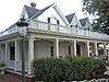 |
(#75000715) |
919 Broadway 39°50′29″N 96°38′44″W / 39.841389°N 96.645556°W |
Marysville | |
| 8 | Marshall County Courthouse |  |
(#74000843) |
1207 Broadway 39°50′32″N 96°38′31″W / 39.842222°N 96.641944°W |
Marysville | |
| 9 | Marysville High School-Junior High School Complex | 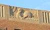 |
(#12001120) |
1011-1111 Walnut St. 39°50′23″N 96°38′41″W / 39.839609°N 96.644788°W |
Marysville | |
| 10 | Marysville Pony Express Barn | 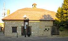 |
(#73000767) |
108 S. 8th St. 39°50′27″N 96°38′51″W / 39.840833°N 96.6475°W |
Marysville | |
| 11 | Marysville Union Pacific Depot | Upload image | (#16000709) |
000 Hedrix Ave. (at Alston St.) 39°50′39″N 96°38′56″W / 39.844173°N 96.649004°W |
Marysville | |
| 12 | Z. H. Moore Store | Upload image | (#76000830) |
State and Center Sts. 39°57′53″N 96°36′01″W / 39.964722°N 96.600278°W |
Oketo | |
| 13 | Old Frankfort City Jail | Upload image | (#82000418) |
Railway Ave. 39°42′05″N 96°25′02″W / 39.701389°N 96.417222°W |
Frankfort | |
| 14 | Oregon and California Trail--Pacha Ruts | Upload image | (#13001040) |
Address Restricted |
Bremen vicinity | |
| 15 | Samuel Powell House | Upload image | (#72000517) |
108 W. Commercial St. 39°41′33″N 96°44′17″W / 39.6925°N 96.738056°W |
Waterville | |
| 16 | Pusch-Randell House | .jpg) |
(#86002680) |
1000 Elm St. 39°50′30″N 96°38′48″W / 39.841667°N 96.646667°W |
Marysville | |
| 17 | Robidoux Creek Pratt Truss Bridge | Upload image | (#03000474) |
Sunflower Rd., 0.8 miles (1.3 km) west of its junction with 21st Rd., northwest of Frankfort 39°43′33″N 96°26′26″W / 39.725833°N 96.440556°W |
Frankfort | |
| 18 | St. Bridget Church | Upload image | (#96001011) |
Rural Route 2, 6.5 miles (10.5 km) north of Axtell 39°57′58″N 96°15′48″W / 39.966111°N 96.263333°W |
St. Bridget Township | |
| 19 | Transue Brothers Blacksmith & Wagon Shop | Upload image | (#09001164) |
309 Main St. 39°59′54″N 96°20′55″W / 39.998344°N 96.348558°W |
Summerfield | |
| 20 | Waterville Opera House | 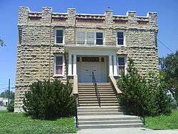 |
(#08000984) |
200 E. Front St. 39°41′29″N 96°44′51″W / 39.691389°N 96.7475°W |
Waterville | |
| 21 | Weaver Hotel |  |
(#75000716) |
126 S. Kansas St. 39°41′30″N 96°44′51″W / 39.691667°N 96.7475°W |
Waterville |
See also
| Wikimedia Commons has media related to National Register of Historic Places in Marshall County, Kansas. |
- List of National Historic Landmarks in Kansas
- National Register of Historic Places listings in Kansas
References
- ↑ The latitude and longitude information provided in this table was derived originally from the National Register Information System, which has been found to be fairly accurate for about 99% of listings. For about 1% of NRIS original coordinates, experience has shown that one or both coordinates are typos or otherwise extremely far off; some corrections may have been made. A more subtle problem causes many locations to be off by up to 150 yards, depending on location in the country: most NRIS coordinates were derived from tracing out latitude and longitudes off of USGS topographical quadrant maps created under the North American Datum of 1927, which differs from the current, highly accurate WGS84 GPS system used by most on-line maps. Chicago is about right, but NRIS longitudes in Washington are higher by about 4.5 seconds, and are lower by about 2.0 seconds in Maine. Latitudes differ by about 1.0 second in Florida. Some locations in this table may have been corrected to current GPS standards.
- ↑ "National Register of Historic Places: Weekly List Actions". National Park Service, United States Department of the Interior. Retrieved on December 16, 2016.
- ↑ Numbers represent an ordering by significant words. Various colorings, defined here, differentiate National Historic Landmarks and historic districts from other NRHP buildings, structures, sites or objects.
- ↑ National Park Service (2009-03-13). "National Register Information System". National Register of Historic Places. National Park Service.
- ↑ The eight-digit number below each date is the number assigned to each location in the National Register Information System database, which can be viewed by clicking the number.

Municipalities and communities of Marshall County, Kansas, United States | ||
|---|---|---|
| Cities | | |
| CDP | ||
| Unincorporated communities | ||
| Ghost towns | ||
| Townships | ||
This article is issued from Wikipedia - version of the 10/23/2016. The text is available under the Creative Commons Attribution/Share Alike but additional terms may apply for the media files.