National Register of Historic Places listings in Pottawatomie County, Kansas
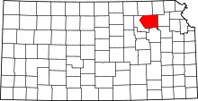
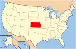
Location of Pottawatomie County in Kansas
This is a list of the National Register of Historic Places listings in Pottawatomie County, Kansas.
This is intended to be a complete list of the properties and districts on the National Register of Historic Places in Pottawatomie County, Kansas, United States. The locations of National Register properties and districts for which the latitude and longitude coordinates are included below, may be seen in a map.[1]
There are 14 properties and districts listed on the National Register in the county.
- This National Park Service list is complete through NPS recent listings posted December 16, 2016.[2]
Current listings
| [3] | Name on the Register[4] | Image | Date listed[5] | Location | City or town | Description |
|---|---|---|---|---|---|---|
| 1 | Cassius & Adelia Baker House | 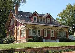 |
(#13000433) |
609 Elm Street 39°12′15″N 96°18′24″W / 39.20408°N 96.30679°W |
Wamego | |
| 2 | Coffey Site | Upload image | (#77000594) |
West of Spring Creek Rd. along the Big Blue River and Spring Creek[6] 39°33′52″N 96°34′03″W / 39.564444°N 96.567500°W |
Olsburg | |
| 3 | Dennis Quarry | Upload image | (#03001393) |
Along K-63 near the headwaters of Little Noxie Creek, southeast of Onaga[7] 39°25′32″N 96°04′45″W / 39.4255°N 96.0792°W |
Lincoln Township | |
| 4 | Joseph Heptig Barn | 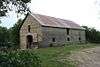 |
(#11000728) |
12115 Antons Rd. 39°16′24″N 96°26′03″W / 39.273333°N 96.434167°W |
Flush | Agriculture-Related Resources of Kansas MPS |
| 5 | John McKimmons Barn | Upload image | (#10000178) |
Kansas Highway 99, 1/4 mile south of Westmoreland or 1/2 mile north of Hartwich Rd 39°23′00″N 96°24′21″W / 39.383208°N 96.405858°W |
Westmoreland | |
| 6 | Old Dutch Mill |  |
(#73000773) |
Wamego City Park 39°12′06″N 96°18′03″W / 39.201667°N 96.300833°W |
Wamego | |
| 7 | Pottawatomie County Fair Pavilion | 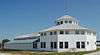 |
(#03001499) |
E. 9th St. 39°29′50″N 96°10′04″W / 39.497183°N 96.167781°W |
Onaga | |
| 8 | Pottawatomie Indian Pay Station | 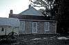 |
(#72000521) |
East of city limits on Mission St., near St. Mary's College campus 39°11′30″N 96°03′42″W / 39.191667°N 96.061667°W |
St. Marys | |
| 9 | Scott Spring |  |
(#13000762) |
Address restricted |
Westmoreland | |
| 10 | Teske Farmstead | Upload image | (#09000193) |
20795 Major Jenkins Road 39°30′28″N 96°14′20″W / 39.507778°N 96.238889°W |
Onaga | Agriculture-Related Resources of Kansas MPS |
| 11 | George and Virginia Trout House | 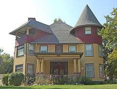 |
(#13001043) |
615 Elm St. 39°12′16″N 96°18′23″W / 39.204443°N 96.306491°W |
Wamego | |
| 12 | Vermillion Creek Archeological District | |
(#75000721) |
Address restricted |
Onaga | |
| 13 | Vermillion Creek Crossing, Oregon Trail | 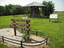 |
(#75000720) |
Northwest of Belvue 39°15′21″N 96°14′54″W / 39.255833°N 96.248333°W |
Belvue | A 20-acre (81,000 m2) property including a ford of the Oregon Trail across Vermillion Creek, and a cemetery |
| 14 | Vermillion Creek Tributary Stone Arch Bridge |  |
(#86003354) |
5 miles (8.0 km) south and 1 mile (1.6 km) east of Onaga 39°25′10″N 96°08′45″W / 39.419444°N 96.145833°W |
Onaga |
See also
| Wikimedia Commons has media related to National Register of Historic Places in Pottawatomie County, Kansas. |
- List of National Historic Landmarks in Kansas
- National Register of Historic Places listings in Kansas
References
- ↑ The latitude and longitude information provided in this table was derived originally from the National Register Information System, which has been found to be fairly accurate for about 99% of listings. For about 1% of NRIS original coordinates, experience has shown that one or both coordinates are typos or otherwise extremely far off; some corrections may have been made. A more subtle problem causes many locations to be off by up to 150 yards, depending on location in the country: most NRIS coordinates were derived from tracing out latitude and longitudes off of USGS topographical quadrant maps created under the North American Datum of 1927, which differs from the current, highly accurate WGS84 GPS system used by most on-line maps. Chicago is about right, but NRIS longitudes in Washington are higher by about 4.5 seconds, and are lower by about 2.0 seconds in Maine. Latitudes differ by about 1.0 second in Florida. Some locations in this table may have been corrected to current GPS standards.
- ↑ "National Register of Historic Places: Weekly List Actions". National Park Service, United States Department of the Interior. Retrieved on December 16, 2016.
- ↑ Numbers represent an ordering by significant words. Various colorings, defined here, differentiate National Historic Landmarks and historic districts from other NRHP buildings, structures, sites or objects.
- ↑ National Park Service (2009-03-13). "National Register Information System". National Register of Historic Places. National Park Service.
- ↑ The eight-digit number below each date is the number assigned to each location in the National Register Information System database, which can be viewed by clicking the number.
- ↑ Schmits, Larry J. "The Coffey Site: Environment and Cultural Adaptation at a Prairie Plains Archaic Site". Midcontinental Journal of Archaeology 3.1 (1978): 69-185: 79.
- ↑ Location derived from its NRHP nomination form; the NRIS lists the site as "Address Restricted"

Municipalities and communities of Pottawatomie County, Kansas, United States | ||
|---|---|---|
| Cities | | |
| Unincorporated communities | ||
| Footnotes | ‡This populated place also has portions in an adjacent county or counties | |
This article is issued from Wikipedia - version of the 4/3/2016. The text is available under the Creative Commons Attribution/Share Alike but additional terms may apply for the media files.