National Register of Historic Places listings in Franklin County, Kansas

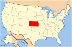
Location of Franklin County in Kansas
This is a list of the National Register of Historic Places listings in Franklin County, Kansas.
This is intended to be a complete list of the properties and districts on the National Register of Historic Places in Franklin County, Kansas, United States. The locations of National Register properties and districts for which the latitude and longitude coordinates are included below, may be seen in a map.[1]
There are 18 properties and districts listed on the National Register in the county.
- This National Park Service list is complete through NPS recent listings posted December 2, 2016.[2]
Current listings
| [3] | Name on the Register[4] | Image | Date listed[5] | Location | City or town | Description |
|---|---|---|---|---|---|---|
| 1 | Dietrich Cabin |  |
(#72000500) |
Ottawa City Park 38°36′39″N 95°16′03″W / 38.610833°N 95.2675°W |
Ottawa | In 1857 a German immigrant settled three miles south and two and one-fourth miles west of the present town of Princeton; in 1859, he built this cabin on a hill overlooking the Humboldt trail to replace the original cabin which was destroyed in a prairie fire. |
| 2 | Downtown Ottawa Historic District | 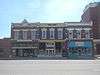 |
(#72000501) |
East side of S. Main St. from No. 135 to 3rd St. 38°36′54″N 95°16′05″W / 38.615°N 95.268056°W |
Ottawa | |
| 3 | Eight Mile Creek Warren Truss Bridge |  |
(#03000374) |
Osborne Terrace, 0.2 miles west of intersection with Eisenhower Terrace, 1.0 mile west of Main St. 38°37′52″N 95°17′08″W / 38.631111°N 95.285556°W |
Ottawa | |
| 4 | Franklin County Courthouse | 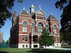 |
(#72000502) |
Main St. 38°36′48″N 95°16′03″W / 38.613333°N 95.2675°W |
Ottawa | |
| 5 | Judge James Hanway House | Upload image | (#08001173) |
658 Virginia Rd. 38°25′52″N 95°05′03″W / 38.431111°N 95.084167°W |
Lane | |
| 6 | Historic Ottawa Central Business District | Upload image | (#06000622) |
Roughly bounded by Marias des Cygnes River, S. 5th St., Walnut St., and Hickory St. 38°36′54″N 95°16′07″W / 38.615117°N 95.26861°W |
Ottawa | |
| 7 | Tauy Jones Hall | .JPG) |
(#82002659) |
Ottawa University campus, 10th and Cedar Sts. 38°36′14″N 95°15′47″W / 38.603889°N 95.263056°W |
Ottawa | |
| 8 | Tauy Jones House | .JPG) |
(#72000503) |
3 miles northeast of Ottawa on Tauy Creek 38°39′51″N 95°13′14″W / 38.664167°N 95.220556°W |
Ottawa | |
| 9 | Middle Creek Tributary Bridge | Upload image | (#85001428) |
5.8 miles west of Princeton 38°29′32″N 95°22′33″W / 38.492222°N 95.375833°W |
Princeton | |
| 10 | Old Santa Fe Railroad Depot | .JPG) |
(#73000755) |
135 W. Tecumseh St. 38°37′14″N 95°16′09″W / 38.620556°N 95.269167°W |
Ottawa | |
| 11 | Ottawa High School and Junior High School | 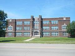 |
(#00001188) |
526 and 506 S. Main St. 38°36′37″N 95°16′07″W / 38.610278°N 95.268611°W |
Ottawa | |
| 12 | Ottawa Library | 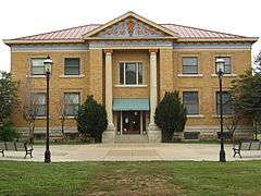 |
(#80001465) |
5th and Main Sts. 38°36′15″N 95°15′43″W / 38.604167°N 95.261944°W |
Ottawa | |
| 13 | Pleasant Valley School District #2 | Upload image | (#04000078) |
2905 Thomas Rd. 38°43′27″N 95°08′48″W / 38.724167°N 95.146667°W |
Wellsville | |
| 14 | James H. Ransom House | 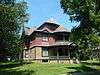 |
(#74000836) |
318 S. Locust St. 38°36′49″N 95°16′17″W / 38.613611°N 95.271389°W |
Ottawa | |
| 15 | Silkville |  |
(#72000504) |
2.5 miles southwest of Williamsburg on U.S. Route 50 38°26′25″N 95°29′13″W / 38.440278°N 95.486944°W |
Williamsburg | |
| 16 | Tauy Creek Bridge | 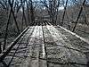 |
(#90001567) |
Over Tauy Creek, north of Interstate 35 38°39′53″N 95°13′23″W / 38.664722°N 95.223056°W |
Ottawa | |
| 17 | Walnut Creek Bridge | 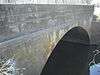 |
(#85001445) |
Off K-33, 1 mile south of Wellsville 38°41′18″N 95°05′05″W / 38.688333°N 95.084722°W |
Wellsville | |
| 18 | Wellsville Bank Building | 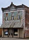 |
(#91001519) |
418 Main St. 38°43′08″N 95°04′55″W / 38.718889°N 95.081944°W |
Wellsville | The Wellsville Bank was organized on March 4, 1885 by Dr. S. F. Brooking and John Dean. They purchased Lot 9, Block 14 in September, 1884 and commenced construction on Wellsville's first brick building at 418 Main Street. |
See also
| Wikimedia Commons has media related to National Register of Historic Places in Franklin County, Kansas. |
- List of National Historic Landmarks in Kansas
- National Register of Historic Places listings in Kansas
References
- ↑ The latitude and longitude information provided in this table was derived originally from the National Register Information System, which has been found to be fairly accurate for about 99% of listings. For about 1% of NRIS original coordinates, experience has shown that one or both coordinates are typos or otherwise extremely far off; some corrections may have been made. A more subtle problem causes many locations to be off by up to 150 yards, depending on location in the country: most NRIS coordinates were derived from tracing out latitude and longitudes off of USGS topographical quadrant maps created under the North American Datum of 1927, which differs from the current, highly accurate WGS84 GPS system used by most on-line maps. Chicago is about right, but NRIS longitudes in Washington are higher by about 4.5 seconds, and are lower by about 2.0 seconds in Maine. Latitudes differ by about 1.0 second in Florida. Some locations in this table may have been corrected to current GPS standards.
- ↑ "National Register of Historic Places: Weekly List Actions". National Park Service, United States Department of the Interior. Retrieved on December 2, 2016.
- ↑ Numbers represent an ordering by significant words. Various colorings, defined here, differentiate National Historic Landmarks and historic districts from other NRHP buildings, structures, sites or objects.
- ↑ National Park Service (2009-03-13). "National Register Information System". National Register of Historic Places. National Park Service.
- ↑ The eight-digit number below each date is the number assigned to each location in the National Register Information System database, which can be viewed by clicking the number.

Municipalities and communities of Franklin County, Kansas, United States | ||
|---|---|---|
| Cities | | |
| Unincorporated communities | ||
| Ghost towns | ||
| Townships | ||
This article is issued from Wikipedia - version of the 9/26/2016. The text is available under the Creative Commons Attribution/Share Alike but additional terms may apply for the media files.