National Register of Historic Places listings in Lyon County, Kansas
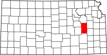
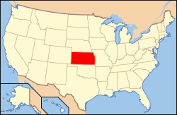
Location of Lyon County in Kansas
This is a list of the National Register of Historic Places listings in Lyon County, Kansas.
This is intended to be a complete list of the properties on the National Register of Historic Places in Lyon County, Kansas, United States. The locations of National Register properties for which the latitude and longitude coordinates are included below, may be seen in a map.[1]
There are 17 properties listed on the National Register in the county.
- This National Park Service list is complete through NPS recent listings posted December 2, 2016.[2]
Current listings
| [3] |
Name on the Register[4] |
Image |
Date listed[5] |
Location |
City or town |
Description |
|---|
| 1 |
Anderson Carnegie Memorial Library |
Upload image |
000000001987-06-25-0000June 25, 1987
(#87000958) |
The Way College of Emporia, 1300 W. 12th Ave.
38°24′46″N 96°11′38″W / 38.412778°N 96.193889°W / 38.412778; -96.193889 (Anderson Carnegie Memorial Library) |
Emporia |
|
| 2 |
Col. H.C. and Susan Cross House |
Upload image |
000000002011-08-04-0000August 4, 2011
(#11000505) |
526 Union St.
38°24′17″N 96°10′34″W / 38.404722°N 96.176111°W / 38.404722; -96.176111 (Col. H.C. and Susan Cross House) |
Emporia |
|
| 3 |
Emporia Downtown Historic District |
Upload image |
000000002012-05-01-0000May 1, 2012
(#12000249) |
Generally bounded by 10th & 3rd Aves., Mechanic & Merchant Sts.
38°24′20″N 96°10′49″W / 38.405665°N 96.180156°W / 38.405665; -96.180156 (Emporia Downtown Historic District) |
Emporia |
|
| 4 |
Warren Wesley Finney House |
Upload image |
000000001992-05-07-0000May 7, 1992
(#92000470) |
927 State St.
38°24′35″N 96°11′07″W / 38.409722°N 96.185278°W / 38.409722; -96.185278 (Warren Wesley Finney House) |
Emporia |
|
| 5 |
Granada Theater |
Upload image |
000000001985-04-04-0000April 4, 1985
(#85000693) |
809 Commercial
38°24′28″N 96°10′48″W / 38.407778°N 96.18°W / 38.407778; -96.18 (Granada Theater) |
Emporia |
|
| 6 |
Harris Bridge |
Upload image |
000000001985-07-02-0000July 2, 1985
(#85001434) |
3 miles (4.8 km) north and 4 miles (6.4 km) west of Americus
38°33′01″N 96°20′06″W / 38.550278°N 96.335°W / 38.550278; -96.335 (Harris Bridge) |
Americus |
|
| 7 |
Harris-Borman House |
Upload image |
000000001992-04-28-0000April 28, 1992
(#92000431) |
827 Mechanic
38°24′31″N 96°10′25″W / 38.408611°N 96.173611°W / 38.408611; -96.173611 (Harris-Borman House) |
Emporia |
|
| 8 |
Hartford Collegiate Institute |
Upload image |
000000001972-02-23-0000February 23, 1972
(#72000512) |
Southwestern corner of College and Plumb Aves.
38°18′32″N 95°57′25″W / 38.308889°N 95.956944°W / 38.308889; -95.956944 (Hartford Collegiate Institute) |
Hartford |
|
| 9 |
Richard Howe House |
Upload image |
000000001986-07-17-0000July 17, 1986
(#86001701) |
315 E. Logan Ave.
38°23′29″N 96°10′28″W / 38.391389°N 96.174444°W / 38.391389; -96.174444 (Richard Howe House) |
Emporia |
|
| 10 |
Keebler-Stone House |
Upload image |
000000001992-04-28-0000April 28, 1992
(#92000387) |
831 Constitution St.
38°24′27″N 96°10′57″W / 38.4075°N 96.1825°W / 38.4075; -96.1825 (Keebler-Stone House) |
Emporia |
|
| 11 |
Kress Building |
Upload image |
000000001983-08-25-0000August 25, 1983
(#83000431) |
702 Commercial St.
38°24′28″N 96°14′12″W / 38.407778°N 96.236667°W / 38.407778; -96.236667 (Kress Building) |
Emporia |
|
| 12 |
Walt Mason House |
Upload image |
000000001992-04-30-0000April 30, 1992
(#92000446) |
606 W. 12th Ave.
38°24′45″N 96°11′20″W / 38.4125°N 96.188889°W / 38.4125; -96.188889 (Walt Mason House) |
Emporia |
|
| 13 |
Old Emporia Public Library |
Upload image |
000000001981-11-02-0000November 2, 1981
(#81000279) |
118 E. 6th St.
38°24′19″N 96°10′40″W / 38.405278°N 96.177778°W / 38.405278; -96.177778 (Old Emporia Public Library) |
Emporia |
|
| 14 |
Mrs. Preston B. Plumb House |
Upload image |
000000001984-10-04-0000October 4, 1984
(#84000011) |
224 E. 6th Ave.
38°24′18″N 96°09′54″W / 38.405°N 96.165°W / 38.405; -96.165 (Mrs. Preston B. Plumb House) |
Emporia |
|
| 15 |
Soden's Grove Bridge |
|
000000001983-03-10-0000March 10, 1983
(#83000432) |
K-57/K-99
38°23′09″N 96°10′54″W / 38.385833°N 96.181667°W / 38.385833; -96.181667 (Soden's Grove Bridge) |
Emporia |
|
| 16 |
Hallie B. Soden House |
Upload image |
000000001977-11-09-0000November 9, 1977
(#77000589) |
802 S. Commercial St.
38°23′17″N 96°10′45″W / 38.388056°N 96.179167°W / 38.388056; -96.179167 (Hallie B. Soden House) |
Emporia |
|
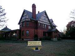
| 17 |
William Allen White House |
|
000000001971-05-14-0000May 14, 1971
(#71000318) |
927 Exchange St.
38°24′34″N 96°10′30″W / 38.409444°N 96.175°W / 38.409444; -96.175 (William Allen White House) |
Emporia |
|
See also
References
- ↑ The latitude and longitude information provided in this table was derived originally from the National Register Information System, which has been found to be fairly accurate for about 99% of listings. For about 1% of NRIS original coordinates, experience has shown that one or both coordinates are typos or otherwise extremely far off; some corrections may have been made. A more subtle problem causes many locations to be off by up to 150 yards, depending on location in the country: most NRIS coordinates were derived from tracing out latitude and longitudes off of USGS topographical quadrant maps created under the North American Datum of 1927, which differs from the current, highly accurate WGS84 GPS system used by most on-line maps. Chicago is about right, but NRIS longitudes in Washington are higher by about 4.5 seconds, and are lower by about 2.0 seconds in Maine. Latitudes differ by about 1.0 second in Florida. Some locations in this table may have been corrected to current GPS standards.
- ↑ "National Register of Historic Places: Weekly List Actions". National Park Service, United States Department of the Interior. Retrieved on December 2, 2016.
- ↑ Numbers represent an ordering by significant words. Various colorings, defined here, differentiate National Historic Landmarks and historic districts from other NRHP buildings, structures, sites or objects.
- ↑ National Park Service (2009-03-13). "National Register Information System". National Register of Historic Places. National Park Service.
- ↑ The eight-digit number below each date is the number assigned to each location in the National Register Information System database, which can be viewed by clicking the number.