| [3] |
Name on the Register[4] |
Image |
Date listed[5] |
Location |
City or town |
Description |
|---|
| 1 |
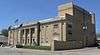
Atchison Santa Fe Freight Depot |
|
000000002001-10-11-0000October 11, 2001
(#01001090) |
200 S. Tenth St.
39°33′36″N 95°07′37″W / 39.560037°N 95.126834°W / 39.560037; -95.126834 (Atchison Santa Fe Freight Depot) |
Atchison |
Today the Santa-Fe Depot Rail Museum
|
| 2 |
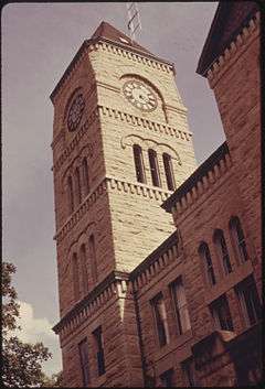
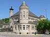
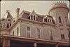
Atchison County Courthouse |
|
000000001975-04-16-0000April 16, 1975
(#75000704) |
Southwestern corner of 5th and Parallel Sts.
39°33′58″N 95°07′10″W / 39.566111°N 95.119444°W / 39.566111; -95.119444 (Atchison County Courthouse) |
Atchison |
|
| 3 |
Atchison County Memorial Hall |
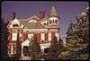
|
000000002007-04-18-0000April 18, 2007
(#07000317) |
819 Commercial St.
39°33′44″N 95°07′27″W / 39.562222°N 95.124167°W / 39.562222; -95.124167 (Atchison County Memorial Hall) |
Atchison |
|
| 4 |
Atchison Post Office |
|
000000001972-03-16-0000March 16, 1972
(#72000484) |
621 Kansas Ave.[6]
39°33′48″N 95°07′18″W / 39.563208°N 95.121569°W / 39.563208; -95.121569 (Atchison Post Office) |
Atchison |
|
| 5 |
Francis and Harriet Baker House |
|
000000002003-08-28-0000August 28, 2003
(#03000838) |
823 N. 5th St.
39°34′13″N 95°07′10″W / 39.570312°N 95.119487°W / 39.570312; -95.119487 (Francis and Harriet Baker House) |
Atchison |
|
| 6 |
Benedictine College North Campus Historic Complex |
|
000000001982-03-17-0000March 17, 1982
(#82002651) |
2nd and Division Sts.
39°34′21″N 95°06′52″W / 39.5725°N 95.114444°W / 39.5725; -95.114444 (Benedictine College North Campus Historic Complex) |
Atchison |
|
| 7 |
George T. and Minnie Searles Bolman House |
|
000000002006-05-17-0000May 17, 2006
(#06000385) |
418 N. 4th St.
39°33′57″N 95°07′03″W / 39.565907°N 95.117470°W / 39.565907; -95.117470 (George T. and Minnie Searles Bolman House) |
Atchison |
|
| 8 |
Henry Braun House |
|
000000002006-05-17-0000May 17, 2006
(#06000387) |
1307 Division St.
39°34′20″N 95°07′51″W / 39.572221°N 95.130910°W / 39.572221; -95.130910 (Henry Braun House) |
Atchison |
|
| 9 |
J. P. Brown House |
|
000000001975-04-14-0000April 14, 1975
(#75000705) |
805 N. 4th St.
39°34′10″N 95°07′05″W / 39.569444°N 95.118056°W / 39.569444; -95.118056 (J. P. Brown House) |
Atchison |
|
| 10 |
Burnes Rental Houses Historic District |
|
000000002005-12-06-0000December 6, 2005
(#05001361) |
615, 617, and 621 N. 3rd St.
39°34′05″N 95°06′59″W / 39.568054°N 95.116456°W / 39.568054; -95.116456 (Burnes Rental Houses Historic District) |
Atchison |
|
| 11 |
Campbell Chapel AME Church |
|
000000002003-01-17-0000January 17, 2003
(#02001701) |
715 Atchison St.
39°33′55″N 95°07′21″W / 39.565365°N 95.122376°W / 39.565365; -95.122376 (Campbell Chapel AME Church) |
Atchison |
|
| 12 |
John Drimmel, Sr. Farm |
Upload image |
000000002004-05-20-0000May 20, 2004
(#04000452) |
16339 290th Rd.
39°34′24″N 95°11′03″W / 39.573333°N 95.184167°W / 39.573333; -95.184167 (John Drimmel, Sr. Farm) |
Atchison |
|
| 13 |
Amelia Earhart Birthplace |
|
000000001971-04-16-0000April 16, 1971
(#71000302) |
223 N. Terrace
39°33′50″N 95°06′52″W / 39.563758°N 95.114486°W / 39.563758; -95.114486 (Amelia Earhart Birthplace) |
Atchison |
|
| 14 |
Amelia Earhart Historic District |
|
000000002002-02-01-0000February 1, 2002
(#01001543) |
115-125, 200-227, 302-315, 318, 324 2nd St., 203-305 North Terrace, 124, 200, 300 3rd St., and 205, 112, and 224 Santa Fe St.
39°34′05″N 95°06′53″W / 39.568056°N 95.114722°W / 39.568056; -95.114722 (Amelia Earhart Historic District) |
Atchison |
|
| 15 |
Ebenezer Baptist Church |
Upload image |
000000002005-11-30-0000November 30, 2005
(#05001343) |
826 Riley
39°34′09″N 95°07′28″W / 39.569167°N 95.124444°W / 39.569167; -95.124444 (Ebenezer Baptist Church) |
Atchison |
|
| 16 |
James M. Edmiston House |
Upload image |
000000002006-05-17-0000May 17, 2006
(#06000386) |
311 S. 7th St.
39°33′33″N 95°07′18″W / 39.559167°N 95.121667°W / 39.559167; -95.121667 (James M. Edmiston House) |
Atchison |
|
| 17 |
Glancy/Pennell House |
|
000000001983-08-26-0000August 26, 1983
(#83000416) |
519 N. 5th St.
39°34′02″N 95°07′10″W / 39.567097°N 95.119407°W / 39.567097; -95.119407 (Glancy/Pennell House) |
Atchison |
|
| 18 |
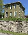
Glick-Orr House |
|
000000001992-02-26-0000February 26, 1992
(#92000060) |
503 N. Second St.
39°33′59″N 95°06′56″W / 39.566428°N 95.115516°W / 39.566428; -95.115516 (Glick-Orr House) |
Atchison |
|
| 19 |
A. J. Harwi House |
|
000000001975-05-06-0000May 6, 1975
(#75000706) |
1103 Atchison St.
39°33′56″N 95°07′47″W / 39.565535°N 95.129717°W / 39.565535; -95.129717 (A. J. Harwi House) |
Atchison |
|
| 20 |
Hausner House |
|
000000002005-12-06-0000December 6, 2005
(#05001358) |
400 N. 3rd St.
39°33′55″N 95°06′57″W / 39.565372°N 95.115941°W / 39.565372; -95.115941 (Hausner House) |
Atchison |
|
| 21 |
W. W. Hetherington House |
|
000000001974-07-12-0000July 12, 1974
(#74000818) |
805 N. 5th St.
39°33′49″N 95°07′08″W / 39.563611°N 95.118889°W / 39.563611; -95.118889 (W. W. Hetherington House) |
Atchison |
|
| 22 |
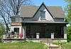
Michael J. and Mattie Horan House |
|
000000002006-05-17-0000May 17, 2006
(#06000384) |
822 N. 4th St.
39°34′13″N 95°07′02″W / 39.570278°N 95.117222°W / 39.570278; -95.117222 (Michael J. and Mattie Horan House) |
Atchison |
|
| 23 |
Frank Howard House |
|
000000001984-10-15-0000October 15, 1984
(#84000141) |
305 N. Terrace
39°33′51″N 95°06′52″W / 39.564167°N 95.114444°W / 39.564167; -95.114444 (Frank Howard House) |
Atchison |
|
| 24 |
Edgar W. Howe House |
|
000000001972-03-16-0000March 16, 1972
(#72000485) |
1117 N. 3rd St.
39°34′28″N 95°07′01″W / 39.574444°N 95.116944°W / 39.574444; -95.116944 (Edgar W. Howe House) |
Atchison |
|
| 25 |
Jansen House |
|
000000002005-12-06-0000December 6, 2005
(#05001360) |
806 N. 3rd St.
39°34′12″N 95°06′58″W / 39.569876°N 95.115973°W / 39.569876; -95.115973 (Jansen House) |
Atchison |
|
| 26 |
Lanphear-Mitchell House |
|
000000002005-12-06-0000December 6, 2005
(#05001359) |
417 N. 4th St.
39°33′57″N 95°07′05″W / 39.565823°N 95.117971°W / 39.565823; -95.117971 (Lanphear-Mitchell House) |
Atchison |
|
| 27 |
Lincoln School |
Upload image |
000000002006-06-07-0000June 7, 2006
(#06000469) |
801 Division St.
39°34′18″N 95°07′25″W / 39.571667°N 95.123611°W / 39.571667; -95.123611 (Lincoln School) |
Atchison |
|
| 28 |
John A. Martin Grade School |
Upload image |
000000002016-06-23-0000June 23, 2016
(#16000403) |
507 Division St.
39°34′19″N 95°07′12″W / 39.571957°N 95.120023°W / 39.571957; -95.120023 (John A. Martin Grade School) |
Atchison |
|
| 29 |
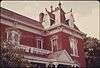
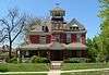
McInteer Villa |
|
000000001975-03-26-0000March 26, 1975
(#75000707) |
1301 Kansas Ave.
39°33′48″N 95°08′01″W / 39.563337°N 95.133511°W / 39.563337; -95.133511 (McInteer Villa) |
Atchison |
|
| 30 |
Mount St. Scholastica Convent |
Upload image |
000000001972-04-13-0000April 13, 1972
(#72000486) |
801 S. 8th St.
39°32′06″N 95°07′28″W / 39.535°N 95.124444°W / 39.535; -95.124444 (Mount St. Scholastica Convent) |
Atchison |
|
| 31 |
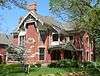
H. E. Muchnic House |
|
000000001974-07-12-0000July 12, 1974
(#74000819) |
704 N. 4th St.
39°34′07″N 95°07′02″W / 39.568611°N 95.117222°W / 39.568611; -95.117222 (H. E. Muchnic House) |
Atchison |
|
| 32 |
Robert L. Pease House |
|
000000001983-08-26-0000August 26, 1983
(#83000417) |
203 N. 2nd St.
39°33′47″N 95°06′56″W / 39.563103°N 95.115549°W / 39.563103; -95.115549 (Robert L. Pease House) |
Atchison |
|
| 33 |
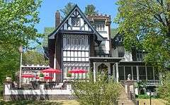
Price Villa |
Upload image |
000000001972-03-16-0000March 16, 1972
(#72000487) |
801 S. 8th St.
39°33′13″N 95°07′30″W / 39.553611°N 95.125°W / 39.553611; -95.125 (Price Villa) |
Atchison |
|
| 34 |
Ronald and Dorcas Ramsay House |
Upload image |
000000002006-06-07-0000June 7, 2006
(#06000470) |
1415 Riverview Dr.
39°32′44″N 95°06′51″W / 39.545556°N 95.114167°W / 39.545556; -95.114167 (Ronald and Dorcas Ramsay House) |
Atchison |
|
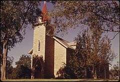
| 35 |
St. Patrick's Catholic Church |
|
000000001998-11-25-0000November 25, 1998
(#98001358) |
234th Rd., 2 miles west of U.S. Route 73
39°28′10″N 95°07′17″W / 39.469444°N 95.121389°W / 39.469444; -95.121389 (St. Patrick's Catholic Church) |
Atchison |
|
| 36 |
Schmitt House |
|
000000002005-11-30-0000November 30, 2005
(#05001342) |
1110 W. Division St.
39°34′18″N 95°07′51″W / 39.571667°N 95.130833°W / 39.571667; -95.130833 (Schmitt House) |
Atchison |
|
| 37 |
Frederick W. Stein House |
|
000000002004-01-14-0000January 14, 2004
(#03001391) |
324 Santa Fe
39°33′50″N 95°07′03″W / 39.563797°N 95.117456°W / 39.563797; -95.117456 (Frederick W. Stein House) |
Atchison |
|
| 38 |
Stranger Creek Warren Truss Bridge |
|
000000002004-10-12-0000October 12, 2004
(#04001139) |
On Haskell Rd., 0.8 miles south of the junction with 262 Rd., 0.5 miles south of Farmington
39°30′41″N 95°18′36″W / 39.511389°N 95.31°W / 39.511389; -95.31 (Stranger Creek Warren Truss Bridge) |
Farmington |
|
| 39 |
Trinity Episcopal Church |
|
000000001985-04-04-0000April 4, 1985
(#85000692) |
300 S. 5th St.
39°33′33″N 95°07′06″W / 39.559167°N 95.118333°W / 39.559167; -95.118333 (Trinity Episcopal Church) |
Atchison |
|
| 40 |
B. P. Waggener House |
|
000000001974-05-03-0000May 3, 1974
(#74000820) |
819 N. 4th St.
39°34′13″N 95°07′04″W / 39.570278°N 95.117778°W / 39.570278; -95.117778 (B. P. Waggener House) |
Atchison |
|
| 41 |
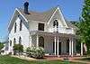
Balie P. Waggener House |
|
000000002006-05-17-0000May 17, 2006
(#06000388) |
415 W. Riley St.
39°34′11″N 95°07′06″W / 39.569699°N 95.118393°W / 39.569699; -95.118393 (Balie P. Waggener House) |
Atchison |
|
| 42 |
Wherrett-Mize Drug Company Building |
|
000000002010-07-06-0000July 6, 2010
(#10000432) |
201 Main St.
39°33′40″N 95°06′56″W / 39.561039°N 95.115632°W / 39.561039; -95.115632 (Wherrett-Mize Drug Company Building) |
Atchison |
|
_from_SE_1.JPG)
.jpg)
_from_W_1.JPG)
_from_SE_2.JPG)
_from_S_1.JPG)
_from_SSE_1.JPG)
_from_S_2.JPG)
_from_WNW_1.JPG)
_from_ESE_1.JPG)
_from_W_1.JPG)
_from_E_2_long.JPG)
_from_S_1.JPG)
_from_SSE_1.JPG)
_from_NW_1.JPG)
_from_WNW_1_long.JPG)