National Register of Historic Places listings in Anderson County, Tennessee
Location of Anderson County in Tennessee
This is a list of the National Register of Historic Places listings in Anderson County, Tennessee.
This is intended to be a complete list of the properties and districts on the National Register of Historic Places in Anderson County, Tennessee, United States. Latitude and longitude coordinates are provided for many National Register properties and districts; these locations may be seen together in a map.[1]
There are 20 properties and districts in the county that are listed on the National Register.
See also National Register of Historic Places listings in Roane County, Tennessee for additional properties in Oak Ridge and Oliver Springs, cities that span the county line.
| Anderson – Bedford – Benton – Bledsoe – Blount – Bradley – Campbell – Cannon – Carroll – Carter – Cheatham – Chester – Claiborne – Clay – Cocke – Coffee – Crockett – Cumberland – Davidson – Decatur – DeKalb – Dickson – Dyer – Fayette – Fentress – Franklin – Gibson – Giles – Grainger – Greene – Grundy – Hamblen – Hamilton – Hancock – Hardeman – Hardin – Hawkins – Haywood – Henderson – Henry – Hickman – Houston – Humphreys – Jackson – Jefferson – Johnson – Knox – Lake – Lauderdale – Lawrence – Lewis – Lincoln – Loudon – Macon – Madison – Marion – Marshall – Maury – McMinn – McNairy – Meigs – Monroe – Montgomery – Moore – Morgan – Obion – Overton – Perry – Pickett – Polk – Putnam – Rhea – Roane – Robertson – Rutherford – Scott – Sequatchie – Sevier – Shelby – Smith – Stewart – Sullivan – Sumner – Tipton – Trousdale – Unicoi – Union – Van Buren – Warren – Washington – Wayne – Weakley – White – Williamson – Wilson |
- This National Park Service list is complete through NPS recent listings posted December 2, 2016.[2]
Current listings
| [3] | Name on the Register[4] | Image | Date listed[5] | Location | City or town | Description |
|---|---|---|---|---|---|---|
| 1 | Arnwine Cabin |  |
(#76001760) |
State Route 61 36°10′53″N 84°04′10″W / 36.181389°N 84.069444°W |
Norris | Part of the collection of the Museum of Appalachia |
| 2 | Bear Creek Road Checking Station | 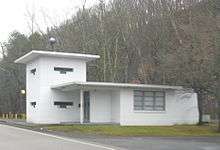 |
(#92000411) |
Junction of S. Illinois Ave. and Bear Creek Rd. 35°59′57″N 84°14′35″W / 35.999167°N 84.243056°W |
Oak Ridge | |
| 3 | Bethel Valley Road Checking Station | 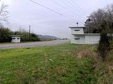 |
(#92000410) |
Junction of Bethel Valley and Scarboro Rds. 35°59′13″N 84°13′02″W / 35.986944°N 84.217222°W |
Oak Ridge | |
| 4 | Luther Brannon House |  |
(#91001108) |
151 Oak Ridge Turnpike 36°02′40″N 84°12′34″W / 36.044444°N 84.209444°W |
Oak Ridge | |
| 5 | Briceville Community Church and Cemetery |  |
(#03000697) |
State Route 116 36°10′43″N 84°10′59″W / 36.178611°N 84.183056°W |
Briceville | Rural Gothic Revival church, now primarily a community center |
| 6 | Cross Mountain Miners' Circle |  |
(#06000134) |
Circle Cemetery Ln. 36°10′26″N 84°11′11″W / 36.173889°N 84.186389°W |
Briceville | |
| 7 | Daugherty Furniture Building |  |
(#10000936) |
307 N. Main St. 36°06′09″N 84°07′55″W / 36.1025°N 84.131944°W |
Clinton | |
| 8 | Edwards-Fowler House | Upload image | (#75001726) |
3½ miles south of Rocky Top on Dutch Valley Rd. 36°10′18″N 84°10′03″W / 36.171667°N 84.1675°W |
Rocky Top | |
| 9 | Fort Anderson on Militia Hill |  |
(#11000830) |
Vowell Mountain Rd. 36°12′56″N 84°10′32″W / 36.215633°N 84.175481°W |
Rocky Top | Site of the Tennessee state militia's garrison during the Coal Creek War of 1891 and 1892, when local coal miners and the state government battled over the use of convict labor in area coal mines. |
| 10 | Fraterville Miners' Circle Cemetery |  |
(#04001459) |
Leach Cemetery Lane 36°12′39″N 84°08′25″W / 36.210833°N 84.140278°W |
Rocky Top | |
| 11 | Freels Cabin | Upload image | (#92000407) |
Freels Bend Rd. 35°57′48″N 84°13′25″W / 35.963333°N 84.223611°W |
Oak Ridge | Also called "Freels Bend Cabin"; built in 1844, currently located on restricted federal property |
| 12 | J. B. Jones House |  |
(#19910905) |
Old Edgemoor Road between Bethel Valley Road and Melton Hill Lake 36°00′33″N 84°10′09″W / 36.009167°N 84.169167°W |
Oak Ridge | |
| 13 | Green McAdoo School | 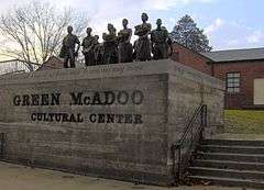 |
(#05001218) |
101 School St. 36°06′16″N 84°08′24″W / 36.104444°N 84.14°W |
Clinton | |
| 14 | Norris Dam State Park Rustic Cabins Historic District |  |
(#14000446) |
125 Village Green Circle 36°13′32″N 84°05′10″W / 36.2256°N 84.0860°W |
Rocky Top | |
| 15 | Norris District |  |
(#75001727) |
City of Norris on U.S. Route 441 36°11′47″N 84°04′08″W / 36.196389°N 84.068889°W |
Norris | |
| 16 | Norris Hydroelectric Project | .jpg) |
(#16000165) |
300 Powerhouse Way 36°13′27″N 84°05′32″W / 36.224167°N 84.092222°W |
Norris | Extends into Campbell County |
| 17 | Oak Ridge Historic District | 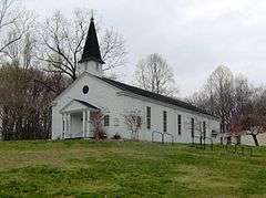 |
(#91001109) |
Roughly bounded by East Drive, West Outer Drive, Louisiana Avenue, and Tennessee Avenue 36°01′41″N 84°15′10″W / 36.028056°N 84.252778°W |
Oak Ridge | Contributing properties in the historic district include United Church, The Chapel on the Hill, the Alexander Inn, and the elementary school now occupied by the Children's Museum of Oak Ridge. |
| 18 | Oliver Springs Banking Company |  |
(#92000357) |
110 E. Tri County Boulevard 36°02′43″N 84°20′23″W / 36.045278°N 84.339722°W |
Oliver Springs | |
| 19 | Ritz Theatre and Hoskins Rexall Drug Store No. 2 | 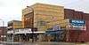 |
(#98001446) |
111-121 N. Main St. 36°06′00″N 84°07′59″W / 36.1°N 84.133056°W |
Clinton | Hoskins Drug Store is a family-owned business that was established on Market Street in Clinton in 1930 by R.C. "Dudley" Hoskins. The Main Street location, which is part of the National Register listing, opened in 1947. At one time there were as many as 13 Hoskins stores in East Tennessee.[6] |
| 20 | Woodland-Scarboro Historic District |  |
(#91001106) |
Roughly bounded by Rutgers Avenue, Lafayette Drive, Benedict Avenue, Wilberforce Avenue, and Illinois Avenue 36°00′16″N 84°15′06″W / 36.004444°N 84.251667°W |
Oak Ridge |
See also
| Wikimedia Commons has media related to National Register of Historic Places in Anderson County, Tennessee. |
- List of National Historic Landmarks in Tennessee
- National Register of Historic Places listings in Tennessee
References
- ↑ The latitude and longitude information provided in this table was derived originally from the National Register Information System, which has been found to be fairly accurate for about 99% of listings. For about 1% of NRIS original coordinates, experience has shown that one or both coordinates are typos or otherwise extremely far off; some corrections may have been made. A more subtle problem causes many locations to be off by up to 150 yards, depending on location in the country: most NRIS coordinates were derived from tracing out latitude and longitudes off of USGS topographical quadrant maps created under the North American Datum of 1927, which differs from the current, highly accurate WGS84 GPS system used by most on-line maps. Chicago is about right, but NRIS longitudes in Washington are higher by about 4.5 seconds, and are lower by about 2.0 seconds in Maine. Latitudes differ by about 1.0 second in Florida. Some locations in this table may have been corrected to current GPS standards.
- ↑ "National Register of Historic Places: Weekly List Actions". National Park Service, United States Department of the Interior. Retrieved on December 2, 2016.
- ↑ Numbers represent an ordering by significant words. Various colorings, defined here, differentiate National Historic Landmarks and historic districts from other NRHP buildings, structures, sites or objects.
- ↑ National Park Service (2008-04-24). "National Register Information System". National Register of Historic Places. National Park Service.
- ↑ The eight-digit number below each date is the number assigned to each location in the National Register Information System database, which can be viewed by clicking the number.
- ↑ Clayton Hensley, Hoskins stores celebrate 80th anniversary; Pharmacy carries everything from gifts to soda fountain, Knoxville News Sentinel, April 29, 2010
| Topics | |
|---|---|
| Lists by states |
|
| Lists by insular areas | |
| Lists by associated states | |
| Other areas | |
| |
Municipalities and communities of Anderson County, Tennessee, United States | ||
|---|---|---|
| Cities | ||
| Town | ||
| CDP | ||
| Other unincorporated communities | ||
| Ghost towns/ neighborhoods | ||
| Footnotes | ‡This populated place also has portions in an adjacent county or counties | |
This article is issued from Wikipedia - version of the 5/13/2016. The text is available under the Creative Commons Attribution/Share Alike but additional terms may apply for the media files.