Clinton, Tennessee
| Clinton, Tennessee | |
|---|---|
| City | |
|
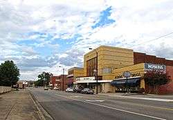
Main Street | |
 Location in Anderson County and state of Tennessee. | |
| Coordinates: 36°6′17″N 84°7′43″W / 36.10472°N 84.12861°W | |
| Country | United States |
| State | Tennessee |
| County | Anderson |
| Incorporated | 1801[1] |
| Government | |
| • Mayor | Scott Burton |
| Area | |
| • Total | 12.0 sq mi (31.1 km2) |
| • Land | 11.4 sq mi (29.6 km2) |
| • Water | 0.6 sq mi (1.5 km2) |
| Elevation | 820 ft (250 m) |
| Population (2010) | |
| • Total | 9,841 |
| • Density | 861/sq mi (332.4/km2) |
| Time zone | Eastern (EST) (UTC-5) |
| • Summer (DST) | EDT (UTC-4) |
| ZIP codes | 37716-37717 |
| Area code(s) | 865 |
| FIPS code | 47-15580[2] |
| GNIS feature ID | 1305981[3] |
| Website |
www |
Clinton is a city in Anderson County, Tennessee, United States. Its population was 9,841 at the 2010 census.[4] It is the county seat of Anderson County.[5] Clinton is included in the Knoxville, Tennessee Metropolitan Statistical Area.
History
Prehistoric Native American habitation was not uncommon throughout the Clinch valley, especially during the Woodland period (1000 B.C. – 1000 A.D.) and the Mississippian period (1000–1550 A.D.). A number of such habitation sites were excavated in the 1930s and 1950s in anticipation of the construction of Norris Dam and Melton Hill Dam, respectively. The Melton Hill excavations uncovered two substantial Woodland period villages along the Clinch at Bull Bluff and Freels Bend, both approximately 20 miles (32 km) downstream from Clinton.[6]
By the time Euro-American explorers and long hunters arrived in the Clinch valley in the mid-18th century, what is now Anderson County was part of a vast stretch of land claimed by the Cherokee.[7] Although the Treaty of Holston, signed in 1791, was intended as a negotiation with the Cherokee to prohibit Euro-American settlement of the area including what is today Anderson County, the treaty became ineffective as more settlers moved through the Appalachian Mountains from Virginia and North Carolina into Tennessee. The earliest settlers in Anderson County included the Wallace, Gibbs, Freels, Frost and Tunnell families. The flooding of white settlers into the Indian domain was cause for several skirmishes, which eased after the Treaty of Tellico in 1798 (including an origination point for the land to be relinquished from the Cherokee being the Tellico Blockhouse) allowed for greater ease in settling the area.[8]
Founded in 1801, the town of Burrville was named in honor of Aaron Burr, first-term Vice President under Thomas Jefferson. Land was selected and partitioned for a courthouse, and Burrville was designated as the county seat for the newly formed Anderson County. The county was partitioned from portions of Grainger County and Knox County in 1801; neighboring Roane County was also formed from a portion of Knox County in 1801, making Anderson and Roane counties effectively "sister counties".[9]
On November 8, 1809, by act of Tennessee State Legislature, the town of Burrville was renamed because of the disgrace felt when Burr was charged with treason for conspiring with the Governor of the Louisiana Purchase, to form another country from part of the Louisiana Purchase and part of Mexico. The selection of the name "Clinton" was most likely to honor George Clinton or his nephew, DeWitt Clinton.[10] George Clinton was one of Burr's New York political rivals who, along with Alexander Hamilton, destroyed Burr's bid for the governorship of the state of New York after his single-term Vice Presidency. George Clinton succeeded Burr as the second-term Vice President for Thomas Jefferson in 1805 (and also served as James Madison's Vice President, making Clinton the first Vice President to serve under two presidents and the first Vice President to die in office). Because of the political position of George Clinton as Vice President at the time of Burrville's name change, compared to DeWitt Clinton's position as the mayor of New York City, most likely the residents of the town of Burrville would have been more readily identifiable and more honorable toward George Clinton than DeWitt; therefore, it is most likely Clinton was named after George Clinton, barring historical proof.
Clinton High School desegregation controversy

In 1956, Clinton gained national attention when segregationists opposed the desegregation of Clinton High School. Following the U.S. Supreme Court decision in the case of Brown v. Board of Education, a court order required the desegregation of the high school. Twelve African-American students enrolled in the high school in the fall of 1956. On August 27, 1956, the Clinton Twelve attended classes at Clinton High School for the first time, becoming the first African-Americans to desegregate a state-supported public school in the Southeast. While the first day of classes occurred without incident, pro-segregation forces led by John Kasper and Asa Carter arrived in Clinton the following week and rallied the city's white citizens. Riots broke out in early September, forcing Governor Frank G. Clement to station National Guard units in Clinton throughout September. Sporadic violence and threats continued for the next two years, culminating in the bombing of Clinton High School on October 5, 1958. With an influx of outside aid, however, the school was quickly rebuilt.[11]
A museum dedicated to the desegregation crisis, the Green McAdoo Cultural Center, is now housed in Clinton's segregation-era Green McAdoo School.
Rogers Group quarry and asphalt plant controversy
In the 1990s, the Rogers Group, a firm specializing in road paving, began a campaign to reactivate an abandoned quarry and build an asphalt plant just east of Clinton near the community of Bethel. The initiative met with opposition from local and environmental groups, who were concerned that the plant would release cancer-causing toxins into nearby residential neighborhoods. Others were concerned about plummeting property values, noise pollution, damage from rock blasting, and environmental damage to Buffalo Creek. The company argued that it would follow stringent environmental and pollution guidelines, retention ponds would limit runoff, and that the site would be surrounded by vegetation. Nevertheless, Anderson County refused to rezone the quarry property for industrial uses, and Rogers Group sued the county in 1995.[12][13]
In December 2006, after Rogers Group's lawsuit had stagnated, the city of Clinton voted to annex the quarry property.[12] On August 20, 2007, the Clinton City Council voted 6–1 to rezone the quarry property for industrial uses, paving the way for the plant's construction. In response, a local advocacy group known as Citizens for Safety and Clean Air filed a lawsuit on behalf of several Bethel residents in Anderson County Chancery Court contending that the council's rezoning was unconstitutional and seeking an injunction preventing the council from rezoning the property as an industrial zone.[14]
Geography

Clinton is located at 36°6′17″N 84°7′43″W / 36.10472°N 84.12861°W (36.104772, −84.128487),[15] along the Clinch River, immediately downstream from a point where the southwestward-flowing river bends sharply to the northeast before wrapping around Lost Ridge and continuing again toward the southwest. This section of the river is technically part of Melton Hill Lake, a reservoir created by the impoundment of the Clinch at Melton Hill Dam some 35 miles (56 km) downstream from Clinton. Clinton is located approximately 59 miles (95 km) upstream from the mouth of the Clinch at the Tennessee River.
Clinton is surrounded by a series of long, narrow ridges that represent the western fringe of the Appalachian Ridge and Valley Province. Northwest of Clinton is Walden Ridge, the eastern escarpment of the Cumberland Plateau.
Clinton is concentrated around the junction of Tennessee State Route 61 and U.S. Route 25W. State Route 61 connects the city to Norris and Andersonville to the northeast and the community of Marlow and the town of Oliver Springs to the southwest, following a natural series of pathways through the mountain terrain. U.S. Route 25W connects the city to Knoxville to the southeast and Rocky Top and Caryville to the north. Interstate 75 intersects TN-61 northeast of downtown Clinton.
According to the United States Census Bureau, Clinton has a total area of 12.0 square miles (31.1 km2), of which 11.4 square miles (29.6 km2) is land and 0.58 square miles (1.5 km2), or 4.91%, is water.[4]
Demographics
| Historical population | |||
|---|---|---|---|
| Census | Pop. | %± | |
| 1870 | 325 | — | |
| 1880 | 263 | −19.1% | |
| 1890 | 1,198 | 355.5% | |
| 1900 | 1,111 | −7.3% | |
| 1910 | 1,090 | −1.9% | |
| 1920 | 1,409 | 29.3% | |
| 1930 | 1,927 | 36.8% | |
| 1940 | 2,761 | 43.3% | |
| 1950 | 3,712 | 34.4% | |
| 1960 | 4,943 | 33.2% | |
| 1970 | 4,794 | −3.0% | |
| 1980 | 5,245 | 9.4% | |
| 1990 | 8,972 | 71.1% | |
| 2000 | 9,409 | 4.9% | |
| 2010 | 9,841 | 4.6% | |
| Est. 2015 | 10,049 | [16] | 2.1% |
| Sources:[17][18] | |||
As of the census[2] of 2000, there were 9,409 people, 4,201 households, and 2,688 families residing in the city. The population density was 862.8 people per square mile (333.0/km²). There were 4,441 housing units at an average density of 407.2 per square mile (157.2/km²). The racial makeup of the city was 95.47% White, 2.72% African American, 0.33% Native American, 0.38% Asian, 0.28% from other races, and 0.82% from two or more races. Hispanic or Latino of any race were 0.85% of the population.
There were 4,201 households out of which 27.4% had children under the age of 18 living with them, 47.9% were married couples living together, 13.2% had a female householder with no husband present, and 36.0% were non-families. 31.8% of all households were made up of individuals and 12.7% had someone living alone who was 65 years of age or older. The average household size was 2.21 and the average family size was 2.78.
In the city the population was spread out with 21.6% under the age of 18, 8.9% from 18 to 24, 28.2% from 25 to 44, 23.7% from 45 to 64, and 17.6% who were 65 years of age or older. The median age was 39 years. For every 100 females there were 86.4 males. For every 100 females age 18 and over, there were 81.7 males.
The median income for a household in the city was $32,481, and the median income for a family was $43,099. Males had a median income of $32,120 versus $23,550 for females. The per capita income for the city was $17,730. About 11.8% of families and 16.5% of the population were below the poverty line, including 21.1% of those under age 18 and 11.1% of those age 65 or over.
Climate
The climate in this area is characterized by relatively high temperatures and evenly distributed precipitation throughout the year. According to the Köppen Climate Classification system, Clinton has a Humid subtropical climate, abbreviated "Cfa" on climate maps.[19]
| Climate data for Clinton, Tennessee | |||||||||||||
|---|---|---|---|---|---|---|---|---|---|---|---|---|---|
| Month | Jan | Feb | Mar | Apr | May | Jun | Jul | Aug | Sep | Oct | Nov | Dec | Year |
| Average high °C (°F) | 7 (45) |
10 (50) |
16 (60) |
21 (70) |
25 (77) |
29 (84) |
31 (87) |
30 (86) |
27 (80) |
21 (70) |
14 (58) |
9 (48) |
20 (68) |
| Average low °C (°F) | −4 (25) |
−2 (28) |
2 (36) |
6 (43) |
11 (52) |
16 (60) |
18 (65) |
18 (64) |
14 (58) |
7 (45) |
2 (36) |
−2 (29) |
7 (45) |
| Average precipitation mm (inches) | 130 (5.1) |
135 (5.3) |
145 (5.7) |
109 (4.3) |
97 (3.8) |
117 (4.6) |
132 (5.2) |
104 (4.1) |
81 (3.2) |
66 (2.6) |
91 (3.6) |
130 (5) |
1,339 (52.7) |
| Source: Weatherbase [20] | |||||||||||||
Notable people
- Trey Hollingsworth, congressman born in Clinton
- John C. Houk, congressman born in Clinton
- The McKameys, Southern Gospel group based in Clinton
- Charles McRae, NFL 1st round draft choice, All-American football tackle (attended University of Tennessee)
- John R. Neal, congressman born near here
- Larry Seivers, two-time All-American wide receiver at the University of Tennessee; drafted into the NFL by the Seattle Seahawks but did not play[21][22]
- William "Fiddlin' Bill" Sievers, an early country music guitarist, and several other members of the Tennessee Ramblers band were based in Clinton.[23]
References
- ↑ Tennessee Blue Book, 2005–2006, pp. 618–625.
- 1 2 "American FactFinder". United States Census Bureau. Archived from the original on 2013-09-11. Retrieved 2008-01-31.
- ↑ "US Board on Geographic Names". United States Geological Survey. 2007-10-25. Retrieved 2008-01-31.
- 1 2 "Geographic Identifiers: 2010 Demographic Profile Data (G001): Clinton city, Tennessee". U.S. Census Bureau, American Factfinder. Retrieved August 8, 2013.
- ↑ "Find a County". National Association of Counties. Archived from the original on 2011-05-31. Retrieved 2011-06-07.
- ↑ Glyn DuVall, "A Phase I Archaeological Survey of Proposed Potable Water Storage and Force Main Facilities, Y-12 National Security Complex Site, Anderson County, Tennessee." August 2005. Retrieved: 21 February 2008.
- ↑ Snyder Roberts, "Historical Background of Anderson County, TN," originally published in History of Clinton Senior High School, 1971. Retrieved: 21 February 2008.
- ↑ Overholt, James (1989). Anderson County, Tennessee. The Donning Company. pp. 13–20. ISBN 0-89865-770-9.
- ↑ Wells, Emma Middleton (1927). History of Roane County, Tennessee, Volume 1. The Lookout Publishing Company. pp. 9–11. ISBN 0-8063-8003-9.
- ↑ Tara Mitchell Mielnik, Anderson County." The Tennessee Encyclopedia of History and Culture, 2009. Retrieved: 11 February 2013.
- ↑ Carroll Van West, "Clinton Desegregation Crisis." The Tennessee Encyclopedia of History and Culture, 2009. Retrieved: 11 February 2013.
- 1 2 Leean Tupper, "Citizens Sue Clinton and Rogers Group," 19 September 2007. Retrieved: 21 February 2008.
- ↑ Bob Fowler, "Clinton Passes Annex Rezoning." 21 August 2007. Retrieved: 21 February 2008.
- ↑ Bob Fowler, "Group Files Lawsuit Over Council's Rezoning." 19 September 2007. Retrieved: 26 February 2016.
- ↑ "US Gazetteer files: 2010, 2000, and 1990". United States Census Bureau. 2011-02-12. Retrieved 2011-04-23.
- ↑ "Annual Estimates of the Resident Population for Incorporated Places: April 1, 2010 to July 1, 2015". Retrieved July 2, 2016.
- ↑ "Census of Population and Housing: Decennial Censuses". United States Census Bureau. Retrieved 2012-03-04.
- ↑ "Incorporated Places and Minor Civil Divisions Datasets: Subcounty Resident Population Estimates: April 1, 2010 to July 1, 2012". Population Estimates. U.S. Census Bureau. Archived from the original on 17 June 2013. Retrieved 11 December 2013.
- ↑ Climate Summary for Clinton, Tennessee
- ↑ "Weatherbase.com". Weatherbase. 2013. Retrieved on September 20, 2013.
- ↑ Steve Kiner Interview with Larry Seivers, October 29, 2002
- ↑ 2005 Alltel SEC Football Legends, SEC website
- ↑ Charles Wolfe, The Tennessee Ramblers: Ramblin' On." Old Time Music, Summer 1974, pp. 5–11. Retrieved: 17 December 2008.
External links
| Wikimedia Commons has media related to Clinton, Tennessee. |
- Official website
- Municipal Technical Advisory Service entry for Clinton — information on local government, elections, and link to charter
Coordinates: 36°06′17″N 84°07′43″W / 36.104772°N 84.128487°W
Municipalities and communities of Anderson County, Tennessee, United States | ||
|---|---|---|
| Cities | ||
| Town | ||
| CDP | ||
| Other unincorporated communities | ||
| Ghost towns/ neighborhoods | ||
| Footnotes | ‡This populated place also has portions in an adjacent county or counties | |
| Principal City |   | |
|---|---|---|
| Other Cities | ||
| Counties | ||