| [3] |
Name on the Register[4] |
Image |
Date listed[5] |
Location |
City or town |
Description |
|---|
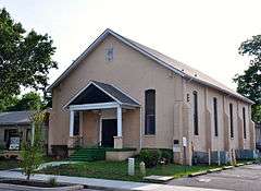
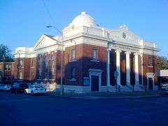
| 1 |
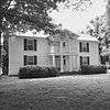
Allen Chapel A.M.E. Church |
|
000000001995-03-31-0000March 31, 1995
(#95000291) |
224 S. Maney Ave.
35°50′38″N 86°23′14″W / 35.843889°N 86.387222°W / 35.843889; -86.387222 (Allen Chapel A.M.E. Church) |
Murfreesboro |
|
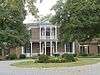
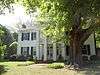
| 2 |
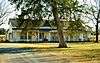
Arnold-Harrell House |
|
000000001992-03-27-0000March 27, 1992
(#92000145) |
1710 E. Main St.
35°50′26″N 86°21′51″W / 35.840556°N 86.364167°W / 35.840556; -86.364167 (Arnold-Harrell House) |
Murfreesboro |
|
| 3 |
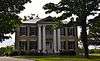
Beesley Primitive Baptist Church |
|
000000001999-04-08-0000April 8, 1999
(#99000397) |
461 Beesley Rd.
35°51′11″N 86°29′51″W / 35.853056°N 86.4975°W / 35.853056; -86.4975 (Beesley Primitive Baptist Church) |
Murfreesboro |
|
| 4 |
Thomas C. Black House |
Upload image |
000000001996-07-05-0000July 5, 1996
(#96000231) |
4431 Lebanon Rd.
35°55′38″N 86°22′58″W / 35.927222°N 86.382778°W / 35.927222; -86.382778 (Thomas C. Black House) |
Murfreesboro |
|
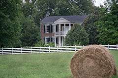
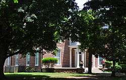
| 5 |
Boxwood |
|
000000001984-10-25-0000October 25, 1984
(#84000139) |
Old Salem Pike
35°48′37″N 86°27′09″W / 35.810278°N 86.4525°W / 35.810278; -86.4525 (Boxwood) |
Murfreesboro |
|
| 6 |
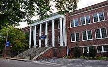
Bradley Academy |
|
000000001990-06-14-0000June 14, 1990
(#90000914) |
415 S. Academy St.
35°50′31″N 86°23′19″W / 35.841944°N 86.388611°W / 35.841944; -86.388611 (Bradley Academy) |
Murfreesboro |
School established 1811; current building completed in 1917
|
| 7 |
Caff-E-Hill Farm |
Upload image |
000000001995-04-14-0000April 14, 1995
(#95000412) |
3783 Cripple Creek Rd.
35°46′42″N 86°11′53″W / 35.778333°N 86.198056°W / 35.778333; -86.198056 (Caff-E-Hill Farm) |
Readyville |
|
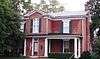
| 8 |
Childress-Ray House |
|
000000001979-12-27-0000December 27, 1979
(#79002458) |
225 N. Academy St.
35°50′51″N 86°23′19″W / 35.8475°N 86.388611°W / 35.8475; -86.388611 (Childress-Ray House) |
Murfreesboro |
Originally built 1847; remodeled 1874
|
| 9 |
Collier-Crichlow House |
|
000000001973-07-16-0000July 16, 1973
(#73001822) |
511 E. Main St.
35°50′42″N 86°22′18″W / 35.845°N 86.371667°W / 35.845; -86.371667 (Collier-Crichlow House) |
Murfreesboro |
Second Empire-style house built in 1879
|
| 10 |
Collier-Lane-Crichlow House |
|
000000001978-08-23-0000August 23, 1978
(#78002629) |
500 N. Spring St.
35°51′00″N 86°23′21″W / 35.85°N 86.389167°W / 35.85; -86.389167 (Collier-Lane-Crichlow House) |
Murfreesboro |
Commonly called the "House of Mayors"; built in 1850
|
| 11 |
Sam Davis House |
|
000000001969-12-23-0000December 23, 1969
(#69000181) |
Northeast of Smyrna off State Route 102
35°59′21″N 86°29′56″W / 35.989167°N 86.498889°W / 35.989167; -86.498889 (Sam Davis House) |
Smyrna |
|
| 12 |
Dement House |
Upload image |
000000001986-06-26-0000June 26, 1986
(#86001379) |
Cainsville Pike
35°55′56″N 86°16′01″W / 35.932222°N 86.266944°W / 35.932222; -86.266944 (Dement House) |
Lascassas |
|
| 13 |
East Main Street Historic District |
|
000000001985-07-11-0000July 11, 1985
(#85001516) |
Roughly E. Main, E. Lytle, College, University, and E. Vine Sts.
35°50′42″N 86°22′50″W / 35.845°N 86.380556°W / 35.845; -86.380556 (East Main Street Historic District) |
Murfreesboro |
|
| 14 |
Elmwood |
Upload image |
000000001973-10-15-0000October 15, 1973
(#73001823) |
Northwest of Murfreesboro off U.S. Routes 41/70S; also 5722 Old Nashville Highway
35°53′46″N 86°27′28″W / 35.896111°N 86.457778°W / 35.896111; -86.457778 (Elmwood) |
Murfreesboro |
5722 Old Nashville Highway represents a boundary increase of 000000002007-07-03-0000July 3, 2007
|
| 15 |
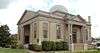
First Presbyterian Church |
|
000000001993-06-24-0000June 24, 1993
(#93000561) |
210 N. Spring St.
35°50′49″N 86°23′23″W / 35.846944°N 86.389722°W / 35.846944; -86.389722 (First Presbyterian Church) |
Murfreesboro |
|
| 16 |
Fortress Rosecrans Site |
|
000000001974-06-07-0000June 7, 1974
(#74001926) |
Old Fort Parkway
west of downtown Murfreesboro at the Stones River
35°51′12″N 86°24′41″W / 35.853333°N 86.411389°W / 35.853333; -86.411389 (Fortress Rosecrans Site) |
Murfreesboro |
|
| 17 |
Logan Henderson Farm |
|
000000002003-09-25-0000September 25, 2003
(#03000971) |
3600 Manchester Pike
35°47′27″N 86°21′25″W / 35.790833°N 86.356944°W / 35.790833; -86.356944 (Logan Henderson Farm) |
Murfreesboro |
|
| 18 |
Idler's Retreat |
|
000000002004-05-19-0000May 19, 2004
(#04000475) |
112 Oak St.
35°59′15″N 86°30′55″W / 35.9875°N 86.515278°W / 35.9875; -86.515278 (Idler's Retreat) |
Smyrna |
|
| 19 |
Jarman Farm |
|
000000001987-07-06-0000July 6, 1987
(#87001368) |
Cainsville Pike
35°57′46″N 86°15′30″W / 35.962778°N 86.258333°W / 35.962778; -86.258333 (Jarman Farm) |
Lascassas |
|
| 20 |
Enoch H. Jones House |
Upload image |
000000001995-08-25-0000August 25, 1995
(#95001043) |
6339 Halls Hill Pike
35°51′39″N 86°13′04″W / 35.860833°N 86.217778°W / 35.860833; -86.217778 (Enoch H. Jones House) |
Murfreesboro |
|
| 21 |
William B. Jordan Farm |
Upload image |
000000001992-07-13-0000July 13, 1992
(#92000825) |
2665 Taylor Ln.
35°46′03″N 86°36′10″W / 35.7675°N 86.602778°W / 35.7675; -86.602778 (William B. Jordan Farm) |
Eagleville |
|
| 22 |
Landsberger-Gerhardt House |
Upload image |
000000001993-12-13-0000December 13, 1993
(#93001397) |
435 N. Spring St.
35°51′00″N 86°23′21″W / 35.85°N 86.389167°W / 35.85; -86.389167 (Landsberger-Gerhardt House) |
Murfreesboro |
|
| 23 |
Uncle Dave Macon House |
|
000000001973-11-15-0000November 15, 1973
(#73001827) |
West of Readyville on U.S. Route 70S
35°49′27″N 86°14′27″W / 35.824167°N 86.240833°W / 35.824167; -86.240833 (Uncle Dave Macon House) |
Readyville |
Home of banjoist and showman Uncle Dave Macon
|
| 24 |
Marymont |
|
000000001973-10-30-0000October 30, 1973
(#73001824) |
Southwest of Murfreesboro, off State Route 99 on Rucker Lane
35°49′12″N 86°28′45″W / 35.82°N 86.479167°W / 35.82; -86.479167 (Marymont) |
Murfreesboro |
|
| 25 |
William Harrison McCord House |
Upload image |
000000001984-12-20-0000December 20, 1984
(#84001121) |
U.S. Route 41A
35°44′46″N 86°39′06″W / 35.746111°N 86.651667°W / 35.746111; -86.651667 (William Harrison McCord House) |
Eagleville |
|
| 26 |
McGill – Becton – Cates Family Farm |
Upload image |
000000002005-11-09-0000November 9, 2005
(#05001220) |
2432 Cripple Creek Rd.
35°47′03″N 86°12′41″W / 35.784167°N 86.211389°W / 35.784167; -86.211389 (McGill – Becton – Cates Family Farm) |
Readyville |
|
| 27 |
Middle Tennessee State Teachers College Training School |
|
000000001993-01-04-0000January 4, 1993
(#92001731) |
923 E. Lytle St.
35°50′49″N 86°22′31″W / 35.846944°N 86.375278°W / 35.846944; -86.375278 (Middle Tennessee State Teachers College Training School) |
Murfreesboro |
|
| 28 |
Morgan House |
|
000000001979-12-27-0000December 27, 1979
(#79002457) |
Southwest of Christiana
35°39′22″N 86°27′27″W / 35.656111°N 86.4575°W / 35.656111; -86.4575 (Morgan House) |
Christiana |
|
| 29 |
Murfreesboro Veterans Administration Hospital Historic District |
Upload image |
000000002012-03-12-0000March 12, 2012
(#12000119) |
3400 Lebanon Pike
35°55′00″N 86°22′41″W / 35.916625°N 86.378054°W / 35.916625; -86.378054 (Murfreesboro Veterans Administration Hospital Historic District) |
Murfreesboro |
United States Second Generation Veterans Hospitals Multiple Property Submission
|
| 30 |
Murray Farm |
Upload image |
000000001991-07-31-0000July 31, 1991
(#91000980) |
9409 Bradyville Rd.
35°45′21″N 86°15′49″W / 35.755833°N 86.263611°W / 35.755833; -86.263611 (Murray Farm) |
Readyville |
|
| 31 |
North Maney Avenue Historic District |
Upload image |
000000001985-04-04-0000April 4, 1985
(#85000709) |
Roughly bounded by N. Maney and N. Highland Aves., E. College St., and N. Academy Ave.
35°50′55″N 86°23′10″W / 35.848611°N 86.386111°W / 35.848611; -86.386111 (North Maney Avenue Historic District) |
Murfreesboro |
|
| 32 |
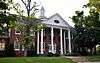
Oaklands |
|
000000001970-02-26-0000February 26, 1970
(#70000616) |
N. Maney Ave.
35°51′21″N 86°23′06″W / 35.855833°N 86.385°W / 35.855833; -86.385 (Oaklands) |
Murfreesboro |
|
| 33 |
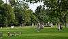
Old First Presbyterian Church and Old City Cemetery |
|
000000002012-03-12-0000March 12, 2012
(#12000120) |
390 E. Vine St.
35°50′37″N 86°23′16″W / 35.843508°N 86.387871°W / 35.843508; -86.387871 (Old First Presbyterian Church and Old City Cemetery) |
Murfreesboro |
Cemetery dating to the 1820s and site of the original First Presbyterian Church in Murfreesboro which was destroyed by Union Army troops during the American Civil War[6]
|
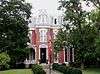
| 34 |
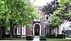
Gen. Joseph B. Palmer House |
|
000000001973-09-20-0000September 20, 1973
(#73001825) |
434 E. Main St.
35°50′43″N 86°23′07″W / 35.845278°N 86.385278°W / 35.845278; -86.385278 (Gen. Joseph B. Palmer House) |
Murfreesboro |
Built in 1869 by Confederate general Joseph B. Palmer (1825–1890)
|
| 35 |
Providence Primitive Baptist Church |
Upload image |
000000002000-11-08-0000November 8, 2000
(#00001357) |
256 Central Valley Rd.
35°56′19″N 86°22′51″W / 35.938611°N 86.380833°W / 35.938611; -86.380833 (Providence Primitive Baptist Church) |
Walterhill |
|
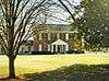
| 36 |
Charles Ready House |
|
000000001973-07-02-0000July 2, 1973
(#73001828) |
On U.S. Route 70S
35°49′45″N 86°10′47″W / 35.829167°N 86.179722°W / 35.829167; -86.179722 (Charles Ready House) |
Readyville |
Known as "The Corners," built in 1829 by Charles Ready
|
| 37 |
Riverside Farm |
Upload image |
000000002006-12-12-0000December 12, 2006
(#06001132) |
1218 W. Jefferson Pike
35°57′55″N 86°23′21″W / 35.965278°N 86.389167°W / 35.965278; -86.389167 (Riverside Farm) |
Walterhill |
|
| 38 |
Rockvale Store |
Upload image |
000000001995-09-14-0000September 14, 1995
(#95001114) |
8964 Rockvale Rd.
35°45′27″N 86°31′53″W / 35.7575°N 86.531389°W / 35.7575; -86.531389 (Rockvale Store) |
Rockvale |
|
| 39 |
Benjamine Rucker House |
Upload image |
000000001991-02-28-0000February 28, 1991
(#91000223) |
3978 Betty Ford Rd.
35°55′14″N 86°19′51″W / 35.920556°N 86.330833°W / 35.920556; -86.330833 (Benjamine Rucker House) |
Compton |
|
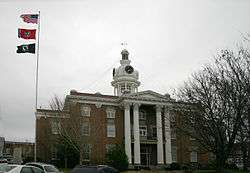
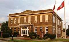
| 40 |
Rutherford County Courthouse |
|
000000001973-07-16-0000July 16, 1973
(#73001826) |
Public Square
35°50′46″N 86°23′31″W / 35.846111°N 86.391944°W / 35.846111; -86.391944 (Rutherford County Courthouse) |
Murfreesboro |
|
| 41 |
Rutherford Health Department |
|
000000001992-07-24-0000July 24, 1992
(#92000960) |
303 N. Church St.
35°50′54″N 86°23′27″W / 35.848333°N 86.390833°W / 35.848333; -86.390833 (Rutherford Health Department) |
Murfreesboro |
|
| 42 |
Absalom Scales House |
Upload image |
000000001973-10-30-0000October 30, 1973
(#73001821) |
North of Eagleville off State Route 16, on Rocky Glade Rd.
35°46′27″N 86°38′22″W / 35.774167°N 86.639444°W / 35.774167; -86.639444 (Absalom Scales House) |
Eagleville |
|
| 43 |
Searcy – Matthews – Tarpley Farm |
Upload image |
000000002011-07-14-0000July 14, 2011
(#11000459) |
455 W. Jefferson Pike
35°57′08″N 86°23′07″W / 35.952222°N 86.385278°W / 35.952222; -86.385278 (Searcy – Matthews – Tarpley Farm) |
Walterhill |
Historic Family Farms in Middle Tennessee MPS
|
| 44 |
Robert Andrew Smith Farm |
Upload image |
000000001993-01-04-0000January 4, 1993
(#92001712) |
2568 Armstrong Valley Rd.
35°46′06″N 86°28′45″W / 35.768333°N 86.479167°W / 35.768333; -86.479167 (Robert Andrew Smith Farm) |
Murfreesboro |
|
| 45 |
John C. Spence House |
|
000000002004-08-23-0000August 23, 2004
(#04000302) |
503 N. Maple St.
35°51′10″N 86°23′32″W / 35.852778°N 86.392222°W / 35.852778; -86.392222 (John C. Spence House) |
Murfreesboro |
|
| 46 |
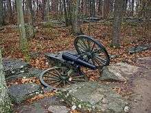
Stones River National Battlefield |
|
000000001966-10-15-0000October 15, 1966
(#66000075) |
3 miles (4.8 km) northwest of Murfreesboro on U.S. Route 41
35°52′24″N 86°25′17″W / 35.873333°N 86.421389°W / 35.873333; -86.421389 (Stones River National Battlefield) |
Murfreesboro |
|
| 47 |
Walter Hill Hydroelectric Station |
Upload image |
000000001990-11-07-0000November 7, 1990
(#90001660) |
U.S. Route 231 at the Stones River
35°56′37″N 86°22′37″W / 35.943611°N 86.376944°W / 35.943611; -86.376944 (Walter Hill Hydroelectric Station) |
Murfreesboro |
|


.jpg)