National Register of Historic Places listings in Lawrence County, Tennessee
Location of Lawrence County in Tennessee
This is a list of the National Register of Historic Places listings in Lawrence County, Tennessee.
This is intended to be a complete list of the properties and districts on the National Register of Historic Places in Lawrence County, Tennessee, United States. Latitude and longitude coordinates are provided for many National Register properties and districts; these locations may be seen together in a map.[1]
There are 13 properties and districts listed on the National Register in the county.
| Anderson – Bedford – Benton – Bledsoe – Blount – Bradley – Campbell – Cannon – Carroll – Carter – Cheatham – Chester – Claiborne – Clay – Cocke – Coffee – Crockett – Cumberland – Davidson – Decatur – DeKalb – Dickson – Dyer – Fayette – Fentress – Franklin – Gibson – Giles – Grainger – Greene – Grundy – Hamblen – Hamilton – Hancock – Hardeman – Hardin – Hawkins – Haywood – Henderson – Henry – Hickman – Houston – Humphreys – Jackson – Jefferson – Johnson – Knox – Lake – Lauderdale – Lawrence – Lewis – Lincoln – Loudon – Macon – Madison – Marion – Marshall – Maury – McMinn – McNairy – Meigs – Monroe – Montgomery – Moore – Morgan – Obion – Overton – Perry – Pickett – Polk – Putnam – Rhea – Roane – Robertson – Rutherford – Scott – Sequatchie – Sevier – Shelby – Smith – Stewart – Sullivan – Sumner – Tipton – Trousdale – Unicoi – Union – Van Buren – Warren – Washington – Wayne – Weakley – White – Williamson – Wilson |
- This National Park Service list is complete through NPS recent listings posted December 2, 2016.[2]
Current listings
| [3] | Name on the Register[4] | Image | Date listed[5] | Location | City or town | Description |
|---|---|---|---|---|---|---|
| 1 | Crockett Theater | 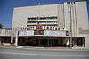 |
(#97000804) |
205 N. Military Ave. 35°14′31″N 87°20′04″W / 35.241944°N 87.334444°W |
Lawrenceburg | |
| 2 | Garrett House | .JPG) |
(#09000137) |
205 S. Military Ave. 35°14′22″N 87°20′09″W / 35.23951°N 87.33596°W |
Lawrenceburg | |
| 3 | T.D. Davenport Forge (40LR7) | Upload image | (#88001101) |
Address Restricted |
Lawrenceburg | |
| 4 | Lawrence County Jail | 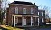 |
(#76001784) |
Waterloo St. 35°14′28″N 87°20′15″W / 35.241111°N 87.3375°W |
Lawrenceburg | |
| 5 | Lawrenceburg Commercial Historic District | 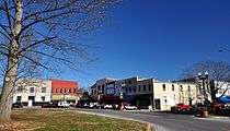 |
(#92000346) |
Roughly bounded by N. Military St., Public Sq., E. Gaines St., and E. Pulaski St. 35°14′29″N 87°20′04″W / 35.241389°N 87.334444°W |
Lawrenceburg | |
| 6 | Lawrenceburg No. 1 Hydroelectric Station | Upload image | (#90000308) |
Glen Spring Rd. at Horseshoe Bend of Little Shoal Creek 35°13′43″N 87°21′29″W / 35.228611°N 87.358056°W |
Lawrenceburg | |
| 7 | Lawrenceburg No. 2 Hydroelectric Station | Upload image | (#90001005) |
Mile 51.7 on Shoal Creek near Old U.S. Route 43 35°12′55″N 87°21′47″W / 35.215278°N 87.363056°W |
Lawrenceburg | |
| 8 | Mount Zion Methodist Episcopal Church South |  |
(#88000201) |
Mount Zion Rd. Coordinates missing |
Fall River | |
| 9 | Old Natchez Trace |  |
(#75002125) |
From the Alabama/Tennessee border to State Route 100 in Davidson County Coordinates missing |
N.A. | Extends into Davidson, Hickman, Lewis, Maury, Wayne, and Williamson counties |
| 10 | Sacred Heart of Jesus Church | .JPG) |
(#84000093) |
Berger St. 35°14′46″N 87°20′07″W / 35.246111°N 87.335278°W |
Lawrenceburg | |
| 11 | Sacred Heart of Jesus Church |  |
(#84000094) |
Church St. 35°04′36″N 87°26′36″W / 35.076667°N 87.443333°W |
Loretto | Built in 1912 |
| 12 | St. Joseph Church | Upload image | (#84000113) |
Spring St. 35°01′59″N 87°30′11″W / 35.033056°N 87.503056°W |
St. Joseph | |
| 13 | St. Mary's Cemetery | Upload image | (#84000095) |
off Rascal Town Rd. 35°01′53″N 87°24′53″W / 35.031389°N 87.414722°W |
Former listings
One other property was once listed, but has since been removed.
| [3] | Name on the Register | Image | Date listed | Date removed | Location | City or town | Summary |
|---|---|---|---|---|---|---|---|
| 1 | Garner Mill | Upload image | (#84003575) | Garner Lane |
Lawrenceburg | Destroyed by flooding in 1998 |
See also
| Wikimedia Commons has media related to National Register of Historic Places in Lawrence County, Tennessee. |
- List of National Historic Landmarks in Tennessee
- National Register of Historic Places listings in Tennessee
References
- ↑ The latitude and longitude information provided in this table was derived originally from the National Register Information System, which has been found to be fairly accurate for about 99% of listings. For about 1% of NRIS original coordinates, experience has shown that one or both coordinates are typos or otherwise extremely far off; some corrections may have been made. A more subtle problem causes many locations to be off by up to 150 yards, depending on location in the country: most NRIS coordinates were derived from tracing out latitude and longitudes off of USGS topographical quadrant maps created under the North American Datum of 1927, which differs from the current, highly accurate WGS84 GPS system used by most on-line maps. Chicago is about right, but NRIS longitudes in Washington are higher by about 4.5 seconds, and are lower by about 2.0 seconds in Maine. Latitudes differ by about 1.0 second in Florida. Some locations in this table may have been corrected to current GPS standards.
- ↑ "National Register of Historic Places: Weekly List Actions". National Park Service, United States Department of the Interior. Retrieved on December 2, 2016.
- 1 2 Numbers represent an ordering by significant words. Various colorings, defined here, differentiate National Historic Landmarks and historic districts from other NRHP buildings, structures, sites or objects.
- ↑ National Park Service (2008-04-24). "National Register Information System". National Register of Historic Places. National Park Service.
- ↑ The eight-digit number below each date is the number assigned to each location in the National Register Information System database, which can be viewed by clicking the number.
| Topics | |
|---|---|
| Lists by states |
|
| Lists by insular areas | |
| Lists by associated states | |
| Other areas | |
| |
Municipalities and communities of Lawrence County, Tennessee, United States | ||
|---|---|---|
| Cities | ||
| Town | ||
| CDPs | ||
| Other unincorporated communities | ||
| Ghost town | ||
| Footnotes | ‡This populated place also has portions in an adjacent county or counties | |
This article is issued from Wikipedia - version of the 11/3/2016. The text is available under the Creative Commons Attribution/Share Alike but additional terms may apply for the media files.