Tennessee State Route 61
| ||||
|---|---|---|---|---|
| Route information | ||||
| Maintained by TDOT | ||||
| Length: | 81.67 mi (131.44 km) | |||
| Major junctions | ||||
| West end: |
| |||
|
| ||||
| East end: |
| |||
| Location | ||||
| Counties: | Roane, Anderson, Union, Knox, Grainger | |||
| Highway system | ||||
| ||||


State Route 61 is a west-to-east highway in the U.S. state of Tennessee that is 69 miles (111 km) long.
State Route 61 begins in Roane County, and it ends in Grainger County.
Counties traversed (west to east)
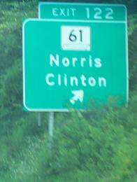
Sign on Interstate 75 for TN 61.
State Route 61 traverses the counties shown in the table below.
| Counties traversed by State Route 61 | ||
|---|---|---|
| County | miles | kilometers |
| Roane | 18.2 | 29.3 |
| Anderson | 28.3 | 45.5 |
| Knox | 1.6 | 2.6 |
| Grainger | 1.2 | 2.0 |
| Union | 19.9 | 32.0 |
Junction list
| County | Location | mi | km | Destinations | Notes |
|---|---|---|---|---|---|
| Roane | Rockwood | 0.00 | 0.00 | Western terminus; Western end of US 27 overlap; SR 61 begins as a primary state route | |
| Northern terminus of SR 382 | |||||
| Harriman | I-40 exit, 347 | ||||
| Western end of SR 29 overlap | |||||
| Southern terminus of SR 328 | |||||
| | Eastern end of US 27/SR 29 overlap | ||||
| Blair | Northern terminus of SR 327 | ||||
| Oliver Springs | Western end of SR 62 concurrency; Southern terminus of SR 330 | ||||
| Anderson | Downtown Oliver Springs To | Westbound Interchange only; No Eastbound access | |||
| Eastern end of SR 62 concurrency | |||||
| Oak Ridge | Northern terminus of SR 95 | ||||
| Clinton | |||||
| I-75, exit 122; SR 61 changes from a primary route to a secondary route | |||||
| Norris | Western end of US 441/SR 71 concurrency | ||||
| Eastern end of US 441/SR 71 concurrency | |||||
| Union | New Loyston | Western/Eastern end of SR 170 wrong-way concurrency | |||
| Eastern/Western end of SR 170 wrong-way concurrency | |||||
| Paulette | Western end of SR 33 concurrency | ||||
| Maynardville | Western end of SR 144 concurrency | ||||
| Eastern end of SR 144 concurrency | |||||
| Eastern end of SR 33 concurrency | |||||
| | Northern terminus of SR 370 | ||||
| Luttrell | Western end of SR 131 concurrency | ||||
| Eastern end of SR 131 concurrency | |||||
| Knox | Corryton | Northern terminus of SR 331 | |||
| Grainger | Blaine | Eastern terminus of SR 61; SR 61 ends as a secondary route | |||
1.000 mi = 1.609 km; 1.000 km = 0.621 mi
| |||||
See also
References
- Tennessee Department of Transportation (24 January 2003). "State Highway and Interstate List 2003".
External links
This article is issued from Wikipedia - version of the 6/2/2016. The text is available under the Creative Commons Attribution/Share Alike but additional terms may apply for the media files.