Mizoram
| Mizoram | ||
|---|---|---|
| State | ||
| ||
 | ||
| Coordinates (Aizawl): 23°22′N 92°48′E / 23.36°N 92.8°ECoordinates: 23°22′N 92°48′E / 23.36°N 92.8°E | ||
| Formation | 20 February 1987† | |
| Capital | Aizawl | |
| Largest city | Aizawl | |
| Districts | 8 | |
| Government | ||
| • Governor | Lt General Nirbhay Sharma [1] | |
| • Chief Minister | Pu Lalthanhawla (INC) | |
| • Legislature | Unicameral (40 seats) | |
| • Parliamentary constituency | 1 | |
| • High Court | Gauhati High Court | |
| Area | ||
| • Total | 21,087 km2 (8,142 sq mi) | |
| Area rank | 25th | |
| Population (2011) | ||
| • Total | 1,091,014 | |
| • Rank | 28th | |
| • Density | 52/km2 (130/sq mi) | |
| Time zone | IST (UTC+05:30) | |
| ISO 3166 code | IN-MZ | |
| Literacy | 91.58%[2](3rd)2011 Census | |
| Official language | Mizo, English, Hindi[3] | |
| Website | mizoram.gov.in | |
| †It was elevated to the status of a full State by the State of Mizoram Act, 1986 | ||

Mizoram (English pronunciation: ![]() i/mɪˈzɔərəm/) is one of the states of Northeast India, with Aizawl as its capital city. The name is derived from Mi (people), Zo (lofty place, such as a hill) and Ram (land), and thus Mizoram implies "land of the hill people".[4] In the northeast, it is the southern most landlocked state sharing borders with three of the Seven, now with the addition of Sikkim, Eight sister states, namely Tripura, Assam, Manipur. The state also shares a 722 kilometre border with the neighbouring countries of Bangladesh and Myanmar.[5]
i/mɪˈzɔərəm/) is one of the states of Northeast India, with Aizawl as its capital city. The name is derived from Mi (people), Zo (lofty place, such as a hill) and Ram (land), and thus Mizoram implies "land of the hill people".[4] In the northeast, it is the southern most landlocked state sharing borders with three of the Seven, now with the addition of Sikkim, Eight sister states, namely Tripura, Assam, Manipur. The state also shares a 722 kilometre border with the neighbouring countries of Bangladesh and Myanmar.[5]
Like several other northeastern states of India, Mizoram was previously part of Assam until 1972, when it was carved out as a Union Territory. It became the 23rd state of India, a step above Union Territory, on 20 February 1987.[6]
Mizoram's population was 1,091,014, according to a 2011 census. It is the 2nd least populous state in the country.[7] Mizoram covers an area of approximately 21,087 square kilometres.[8] About 91% of the state is forested.[9]
About 95% of current Mizoram population is of diverse tribal origins who settled in the state, mostly from southeast Asia, over waves of migration starting about 16th century but mainly in 18th century.[10] This is the highest concentration of tribal people among all states of India, and they are currently protected under Indian constitution as a Scheduled Tribe.[11] The tribes converted from Animist religions to Christianity over the first half of 20th century. Mizoram is one of three states of India with a Christian majority (87%).[12] Its people belong to various denominations, mostly Presbyterian in its north and Baptists in south.
Mizoram is a highly literate agrarian economy, but suffers from slash-and-burn jhum or shifting cultivation, and poor crop yields.[13] In recent years, the jhum farming practices are steadily being replaced with a significant horticulture and bamboo products industry.[14][15] The state's gross state domestic product for 2012 was estimated at ₹6,991 crore (US$1.0 billion).[8] About 20% of Mizoram's population lives below poverty line, with 35% rural poverty.[16] The state has about 871 kilometres of national highways, with NH-54 and NH-150 connecting it to Assam and Manipur respectively. It is also a growing transit point for trade with Myanmar and Bangladesh.[17]
Etymology
The term Mizoram is derived from three Mizo words-Mi, zo and ram. 'Mi' in Mizo means 'People' and 'Ram' means 'land'. There is dispute on the term 'zo'. According to one view, 'zo' means 'highland' (or hill) and Mizoram means 'land of the hill people'. B. Lalthangliana says 'zo' may also mean 'cold region' and therefore, Mizo signifies people of the cold region.[18]
History

The origin of the Mizos, like those of many other tribes in the northeastern India, is shrouded in mystery. The people living in the Mizo Hills were generally referred to as the cucis or kukis by their neighbouring ethnic groups which was also a term adopted by the British writers. The claim that 'The Kukis are the earliest known residents of the Mizo hills area,' must be read in this light.[20] The majority of the tribes classified as "Mizo" today most likely migrated to their present territories from the neighbouring countries in several waves, starting around 1500 CE.[21]
Before the British Raj, the various Mizo clans lived in autonomous villages. The tribal chiefs enjoyed an eminent position in the gerontocratic Mizo society. The various clans and subclans practised slash-and-burn, locally called jhum cultivation - a form of subsistence agriculture.[22] The chiefs were the absolute rulers of their respective clans' territories (ram), although they remained under the nominal political jurisdictions of the Rajas of Manipur, Tripura and Burma.[23] There were many instances of tribal raids and head-hunting led by the village chieftains. Head-hunting was a practice which involved ambushing, taking slaves and cutting off the heads of fighters from the enemy tribe, bringing it back, and displaying it at the entrance of the tribal village.[24]
British era (1840s to 1940s)
Some of the earliest records of raids and intertribal conflicts are from early 19th century.[19] Captain Blackwood of Britain in 1840s, during colonial times, marched into Mizo hills with his troops to punish a Palian tribal chief for raiding British interests in India. Few years later, Captain Lester was wounded in a battle with Lusei tribe in the region that is now Mizoram. In 1849, a Lusei tribe raid killed 29 Thahdos tribe people and added 42 captives to their clan. Colonel Lister responded in 1850, with co-operation of Thahdos tribe, against Lusei tribe, historically called the First British invasion, burning down a village of 800 tribal houses and freeing 400 Thahdos captives.[19][25] British historical records on Mizo hills state similar inter-ethnic tribal raids for loot, slaves and retaliatory battles continued for decades.[26]
The Mizo Hills formally became part of British India in 1895, and practices such as head-hunting were banned in Mizoram as well as neighbouring regions.[27] North and south Mizo hills became part of the Assam province in 1898 as the Lushai Hills District, with Aizawl as headquarters.[28] At the time of the British conquest, there were around 60 chiefs.[23] After Christian missionaries arrived with the gospel of Jesus Christ, majority of the population became Christians over a period of time in first half of 20th century.
Post 1947
By the time India gained independence from the British empire, the number of tribal chiefs had increased to over 200. The educated elites among the Mizos campaigned against the tribal chiefdom under the banner of Mizo Union. As a result of their campaign, the hereditary rights of the 259 chiefs were abolished under the Assam-Lushai District (Acquisition of Chief's Rights) Act, 1954.[23][26] Village courts were re-implemented in Mizo region along with other parts of Assam. All of these regions were frustrated by these arrangements and centralised Assam governance. The Mizos were particularly dissatisfied with the government's inadequate response to the 1959–60 mautam famine. The Mizo National Famine Front, a body formed for famine relief in 1959, later developed into a new political organisation, the Mizo National Front (MNF) in 1961.[29] A period of protests and armed insurgency followed in 1960s, with MNF seeking independence from India.[30]
In 1971, the government agreed to convert the Mizo Hills into a Union Territory, which came into being as Mizoram in 1972. Following the Mizoram Peace Accord (1986) between the Government and the MNF, Mizoram was declared a full-fledged state of India in 1987.[31] Mizoram got two seats in the Parliament, one each in the Lok Sabha and in the Rajya Sabha.[32] The region has been peaceful in recent decades. Between 2006 and 2013, between 0 and 2 civilians have died each year from any protest-related violence (or less than 0.2 people per 100,000).[33] The world's average annual death rate from intentional violence, in recent years, has been 7.9 per 100,000 people.[34]
Geography
Mizoram is a landlocked state in North East India whose southern part shares 722[8] kilometres long international borders with Myanmar and Bangladesh, and northern part share domestic borders with Manipur, Assam and Tripura. It is the fifth smallest state of India with 21,087 km2 (8,142 sq mi). It extends from 21°56'N to 24°31'N, and 92°16'E to 93°26'E.[35] The tropic of cancer runs through the state nearly at its middle. The maximum north-south distance is 285 km, while maximum east-west stretch is 115 km.[35]

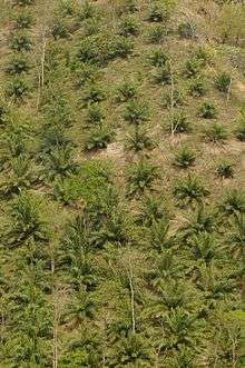
Mizoram is a land of rolling hills, valleys, rivers and lakes. As many as 21 major hill ranges or peaks of different heights run through the length and breadth of the state, with plains scattered here and there. The average height of the hills to the west of the state are about 1,000 metres (3,300 ft). These gradually rise up to 1,300 metres (4,300 ft) to the east. Some areas, however, have higher ranges which go up to a height of over 2,000 metres (6,600 ft). Phawngpui Tlang also known as the Blue Mountain, situated in the south-eastern part of the state, is the highest peak in Mizoram at 2,210 metres (7,250 ft).[36] About 76% of the state is covered by forests, 8% is fallows land, 3% is barren and considered uncultivable area, while cultivable and sown area constitutes the rest.[37] Slash-and-burn or jhum cultivation, though discouraged, remains in practice in Mizoram and affects its topography.[38][39] As per state of forest report 2015 states with maximum forest cover as percentage of their own geographical area. Mizoram being the highest 88.93% Forest.[40]

Mizoram terrain is, according to Geological Survey of India, an immature topography, and the physiographic expression consists of several almost North-South longitudinal valleys containing series of small and flat hummocks, mostly anticlinal, parallel to sub-parallel hill ranges and narrow adjoining synclinal valleys with series of topographic highs. The general geology of western Mizoram consists of repetitive succession of Neogene sedimentary rocks of Surma Group and Tipam Formation viz. sandstone, siltstone, mudstone and rare pockets of shell limestone. The eastern part is Barail Group.[41] Mizoram, lies in seismic zone V, according to the India Meteorological Department; as with other northeastern states of India, this means the state has the highest risk of earthquakes relative to other parts of India.[42]
The biggest river in Mizoram is Chhimtuipui, also known as Kaladan, Kolodyne or Chimtuipui. It originates in Chin state in Burma and passes through Saiha and Lawngtlai districts in the southern tip of Mizoram, goes back to Burma's Rakhine state. Although many more rivers and streams drain the hill ranges, the most important and useful rivers are the Tlawng, Tut, Tuirial and Tuivawl which flow through the northern territory and eventually join the Barak River in Cachar District. The rivers have a gentle drainage gradient particularly in the south.[41]
The Palak lake is the biggest in Mizoram and covers 30 hectares (74 acres). The lake is situated in Saiha district of southern Mizoram. It is believed that the lake was created as a result of an earthquake or a flood. The local people believe that a submerged village remains intact deep under the waters. The Tam Dil lake is a natural lake situated 85 kilometres (53 mi) from Aizawl. Legend has it that a huge mustard plant once stood in this place. When the plant was cut down, jets of water sprayed from the plant and created a pool of water, thus the lake was named Ţam Dil which means of 'lake of mustard plant'. Today the lake is an important tourist attraction and a holiday resort. The most significant lake in Mizo history, Rih Dil, is ironically located in Burma, a few kilometres from the Indo-Burma border. It was believed that the departed souls pass through this lake before making their way to Pialral or heaven. Mizoram is also called as peninsula state as it has 3 sides covered with international land and one side covered with domestic land.
Climate
Mizoram has a mild climate, being relatively cool in summer 20 to 29 °C (68 to 84 °F) with winter temperatures ranging from 7 to 22 °C (45 to 72 °F). The region is influenced by monsoons, raining heavily from May to September with little rain in the dry (cold) season. The climate pattern is moist tropical to moist sub-tropical, with average state rainfall 254 centimetres (100 in) per annum. In the capital Aizawl, rainfall is about 215 centimetres (85 in) and in Lunglei, another major centre, about 350 centimetres (140 in).[41] The state is in a region where cyclones and landslides can cause weather-related emergencies.[43]
| Month | Jan | Feb | Mar | Apr | May | Jun | Jul | Aug | Sep | Oct | Nov | Dec | Year |
|---|---|---|---|---|---|---|---|---|---|---|---|---|---|
| Average high °C (°F) | 20.4 (68.7) |
21.7 (71.1) |
25.2 (77.4) |
26.8 (80.2) |
26.3 (79.3) |
25.5 (77.9) |
25.3 (77.5) |
25.5 (77.9) |
25.7 (78.3) |
24.7 (76.5) |
23.0 (73.4) |
21.0 (69.8) |
24.26 (75.67) |
| Average low °C (°F) | 11.4 (52.5) |
12.8 (55) |
15.6 (60.1) |
17.5 (63.5) |
18.1 (64.6) |
18.9 (66) |
19.1 (66.4) |
19.1 (66.4) |
19.2 (66.6) |
18.0 (64.4) |
15.1 (59.2) |
12.2 (54) |
16.42 (61.56) |
| Average precipitation mm (inches) | 13.4 (0.528) |
23.4 (0.921) |
73.4 (2.89) |
167.7 (6.602) |
289.0 (11.378) |
406.1 (15.988) |
320.4 (12.614) |
320.6 (12.622) |
305.2 (12.016) |
183.7 (7.232) |
43.2 (1.701) |
15.3 (0.602) |
2,161.4 (85.094) |
| Source: [44] | |||||||||||||
Biodiversity
| Animal | Serow(Saza) | |
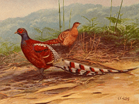
| Bird | Mrs. Hume's pheasant
(Vavu) | |
| Tree | Indian rose chestnut(Herhse) | |
| Flower | Red Vanda (Senhri) |  |
Mizoram has the third highest total forest cover with 1,594,000 hectares (3,940,000 acres), and highest percentage area (90.68%) covered by forests, among the states of India, according to 2011 Forest Survey of India.[9] Tropical Semi Evergreen, Tropical Moist Deciduous, Subtropical Broadleaved Hill and Subtropical Pine Forests are the common vegetation types found in Mizoram. Bamboo is common in the state, typically intermixed with other forest vegetation; about 9,245 km2 (44%) of state's area is bamboo bearing. The state and central governments of India have cooperated to reserve and protect 67% of the land covered by forests, and additional 15% by management. Only 17% of the land is non-forested area for cultivation, industry, mining, housing and other commercial human activity. Satellite data suggests 91% of state's geographical area is covered by forests.[9]
Jhum cultivation, or slash-and-burn practice, were a historic tradition in Mizoram and a threat to its forest cover. This practice has reduced in recent decades from a government supported initiative to support horticultural crops such as pineapple and banana plantations.[9]

Mizoram is host to numerous species of birds, wildlife and flora. About 640 species of birds have been identified in the state, many of which are endemic to Himalayan foothills and southeast Asia. Of the birds found in Mizoram forests, 27 are on worldwide threatened species list and 8 are on critically endangered list.[48] Prominent birds spotted in Mizoram include those from the families of Phasianidae, Anatidae, Ciconiidae, Threskiornithidae, Ardeidae, Pelecanidae, Phalacrocoracidae, Falconidae, Accipitridae, Otididae, Rallidae, Heliornithidae, Turnicidae, Burhinidae, Charadriidae, Scolopacidae, Jacanidae, Laridae, Columbidae, Psittacidae, Cuculidae, Strigidae, Caprimulgidae, Apodidae, Alcedinidae, Meropidae, Bucerotidae, Ramphastidae, Picidae, Pittidae, Laniidae, Campephagidae, Dicruridae, Corvidae, Paridae, Hirundinidae, Cisticolidae, Pycnonotidae, Sylviidae, Timaliidae, Sittidae, Sturnidae, Turdidae, Dicaedae, Chloropseidae, Ploceidae, Motacillidae, Fringillidae, Nectariniidae and Muscicapidae.[48] Each of these families have many species.
The state is also host to a variety of fauna, just like its sister northeastern Indian states. Mammal species observed in the Mizoram forests include slow loris (Nycticebus coucang), red serow; the state animal (Capricornis rubidus), goral (Nemorhaedus goral), tiger (Panthera tigris), leopard (Panthera pardus), clouded leopard ("Neofelis nebulosi"), leopard cat (Prionailurus bengalensis), and Asiatic black bear (Ursus thibetanus). Primates seen include stump-tailed macaque (Macaca arctoides), hoolock gibbon (Hylobates hoolock), Phayre's leaf monkey (Trachypithecus phayrei) and capped langur (Trachypithecus pileatus). The state is also home to many reptiles, amphibians, fish and invertebrates.[49][50]
The state has two national parks and six wildlife sanctuaries - Blue Mountain (Phawngpui) National Park, Dampa Tiger Reserve (largest), Lengteng Wildlife Sanctuary, Murlen National Park, Ngengpui Wildlife Sanctuary, Tawi Wildlife Sanctuary, Khawnglung Wildlife Sanctuary, and Thorangtlang Wildlife Sanctuary.[51]
Demographics
| Population growth | |||
|---|---|---|---|
| Census | Pop. | %± | |
| 1951 | 196,202 | — | |
| 1961 | 266,063 | 35.6% | |
| 1971 | 332,390 | 24.9% | |
| 1981 | 493,757 | 48.5% | |
| 1991 | 689,573 | 39.7% | |
| 2001 | 888,573 | 28.9% | |
| 2011 | 1,091,014 | 22.8% | |
| Source:Census of India[7] | |||
Mizoram has a population of 1,091,014 with 552,339 males and 538,675 females.[7] This reflects a 22.8% growth since 2001 census; still, Mizoram is second least populated state of India. The sex ratio of the state is 976 females per thousand males, higher than the national ratio 940. The density of population is 52 persons per square kilometre.[52]
The literacy rate of Mizoram in 2011 was 91.33 per cent,[52] higher than the national average 74.04 per cent, and second best among all the states of India. About 52% of Mizoram population lives in urban areas, much higher than India's average. Over one third of the population of Mizoram lives in Aizawl district, which hosts the capital.[7][53][54]
Ethnic groups
The great majority of Mizoram's population consists of several ethnic tribes who are either culturally or linguistically linked. These ethnic groups are collectively known as Mizos (Mi means People, Zo means Hill; Mizo thus is hillmen[26]). Mizo people are spread throughout the northeastern states of India, Burma and Bangladesh. They belong to numerous tribes; however, to name a particular tribe as the largest is difficult as no concrete census has ever been undertaken.
Sometime in 16th century CE, the first batch of Mizo crossed Tiau river and settled in Mizoram and they were called as Kukis by Bengalis.[55] The term Kuki mean the inhabitants of the interior and inaccessible mountain tracts. Sometimes grouped as Kuki-Chin tribes,The First batch were called Old Kukis which are the Biate and the Hrangkhol and the second batch that followed include Lushei (or Lusei), Paite, Lai, Mara, Ralte,Hmar, Thadou, Shendus, and several other.[55] These tribes are subdivided into numerous clans, and these clans are further sub-divided into sub-clans, for example the Hmars are divided into Thiek, Faihriem, Lungtau, Darngawn, Khawbung, Zote and others. These clans sometimes have slight liguistics differences. The Bru (Reang), Chakma, Tanchangya, Chin origin of Northern Arakan Mountain, are some non-Kuki tribes of Mizoram, with some suggestion that some of these are Indo-Aryan in their origins.[55] The Bnei Menashe tribe claim Jewish descent.[56]
The diversity of tribal groups reflects the historical immigration patterns. Different tribes and sub-tribes arrived in the present Mizoram, in successive waves and settled down in different parts of the state. Further, as they arrived, there were raids, fear of raids and intertribal feuds. The resulting isolation and separation created numerous tribes and sub-tribes.[55] The Mizo people usually suffix their descriptive given names with their tribe.
Other than tribal groups, other ethnic groups inhabit Mizoram. For example, Nepali Gorkhas were encouraged to settle in Aizawl area and other parts of Mizoram during the British colonial times. Thousands of their descendants are now residents of Mizoram.[57]
Protected demographic category
According to 2011 census, Mizoram had 1,036,115 people (95% of total) classified as Scheduled Tribe, the highest concentration of protected tribal people in all states of India.[11][58] This demographic classification, given to Mizoram tribes since 1950s, has provided reservations and extra resources in education and government job opportunities, a preferential treatment as a means to accelerate their integration with mainstream society.[59]
Languages

Mizo is the official language and the most widely used language for verbal interactions, but English, being important for education, administration, formalities and governance, is widely used. The Duhlian dialect, also known as the Lusei, was the first language of Mizoram and has come to be known as the Mizo language. The language is mixed with other dialects like the Hmar, Mara, Lai, Thadou, Paite, Gangte, etc. Christian missionaries developed the Mizo script. Writing is a combination of the Roman script and Hunterian transliteration methodology with prominent traces of a phonetics-based spelling system. There are 25 letters in the alphabet: A, AW, B, CH, D, E, F, G, NG, H, I, J, K, L, M, N, O, P, R, S, T, Ṭ, U, V, Z. Mizo is one of the languages with official status in India (at the state level). Nepali is also spoken by Nepali immigrants to the state.
The major languages spoken as per census 2001 are Mizo (650,605), Chakma (80,389), Lakher (34,731), Pawi (24,900), Tripuri (17,580), Hmar (14,240), Paite (14,367), etc.
Religion
The majority (87%) of Mizos are Christians in various denominations, predominantly Presbyterian. Mizoram has a Chakma Theravada Buddhist population of 8.5%, making them the largest minority, followed by Hindus at 2.7% according to the 2011 census.[63] There are several thousand people, mostly ethnic Mizo, who have converted to Judaism claiming to be one of the lost Judaic tribe group Bnei Menashe, with descent from the biblical Menasseh.[56] Muslims make up about 1.3% of the state population. The remaining 3,000 people are Sikhs, Jains and other religions.
- Christianity

The major Christian denomination is Mizoram Presbyterian Church which was established by a Welsh Missionary Rev. D.E. Jones starting with 1894.[65] By the time India gained independence from British Empire, some 80% of Lushei tribe people had converted to Christianity.[66] The Mizoram Presbyterian Church is one of the constituted bodies of the General Assembly of the Presbyterian Church of India at Shillong in Meghalaya; it became the dominant sect of Christianity in north Mizoram hills; In the southern hills of Mizoram, the Baptist Church had the dominant following.[66] Other Christian cults present in Mizoram include the United Pentecostal Church, the Salvation Army, the Seventh-day Adventist Church, Kohhran Thianghlim, Roman Catholic, Lairam Isua Krista Baptist Kohhran (LIKBK), Congregational Church of India (Maraland), Evangelical Church of Maraland, Independent Church of India (ICI) and Evangelical Free Church of India (EFCI).
- Buddhism
According to 2001 census report there are more than 70,494 people who follow Buddhism in Mizoram. The Chakmas and Tongchangya or Tanchangya have been Buddhist since historical times and there are approximately one hundred monasteries (known as vihara in Pali) in Mizoram. Of the many schools of Buddhism that existed in ancient times only Theravada Buddhism exists in Mizoram.
- Hinduism
According to the 2001 census, there were 31,562 Hindus in Mizoram, or about 3.55%. Out of this, 26,448 were non-indigenous and 5,114 were indigenous tribal. Earlier there were significant Hindu population among the Reang (Bru) communities, but after the ethnic riots of the 1990s, many of them migrated to Tripura and Assam. In 1961, the Hindu population was about 6%.[66]
- Others
There are also a few Mizos who practice Judaism (866 according to the 2001 census) and a modernised traditional Mizo religion called Hnam sakhua, which puts a particular emphasis on Mizo culture and seeks to revive traditional Mizo values, while at the same time attacking the influence brought about by Christianity on Mizo people.
A total of 1,367 people practised the Mizo religion according to the 2001 census. This number included, in addition to the original Mizo religion (755 people), adherents of other tribal religions such as Lalchhungkua (279), Lalhnam (122), and Nunna Lalchhungkua (211).[67]
Politics

Originally village land, locally called ram, was the property of the tribal chief. The institution of chieftainship began in the 16th century. Each village behaved like a small state, and the chief was called Lal. The rule was hereditary, and there were no written laws (the first script for Mizo language was developed by Christian missionaries Lorraine and Savidge about 1895).[26]
After annexation by the British in the 1890s, northern part of Mizoram was administered as the Lushai Hills district of Assam, while southern Mizoram was part of Bengal. In 1898, the southern part was transferred from Bengal to Assam. The colonial power retained the chiefs and Mizo customs, including the socially stratified hereditary transfer of political power. In 1937, under Section 6 of the Scheduled District Act, the British administration[26] consolidated executive and legislative political power to the Deputy Commissioner and District Magistrates, with village chiefs in advisory role. The political and judiciary powers of chiefs were neither final nor exclusive, thereafter. Rulings could be appealed to courts staffed with British officials. After India gained independence from the colonial rule, the region was granted autonomous status in 1952, where Mizo people formulated their own laws and delivered judicial decisions. The region was renamed as Mizo District within Assam State in April 1954 and in that year, the institution of hereditary chieftainship was abolished, and instead village courts/council were set up.[26] In the same year the Young Mizo Association was formed which is still an important institution in Mizoram.
The representatives of the Lushai Hills Autonomous District Council and the Mizo Union pleaded with the States Reorganisation Commission (SRC) to integrate the Mizo-dominated areas of Tripura and Manipur with the District Council in Assam. The tribal leaders in the northeast were unhappy with the final SRC recommendations and met in Aizawl in 1955 to form a new political party, Eastern India Tribal Union (EITU).[30] This group raised their demand for a separate state comprising all the hill districts of Assam. However, the demand was not accepted by the Government.

In the 1950s, the fears of Assamese hegemony and perceived lack of government concern led to growing discontent among the Mizos. The Mizos were particularly dissatisfied with the government's inadequate response to the 1959–60 mautam famine. The Mizo National Famine Front, a body formed for famine relief in 1959, later developed into a new political organisation, the Mizo National Front (MNF) in 1961.[29] The Front sought sovereign independence for the Mizo territory, staging an armed insurrection with the 28 February 1966 uprising against the government.[30] The revolt was suppressed by the Government of India, which carried out airstrikes in Aizawl and surrounding areas.[69][70] The secessionist Mizo National Front was outlawed in 1967, as the Mizo Union and other organisations continued the demand for a separate Mizo state within the Republic of India.
Assam state was split, re-organised into multiple political regions, Mizo hills area was declared Mizoram after the insurgency, and it received status as a Union Territory in 1972.[26] A Peace Accord was signed between central government and insurgent groups of Mizoram on 30 June 1986. Per the accord, insurgents surrendered their arms and Mizoram became the 23rd state of India in 1986, formalised the following year. The first election of Mizoram Legislative Assembly was held on 16 February 1987.[26] Elections have been held at 5 year intervals since then. The most recent Mizoram elections were held for 40 seats of legislative assembly on 25 November 2013. The voter turnout was 81%. The Indian National Congress led by Lal Thanhawla was re-elected to power.[71]
Lt General Nirbhay Sharma (Retd) is the Governor of Mizoram.
Administration
| District[72] | Population (2011) |
Population Density per km2 |
|---|---|---|
| Aizawl | 400,309 | 117 |
| Lunglei | 161,428 | 35 |
| Champhai | 125,745 | 37 |
| Lawngtlai | 117,894 | 39 |
| Mamit | 86,364 | 29 |
| Kolasib | 83,955 | 56 |
| Serchhip | 64,937 | 47 |
| Saiha | 56,574 | 52 |

The Mizoram State Legislative Assembly has 40 seats and the Village Councils are the grassroots of democracy and leadership in Mizoram. The state has a chief minister, council of ministers with a portfolio of ministries responsible for different priorities and role of the government.[73]
There are three Autonomous District Councils (ADCs) for ethnic tribes in Mizoram, namely Chakma Autonomous District Council (in the southern part of state, bordering Bangladesh), Lai Autonomous District Council (LADC) for Lai people in the southern part of the state, and Mara Autonomous District Council (MADC) for Mara people in the southern-eastern corner.
There are eight districts in Mizoram. A district of Mizoram is headed by a Deputy Commissioner who is in charge of the administration in that particular district. The Deputy Commissioner is the executive head of the district, responsible for implementing government regulations, the law and order situation in the district, as well as being responsible for tax collection for the government.[74]
A Superintendent of Police is responsible for the police administration of each district.[74] These officials work with the village councils in each district.
Economy

Mizoram gross state domestic product (GSDP) in 2011-2012 was about ₹6,991 crore (US$1.0 billion).[8] The state's gross state domestic product (GSDP) growth rate was nearly 10% annually over 2001-2013 period. With international borders with Bangladesh and Myanmar, it is an important port state for southeast Asian imports to India, as well as exports from India.[17]
The biggest contributors to state's GSDP growth are Agriculture, Public Administration and Construction work.[75] Tertiary sector of service sector continued to have the contribution to the GSDP with its share hovering between 58 per cent and 60 per cent during the past decade.[17][76]
As of 2013, according to the Reserve Bank of India, 20.4% of total state population is below poverty line, about same as the 21.9% average for India. Rural poverty is significantly higher in Mizoram, with 35.4% below the poverty line compared to India's rural poverty average of 25.7; while in urban areas of Mizoram, 6.4% are below the poverty line.[16]
Mizoram has a highly literate work force, with literacy rate of nearly 90% and widespread use of English. The state has a total of 4,300 kilometres of roads of which 927 kilometres are high quality national highways and 700 kilometres of state highways. The state is developing its Kolodyne river for navigation and international trade. Mizoram's airport is at the capital city of Aizawl. The state is a power deficit state, with plans to develop its hydroelectric potential. After agriculture, the major employer of its people include handloom and horticulture industries. Tourism is a growth industry. In 2008, the state had nearly 7,000 registered companies. The state government has been implementing Special Economic Zones (SEZs) to encourage economic growth.[15]
Agriculture

Between 55% to 60% of the working population of the state is annually deployed on agriculture.[13][14] The sector's contribution to the gross state domestic product was 30% in 1994, just 14% in 2009 due to economic growth of other sectors.[77]
Agriculture has traditionally been a subsistence profession in Mizoram. It is seen as a means for generate food for one's family, ignoring its potential for commerce, growth and prosperity. Rice remains the largest crop grown in Mizoram by gross value of output.[78] Fruits have grown to become the second largest category, followed by condiments and spices.[77]
- Jhum practice
Before 1947, agriculture in Mizoram predominantly used to be slash-and-burn driven Jhum cultivation. This was discouraged by the state government, and the practice has been slowly declining.[79] A 2012 report[80] estimates the proportion of shifting cultivation area in Mizoram to be about 30% - predominant part of which was for rice production (56% to 63% depending on the year). Despite dedicating largest amount of labour, jhum cultivated and non-jhum crop area to rice, the yields are low; Mizoram average rice yields per acre is about 70% of India's average rice yield per acre and 32% of India's best yield. Mizoram produces about 26% of rice it consumes every year, and it buys the deficit from other states of India.[14]
The crop area used for jhum cultivation rotates in Mizoram; that is, the area slashed and burnt for a crop is abandoned for a few years and then jhumias return to slash and burn the same plot after a few years of non-use. The primary reasons for cyclical jhum cultivation includes, according to Goswami et al.,[80] personal, economic, social and physical. Jhum cultivation practice offers low crop yields and is a threat to the biome of Mizoram; they suggest increased government institutional support, shift to higher income horticultural crops, assured supply of affordable food staples for survival as means to further reduce jhum cultivation.
- Horticulture
In horticulture and floriculture, Mizoram is a significant producer and global exporter of Anthurium (over 7 million a year) and roses. It is also a significant producer and domestic supplier of banana, ginger, turmeric, passion fruit, orange and chowchow.[15] Mizoram has accomplished this horticulture success and exports in 2009, with just 6% of its cultivated land dedicated to horticulture and floriculture, indicating a large potential for further growth and economic integration with other Indian states as well export driven economy.[81] In 2013, the area dedicated to horticulture and floriculture increased to 9.4% of 1.2 million hectares potential.[8]
The agricultural productivity is very low in Mizoram.[82] The state gets a lot of rain, but its soil is porous and irrigation infrastructure very inadequate; this has affected it crop yield and reliability.[13] The yield issue that can be addressed by building irrigation infrastructure and adoption of better crop technologies. The state also has very low consumption of fertiliser and pesticides, which scholars[82] suggest offers an opportunity for organic farming particularly of vegetables and fruits.
Forestry, fisheries and sericulture
Mizoram is one of the leading producers of bamboo in India, has 27 species of bamboo, and supplies 14% of India's commercial bamboo.[8][17] Forest products contribute about 5% to the state's gross product. The state produces about 5200 metric tonnes of fish a year, about 12% of potential that can be sustainably achieved.[8] Sericulture is an important handicraft industry engaged by nearly 8,000 families in over 300 Mizo villages.[17]

Industry
Mizoram faces difficulties in the advancement of industries. Lack of transport infrastructure is one of the major drawbacks. Other problems faced by the state includes shortage of electricity, capital, telecommunication and export market access.
Mizoram has two industrial estates at Zuagtui and Kolasib.[17] Another software technology park is being established in Mizoram University campus.[84] The state government has acquired 127 acres of land in Khawnuam for development of the Indo-Myanmar border trade township.[17]

Education infrastructure
The first primary school was set up in 1898 at Aizawl by Christian missionaries. The state has long enjoyed higher literacy rates than average literacy rates for India. In 1961, the literacy was 51%.[85] By 2011 census, it had reached 92%, compared to 74% average for India.[8] Mizoram is second only to Kerala.[86]
There were 3,894 schools in Mizoram as of 2012. Of these, 42% are publicly owned and managed by Central/State governments, 28% are private without government subsidies, 21% are private with government subsidies, and the rest are primary and middle schools that are government financed by run by three Autonomous District Councils of Mizoram. The teacher-pupil ratio is about 1:20 for primary, 1:9 for middle School, 1:13 for high, and 1:15 for higher secondary schools.[8]
There are several educational establishments under the umbrella of the Ministry of Education, including universities, colleges and other institutions. Within Mizoram University, there are 29 undergraduate departments including 2 professional institutions affiliated with the university. The state had 22 other colleges, and the total college enrolment was approximately 10,600 students in 2012.[8] Other well known institutes are National Institute of Technology Mizoram, ICFAI University, Mizoram, College of Veterinary Sciences & Animal Husbandry, Selesih, Aizawl, Mizoram and Regional Institute of Paramedical and Nursing Aizawl.
Energy infrastructure
Mizoram is not self-sufficient in power. In 2012, the state had a demand for 107 MW of power, but had an effective installed capacity of only 29.35 MW. To bridge the gap, it purchased electricity from the national grid of India.[87]
Of the total installed power generation capacity, all 29.35 MW came from hydel. The state also has 22.92 MW of thermal power and 0.50 MW of Diesel generating set as of March 2012. The thermal and diesel generating stations were kept on standby mode owing to their high cost of operation, and because it was cheaper to buy the power from India's grid than to operate these standby units.[87]
The hydroelectric power potential of Mizoram was assessed to be about 3600 MW in 2010,[88] and about 4500 MW in 2012.[89] If even half of this is realised, the state could supply all its citizens and industry with 24/7 electricity, as well as earn income from India's national grid. The topography of Mizoram hydroelectric resources is ideal for power projects. The following rivers are suited for hydel projects with minimal impact on its biosphere - Tuivai, Tuivawl, Tlawng, Tut, Serlui, Tuirial, Kolodyne, Tuichang, Tuipui, Tiau and Mat. Beyond the major rivers, Mizoram has many small but perennial streams and rivulets with ideal condition for developing micro/mini and small hydroelectric projects.[88] The state has proposed projects to attract private investments on Build, Own, Operate and Transfer (BOOT) basis with financial assistance in rehabilitating its citizens were they to be affected by the project. The largest proposed project is expected to be on Kolodyne (460 MW), and there are dozens of small to micro projects that have been identified.[88]
By 2014, the state had signed memorandums to build and add 835 MW of electricity generation projects - Tuivai SHP with VGF (210 MW) in Champhai district, Kolodyne-II SHP with NHPC (460 MW) in Sahai district, Bairabi with Sikaria Power (80 MW) in Kolasib district, Tuirini with SPNL (38 MW) in Aizawl district, and Tuivawl with SPML as well (42 MW) in Aizawl district.[89][90]
Transport infrastructure
The state is the southern most in India's far northeast, placing Mizoram in a disadvantageous position in terms of logistical ease, response time during emergencies, and its transport infrastructure. Prior to 1947, the distance to Kolkata from Mizoram was shorter; but ever since, travel through Bangladesh has been avoided, and traffic loops through Assam an extra 1,400 kilometres to access the economic market of West Bengal. This remoteness from access to economic markets of India is balanced by the state's closeness to southeast Asian market and its over 700 kilometres of international boundary.
- Road Network: In 2012, Mizoram had a road network of around 8,500 kilometres (5,300 mi) including unsurfaced village roads to surfaced national highways; and there were 106,000 registered motor vehicles.[8] The village roads are primarily single lane or unmetalled tracks that are typically lightly trafficked. Mizoram had 871 kilometres of national highways, 1,663 kilometres of state highways and 2,320 kilometres of surfaced district roads. All of Mizoram’s 23 urban centres and 59% of its 764 villages are connected by all weather roads. However, landslide and weather damage to these roads is significant in parts.[91] The State is connected to the Indian network through Silchar in Assam through the National Highway 54. Another highway, NH-150 connects the state's Seling Mizoram to Imphal Manipur and NH-40A links the State with Tripura. A road between Champhai and Tiddim in Burma has been proposed and is awaiting co-operation from the Burmese authorities.
- Airport: Mizoram has an airport, Lengpui Airport (IATA: AJL), near Aizawl and its runway is 3,130 feet long at an elevation of 1,000 feet.[92] Aizawl airport is linked from Kolkata – a 40-minute flight. Inclement weather conditions mean that at certain times the flights are unreliable. Mizoram can also be reached via Assam's Silchar Airport, which is about 200 kilometres (120 mi) (around 6 hours) by road to Aizawl.
- Railway: There is a rail link at Bairabi rail station but it is primarily for goods traffic. The nearest practical station to Mizoram is at Silchar in Assam. Bairabi is about 110 kilometres (68 mi) and Silchar is about 180 kilometres (110 mi) from the state capital. The Government is now planning to start a broad gauge Bairabi Sairang Railway connection for better connectivity in the state.
- Helicopter: A Helicopter service by Pawan Hans has been started which connects the Aizawl with Lunglei, Lawngtlai, Saiha, Chawngte, Serchhip, Champhai, Kolasib, Khawzawl, Mamit and Hnahthial.[93][94]
- Water Ways: Mizoram is in the process of developing water ways with the port of Akyab Sittwe in Burma along its biggest river, Chhimtuipui. It drains into Burma's Rakhine state, and finally enters the Bay of Bengal at Akyab, which is a popular port in Sittwe, Burma. The Indian government considers it a priority to set up inland water ways along this river to trade with Burma. The project is known as the Kaladan Multi-modal Transit Transport Project.[95] India is investing $103 million to develop the Sittwe port on Burma's northern coast, about 160 kilometres (99 mi) from Mizoram. State Peace and Development Council of Burma has committed $10 million for the venture.[96] The project is expected to be complete in 2015, and consists of two parts.[97] First, river Kaladan (or Kolodyne, Chhimtuipui) is being dredged and widened from the port at Sittwe to Paletwa, in Chin province, adjacent to Mizoram. This 160 km inland waterway will enable cargo ships to enter, upload and offload freight in Paletwa, Myanmar; this is expected to be complete in 2014. As second part of the project, being constructed in parallel, includes a 62 km two-lane highway from Paletwa (also known as Kaletwa or Setpyitpyin) to Lomasu, Mizoram. Additionally, an all weather multilane 100 km road from Lomasu to Lawngtlai in Mizoram is being built to connect it with the Indian National Highway 54. This part of the project is slated to be complete by 2015. Once complete, this project is expected to economically benefit trade and horticulture exports of Mizoram, as well as improve economic access to 60 million people of landlocked northeast India and Myanmar.[97]
Education

Mizoram schools are run by the state and central government or by private organisation. Instruction is mainly in English and Mizo. Under the 10+2+3 plan, students may enroll in general or professional degree programs after passing the Higher Secondary Examination (the grade 12 examination). Mizoram has one Central University (Mizoram University), one engineering college (National Institute of Technology Mizoram) and one private university (a branch of the Institute of Chartered Financial Analysts of India).
Culture

The culture of the Mizo tribes and its social structure has undergone tremendous change over 100 years, since the arrival of Christianity in late 1890s. Contemporary people of Mizoram celebrate Christmas, Easter and other Christian celebrations replacing many of old tribal customs and practices.
The growth of Christianity, scholars state,[98] was shaped from a foundation of cultural, religious and socio-political structure. One such foundation cultural element of Mizo people was Hnatlang, states Hlawndo, which literally means social work, united labour or community labour (the word hna‘ means job or work in the Mizo language; and tlang‘ means together and mutual). The tribal members who were absent from such social work (for reasons other than illness and disability) were penalised — a form of strong peer pressure. Jhum cultivation and raids on neighbouring tribes required Hnatlang, the spirit of united labour and equal sharing of the end result.
A consequence of Hnatlang was the culture of Tlawmngaihna, which does not have a direct English translation. Tlawmngaihna as cultural concept incorporates behaviour that is self-sacrificing, self-denying, doing what an occasion demands unselfishly and without concern for inconvenience caused, persevering, stoical, stout-hearted, plucky, brave, firm, independent, loath to lose one's good reputation.[99][100][101] Thus, after a fire or landslide or flood damage, the Mizo culture is one of spontaneous humble social work without demands or expectations.
Several other cultural elements of ancient Mizo tribes, some of which became less prevalent after arrival of Christianity, included:[100][102]
- Zawlbuk: a place near the chief's home, which served as defence camp in times of war, as well as "bachelor house" where the youth gathered and centre of village life.[100][102]
- Pathian: the term for god, to whom prayers and hymns were recited. The evil spirits were called ramhuai.[102]
- Nula-rim: the method of courtship in ancient culture. Courtship, pre-marital sex and polygamy were accepted. The man and the woman could have many partners. If the woman got pregnant, the man was required either marry or pay a substantial sum called Sawnman. If the woman's parents discover the relationship, they had a right to demand a payment called Khumpuikaiman. While pre-marital sex was accepted, a woman who was virgin at marriage was more highly esteemed than one who wasn't.[100]
- Pathlawi: a young married man who engaged in extra-marital relationships, something that was acceptable in traditional Mizo society.[100]
- Ramrilekha: a boundary drawing that identified a chief's tenured land called ram. Only the chief owned the land, and this ownership was hereditary. The tribe and village worked and harvested the land.[100][102]
In modern Mizoram, much of the social life often revolves around church. Community establishments exist in urban centres that arrange social events, sports event, musical concerts, comedy shows and other activities.
Traditional festivals

Traditional festivals in Mizoram often revolved around stages of jhum cultivation or the seasons.[104] Community festivals were called kut in the local language, and there were major and minor kuts such as Chapchar Kut, Thalfavang Kut, Mim Kut and Pawl Kut. Chapchar Kut was the festival of spring (February/March), just before jhum started and land was cut-and-burnt for a new crop. Chapchar Kut was most anticipated by youth, a major festival and involved dancing and feasts. Thalfavang Kut celebrated completion of weeding of the jhum crop fields.[105] Mim Kut was the festival dedicated to ancestors after first maize crop was collected, while Pawl Kut celebrated the end of harvest and the start of new year. These festivals slowly disappeared as Christianity became established in Mizoram.[104]
Chapchar Kut was reintroduced and revived in 1973 by Mizo people to celebrate their heritage. Before Christianity arrived in Mizoram, home-brewed alcohol and many meat delicacies were part of the Chapchar celebrations. Now, with Mizoram's state law as a dry state, the youth busy themselves with music and community dancing.[106] Along with reviving traditional festivals, the community has been reviving traditional dances at these festivals, for example, dances such as Cheraw, Khuallam, Chheihlam and Chai.[107]
Dance

Mizoram has many traditional dances, such as:
- Cheraw — a dance that involves men holding bamboo close to the floor. They tap the sticks open and close with the rhythm of music. Women in colourful dresses dance on top, stepping in between and out of the bamboo with the music. It requires co-ordination and skill.[100]
- Khuallam — a mixed-gender dance that traditionally celebrated successfully hunting with swaying cloth with singing and music.[108]
- Chheihlam — typically performed over cool evenings with rice beer, people sit in a circle with two or more dancers in the centre; they sing with impromptu often humorous compositions about recent events or guests between them with music and dancers keeping up. The song was called Chheih Hla. Mizo people have tried to introduce Chheihlam dance during church sermons with controversy.[109]
- Chai — an important dance at the Chapchar Kut, this places the musicians in the centre while men and women in colourful dresses alternate and form a circle; the women held the men at their waist, while men held the women at their shoulders; they step forward to move in circles while swaying left and right with the music. A song may be sung which is also called Chai.[100]
Music
Mizo traditional tunes are very soft and gentle, with locals claiming that they can be sung the whole night without the slightest fatigue. The guitar is a popular instrument and Mizos enjoy country style music. Within the church services are drums, commonly used and known locally as "khuang". The "khuang" is made from wood and animal hide and are often beaten enough to instigate a trance-like state with worshipers as they dance in a circular fashion.
Mizos enjoy singing and, even without musical instruments, they enthusiastically sing together, clapping hands or by using other rhythmic methods. Informal instruments are called chhepchher.
Sports

Mizoram's first football league debuted in October 2012. The Mizoram Premiere League had eight teams during the 2012-2013 season and is the highest level league in Mizoram. The eight clubs include Aizawl, Chanmari, Dinthar, FC Kulikawn, Luangmual, Mizoram, RS Annexe, and Reitlang. The season starts each year in October and wraps up with the finals in March.[110]
Tourism

Visitors to Mizoram are required to obtain an 'inner line permit' under the special permit before visiting. Domestic and international visitors face different requirements.
- Domestic tourists
The state requires Inner Line Pass. This is available from the Liaison Officer, Government of Mizoram in Kolkata, Silchar, Shillong, Guwahati and New Delhi. Those arriving by air can obtain a 15-day visit pass at Lengpui airport, Aizawl by submitting photographs and paying the fee of ₹120 (US$1.80).[111]
- International tourists
Almost all foreign nationals can also get visitor pass on arrival, and face the same requirements as domestic tourists. However, they additionally have to register themselves with state police within 24 hours of arrival, a formality that most resorts can provide. Citizens of Afghanistan, China and Pakistan and foreign nationals having their origin in these countries are required to get the pass through the Indian consulate or from the Ministry of Home Affairs in New Delhi, before they arrive in Mizoram.[111]
Mizoram is a place with flora and fauna rich landscape and pleasant climate.[112] The tourism ministry regulates the maintenance and upgrade of tourist lodges throughout the state.
The state is a bird watcher's destination. For Mrs. Hume's pheasant (Syrmaticus humiae), Mizoram is a stronghold.[113] Wild water buffalo, Sumatran rhinoceros, elephants and other mammals have been spotted in the past.[114][115][116]
Issues
Alcohol prohibition
In 1996 the government of Mizoram banned liquor. The church leaders (Mizoram Kohhran Hruaitute Committee) argue that state government should keep the ban and not seek to amend the law, while others argue prohibition should be lifted.[117] However, it has been difficult to enforce the ban due to the high demand for alcohol.[118]
In 2008, the Mizoram Excise and Narcotics (Wine) Rules amended the ban of 1996 to allow the manufacture, export, sale, possession and consumption of wine in Mizoram made from grapes and guava[119] which would help the economy of the state, reduce fruit waste from farms, and encourage large scale commercialisation. In 2011 the bill was amended to include apple, ginger, passion fruit, peach and pear wine.[120]
In 2013, the state assembly unanimously passed a resolution to study the impact of liquor prohibition.[121] In 2014, the state's narcotics minister noted that the liquor ban had produced some serious problems in Mizo society due to the drinking of spurious and unhealthy (locally made) liquor, known as zu. The government suggested it would introduce an amended liquor bill allowing retail shops to operate in Aizawl and other district headquarters to sell liquor — but not in bars. Furthermore, they would not consult the powerful church on the issue.[118] The amended bill was proposed to be tabled for state legislative assembly discussion after May 2014.
The Mizoram Liquor (Prohibition and Control) Act, 2014 (Act No. 8 of 2014) was enacted on 10 July 2014 which received the assent of the governor of Mizoram on 11 July 2014 repealed the Mizoram Liquor Total Prohibition Act, 1995, except the Mizoram Excise and Narcotics (Wine) Rules, 2008.
Rat problems
Every 48 years, the Mautam bamboo blooms and its high-protein seeds lead to an explosion in the black rat population in the jungle, also referred to as the rat flood, which has historically destroyed entire villages' food supplies after rats move on to farm fields and devour crops. The 1958–59 plague provoked a rural uprising during which the indigenous Mizo people launched a violent 20-year rebellion against the federal government. The dispute only saw final resolution in 1986.[122] The 48 year rat problem re-occurred in Mizoram over 2006-08.[123] The crops suffered massive damage, with yields at 30 year lows; the crop yields recovered sharply to pre-mautam levels in 2009 after the mautam passed.[124]
Media and communication
- See also Newspapers in Mizoram.
Mizoram’s media is growing quickly. Internet access is average, and private television cable channels are popular. Doordarshan, the national television service of India provides terrestrial broadcasting services and All India Radio broadcast programmes related to the indigenous culture and local news. Broadband access is available. In addition to these, there are several websites in local dialects. Print journalism remains a popular news medium in Mizoram; local newspapers include Vanglaini and The Zozam Times.
See also
- Tourism in North East India
- Outline of India
- Bibliography of India
-
 India – Wikipedia book
 - Aizawl
- Champhai
- Kolasib
- Lunglei
- Khawbung
- Mizo Hlakungpui Mual
- Mizo language
- Mizo music
- Mizo National Front
- Phawngpui Tlang
- Mautam
- Northeast India
- Seven Sister States
References
- ↑ http://mizoram.nic.in/gov/governor.htm
- ↑ "Census Population". Census of India. Ministry of Finance India. Retrieved 7 August 2012.
- ↑ "Report of the Commissioner for linguistic minorities: 50th report (July 2012 to June 2013)" (pdf). Commissioner for Linguistic Minorities, Ministry of Minority Affairs, Government of India. Retrieved 30 October 2016.
- ↑ Sajnani, Encyclopaedia of Tourism Resources in India, Volume 1, ISBN 81-78350173, page 241
- ↑ About Mizoram DIRECTORATE OF INFORMATION & PUBLIC RELATIONS, Government of Mizoram
- ↑ "Mizoram To Be 23rd State Of India, Tribal Customs Protected". APN News. Retrieved 20 August 2012.
- 1 2 3 4 "CHAPTER 2 SIZE, GROWTH RATE AND RURAL-URBAN DISTRIBUTION OF POPULATION IN MIZORAM" (PDF). Registrar General & Census Commissioner, India. Retrieved 20 June 2014.
- 1 2 3 4 5 6 7 8 9 10 11 ECONOMIC SURVEY, MIZORAM 2012-13 Planning & Programme Implementation, Department Government of Mizoram (2013)
- 1 2 3 4 9.19 Mizoram India State of Forest Report 2011, Govt of India (2012)
- ↑ J.M. Lloyd, History of the Church in Mizoram: Harvest in the Hills (Aizawl: Synod publication Board, 1991, 2), OCLC 29798339
- 1 2 Demographic Status of Scheduled Tribe Population of India Table 1.1, Ministry of Tribal Affairs, Govt of India (2013)
- ↑ "Mizoram", Population by religious communities, IN: Census, 2001.
- 1 2 3 State Agriculture Plan Agriculture Department, Government of Mizoram (2013)
- 1 2 3 Agriculture Statistical Abstract 2012-2013 Directorate of Agriculture, Government of Mizoram (2013)
- 1 2 3 4 Mizoram Economy IBEF, New Delhi (2010)
- 1 2 "See 2012 data in 3rd set of Table 162, Number and Percentage of Population Below Poverty Line". Reserve Bank of India, Government of India. 2013. Retrieved 20 April 2014.
- 1 2 3 4 5 6 7 Mizoram Snapshot IBEF India
- ↑ Lalthangliana B (2001) The History of Mizos in India, Burma and Bangladesh.
- 1 2 3 C. Nunthara (2002), Mizoram: Society and Polity, ISBN 978-8173870590, pp 51-55
- ↑ Chatterjee, Suhas (1994). Making of Mizoram: Role of Laldenga. M.D. Publications. p. 1. ISBN 978-81-85880-38-9. Retrieved 28 August 2013.
- ↑ Singleton, Grant; Belmain, Steve; Brown, Peter; Hardy, Bill, eds. (2010). Rodent Outbreaks: Ecology and Impacts. International Rice Research Institute. pp. 22–. ISBN 978-971-22-0257-5. Retrieved 28 August 2013.
- ↑ RAMAKRISHNAN and PATNAIK, Jhum: Slash and Burn Cultivation, India International Centre Quarterly, Vol. 19, No. 1/2, INDIGENOUS VISION: PEOPLES OF INDIA ATTITUDES TO THE ENVIRONMENT (SPRING-SUMMER 1992), pp. 215-220
- 1 2 3 Chatterjee, Suhas (1 January 1995). Mizo Chiefs and the Chiefdom. M.D. Publications. pp. 1–3. ISBN 978-81-85880-72-3. Retrieved 28 August 2013.
- ↑ John Shakespeare, The Lushei Kuki Clans at Google Books, pages 60, 144-158, 200-220
- ↑ Lalrinnunga Hmar (2010), MIGRATION AND SOCIAL FORMATION OF THE MIZO, Ph.D. Thesis (Awarded), THE NORTH EASTER HILL UNIVERSITY SHILLONG, Chapter 5, pages 115-140
- 1 2 3 4 5 6 7 8 Michael Sailo (2006), Administration of Justice in Mizoram, ISBN 978-8183240598, Chapter 2
- ↑ Ved Prakash (2007), Encyclopaedia of North-East India, Vol. 1 (ISBN 978-81-269-0703-8), 4 (ISBN 978-81-269-0706-9) & 5 (ISBN 978-81-269-0707-6)
- ↑ Mizoram History, National Informatics Centre, Government of India (2012)
- 1 2 Kumāra, Braja Bihārī (1 January 1998). Small States Syndrome in India. Concept. p. 75. ISBN 978-81-7022-691-8. Retrieved 28 August 2013.
- 1 2 3 Dommen, A. J. (1967). Separatist Tendencies in Eastern India. Asian Survey, Vol. 7, No. 10 (Oct. 1967), 726-739
- ↑ Stepan, Alfred; Linz, Juan J; Yadav, Yogendra (20 January 2011). Crafting State-Nations: India and Other Multinational Democracies. JHU Press. pp. 105–. ISBN 978-0-8018-9723-8. Retrieved 28 August 2013.
- ↑ Baruah, Sanjib (2007). Durable Disorder: Understanding the Politics of Northeast India. Oxford University Press.
- ↑ Mizoram Violence Statistics, India Fatalities 1994-2014 SATP (2014)
- ↑ Global Burden of Armed Violence Chapter 2, Geneva Declaration, Switzerland (2011)
- 1 2 Rintluanga Pachuau,pagal Mizoram: A Study in Comprehensive Geography, ISBN 978-81-7211-264-6, Chapter 3
- ↑ Hamlet Bareh, Encyclopaedia of North-East India: Mizoram, Volume 5, ISBN 8170997925, pp 173-175
- ↑ HYDRO ELECTRIC POWER POLICY OF MIZORAM Government of Mizoram (2010), page 2
- ↑ T. R. Shankar Raman, Effect of Slash-and-Burn Shifting Cultivation on Rainforest Birds in Mizoram, Northeast India Conservation Biology, Vol. 15, No. 3 (Jun. 2001), pp. 685-698
- ↑ Grogan, P., Lalnunmawia, F., & Tripathi, S. K. (2012), Shifting cultivation in steeply sloped regions: a review of management options and research priorities for Mizoram state Northeast India, Agroforestry systems, 84(2), 163-177
- ↑ http://pib.nic.in/newsite/PrintRelease.aspx?relid=132571
- 1 2 3 Geology and mineral resources of Manipur, Mizoram, Nagaland and Tripura (PDF) (Report). Miscellaneous publication No. 30 Part IV. 1 (Part-2). Geological Survey of India, Government of India. 2011. Retrieved 20 June 2014.
- ↑ Seismic zoning map (Map). India Meteorological Department. Retrieved 20 June 2014.
- ↑ Mizoram National Disaster Management Authority, Govt of India (2011)
- ↑ "Monthly mean maximum & minimum temperature and total rainfall based upon 1901–2000 data" (PDF). India Meteorology Department. p. 8. Retrieved 20 June 2014.
- ↑ "Mizoram at a glance". National Informatics Centre:Mizoram. Retrieved 5 May 2015.
- ↑ Mizoram at a glance Government of India
- ↑ State Flower Government of Mizoram
- 1 2 Birds of Meghalaya Avibase (2013)
- ↑ Pawar, S. and Birand, A. (2001), A survey of amphibians, reptiles and birds in Northeast India, CERC Technical Report 6, Centre for Ecological Research and Conservation, Mysore
- ↑ Choudhury (2001), Primates in Northeast India: An overview of their Distribution and Conservation Status, In: ENVIS Bulletin: Wildlife and Protected Areas, Non-Human Primates of India. (Editor: Gupta) 1(1): 92-101
- ↑ WILDLIFE SANCTUARY Department of Tourism, Government of Mizoram (2013)
- 1 2 "Mizoram Profile" (PDF). Registrar General & Census Commissioner, India. Retrieved 20 June 2014.
- ↑ "Classification of urban areas and rural areas in Mizoram" (PDF). The Mizoram Gazette. Retrieved 27 August 2012.
- ↑ "Alphabetical list of towns & their population, Mizoram" (PDF). India: Census. Retrieved 27 August 2012.
- 1 2 3 4 THE LAND SYSTEMS OF MIZORAM, Govt of Mizoram (2007)
- 1 2 Zote, Mona (2005), Heaven in Hell: A paradox, India International Centre Quarterly, Vol. 32, No. 2/3, pp 203-212.
- ↑ Hamlet Bareh, Encyclopaedia of North-East India: Mizoram, Volume 5, ISBN 8170997925, pp 260-261
- ↑ SCHEDULED TRIBES Chapter 4.2 Planning Commission, Govt of India (2012)
- ↑ Scheduled Tribes Ministry of Tribal Affairs, Govt of India (2013)
- ↑ "Distribution of the 22 Scheduled Languages". Census of India. Registrar General & Census Commissioner, India. 2001. Retrieved 4 January 2014.
- ↑ "Census Reference Tables, A-Series - Total Population". Census of India. Registrar General & Census Commissioner, India. 2001. Retrieved 4 January 2014.
- ↑ Census 2011 Non scheduled languages
- 1 2 "Population by religion community - 2011". Census of India, 2011. The Registrar General & Census Commissioner, India. Archived from the original on 25 August 2015.
- ↑ Mizoram Population Census 2011
- ↑ T Raatan, Encyclopaedia of North-east India: Arunachal Pradesh, Manipur, Mizoram; ISBN 978-8178350684
- 1 2 3 C. Nunthara (2002), Mizoram: Society and Polity, ISBN 978-8173870590, pp 59-63
- ↑ Table ST-14a, Indian Census 2001
- ↑ Memorandum of Settlement (Mizoram Accord), United Nations
- ↑ Lalchungnunga (1994). Mizoram politics of regionalism and national integration. Reliance.
- ↑ "Memories of inferno still remain fresh", News link, IN, 6 March 2007.
- ↑ "Assembly Elections December 2013 Results". ECI. Election Commission of India. Archived from the original on 12 December 2013.
- ↑ Districts Government of Mizoram
- ↑ Council of Ministers Govt of Mizoram
- 1 2 Districts in Mizoram Govt of Mizoram (2012)
- ↑ "Mizoram GSDP a thang chak NLUP inrêlbawlna sum a tam lo". Vanglaini. Retrieved 24 August 2012.
- ↑ "Mizoram per capita income". Indian Express. Retrieved 20 August 2012.
- 1 2 Birthal, Unlocking the potential of Agriculture in northeastern hill region of India, Ind. Journal of Agri. Econ., Vol 65, No. 3, July-Sept 2010, pp 335
- ↑ Dikshit, K. R., & Dikshit, J. K. (2014), Agriculture in North-East India: Past and Present, In North-East India: Land, People and Economy (pp. 587-637), ISBN 978-94-007-7054-6, Springer Netherlands
- ↑ "Mizoram to implement new land use policy". Sify News. Retrieved 20 August 2012.
- 1 2 Goswami, K., Choudhury, H. K., & Saikia, J. (2012), Factors influencing farmers' adoption of slash and burn agriculture in North East India, Forest Policy and Economics, 15, pp 146-151
- ↑ Economic and Financial Developments in Mizoram Reserve Bank of India (2013)
- 1 2 Kumar et al. (2013), Prospects of organic agriculture in eastern himalayan region-A case study of Mizoram, Progressive Agriculture, Vol 13, Issue 2, pp 139-150
- ↑ Singh and Punitha, Entrepreneurship Development through Anthurium Flower – A Case Study of Mizoram, North-East India, Indian Res. J. Ext. Edu. 12 (3), September 2012, pp 74-78
- ↑ "Northeast's fourth software technology park in Mizoram". Assam Tribune. Retrieved 20 August 2012.
- ↑ C. Nunthara (2002), Mizoram: Society and Polity, ISBN 978-8173870590, pp 37-39
- ↑ India Gov. "India 2010 - A Reference Annual". India Gov Website. Retrieved 10 August 2012.
- 1 2 ANNUAL REPORT FOR 2011-12 Power & Electricity Department, Government of Mizoram (2013)
- 1 2 3 HYDRO ELECTRIC POWER POLICY OF MIZORAM - 2010 Govt of Mizoram
- 1 2 Hydro Power Potential & its Development, POWER & ELECTRICITY DEPARTMENT, GOVERNMENT OF MIZORAM
- ↑ Lalfakzuala. "Bairabi Dam Project 80MW leh Tlawng Hep 55MW Tan Mou Ziakfel". DIPR Mizoram. Retrieved 13 August 2012.
- ↑ Dilapidated roads snap Mizoram lifeline The Assam Tribune
- ↑ Aijawl airport The Air Database (2011)
- ↑ "Mizorama helicopter service Tur chief minister in Hawng". Mizoram DIPR. Retrieved 14 August 2012.
- ↑ "Nilaini atangin 'Helicopter Service". The Zozam Times. Retrieved 20 August 2012.
- ↑ Kaladan Multi-modal Transit Transport Project Ministry of Development of Northeastern Region, Govt of India
- ↑ "Govt to spend $100 million on linking Mizoram to Burma", Financial Express.
- 1 2 Nava Thakuria, Northeast India Anticipates Seaport, The Diplomat (20 January 2014)
- ↑ Z. Hlawndo, A STUDY OF THE CULTURAL FACTORS IN THE FOREIGN MISSIONS THINKING OF THE MIZORAM PRESBYTERIAN CHURCH, Ph.D. Thesis (Awarded), University of Birmingham (2011)
- ↑ James Dokhuma, "Tlawmngaihna" in Meichher, Vol XI, No. 11, April 1976
- 1 2 3 4 5 6 7 8 Nevill Parry, Lushai Custom: A monograph on customs and ceremonies at Google Books
- ↑ K. Thanzauva, Mizo Tlawmngaihna and Nishkama Karma, in United Theological College Magazine, 1984.
- 1 2 3 4 Suhas Chatterjee (1995), Mizo Chiefs and the Chiefdom, ISBN 978-8185880723
- ↑ Thanmawia HERITAGE OF MIZO TRADITIONAL MUSIC (AN OVERVIEW) Government of Mizoram
- 1 2 Rintluanga Pachuau, Mizoram: A Study in Comprehensive Geography, ISBN 81-7211-264-5, pp 8-10
- ↑ Thalfavang Kut Department of Tourism, Mizoram Government
- ↑ Chapchar Kut Government of Mizoram
- ↑ CHAPCHAR KUT Dept of Tourism, Govt of Mizoram
- ↑ Kurian, J. C., & Varte, R. T. (1995), CREROW AND KHUALLAM DANCES OF MIZOS, Encyclopaedic Profile of Indian Tribes, Vol 1, ISBN 978-8171412983, Chapter 8
- ↑ Zama, Margaret (2006), Globalization and the Mizo Story, Indian Folklife, No 22, pp 10-11
- ↑ Khanna, Rakesh. "Mizoram with Rakesh Khanna: Wandering through the busy streets of the capital of Mizoram--its colourful neighbourhoods leaning jauntily on the steep hillsides, with hardly a piece of litter in sight--you will realise that there's a lot going on in the city.". Proquest Central. Living Media India, Limited. Retrieved 5 October 2014.
- 1 2 ENTRY FORMALITIES Department of Tourism, Govt of Mizoram
- ↑ Choudhury, A.U. (2008) A pocket guide to the birds of Mizoram. Gibbon Books & The Rhino Foundation for Nature in North East India, Guwahati, IN. 122pp. [Supported by Oriental Bird Club, UK]
- ↑ Choudhury, A.U. (2002). Survey of Mrs Hume's pheasant in North East India. Technical Report No. 5. The Rhino Foundation for Nature in NE India, Guwahati, IN. 30pp. [Final report to the Oriental Bird Club, UK]
- ↑ Choudhury, AU (1997), "The status of the Sumatran rhinoceros in north-eastern India", Oryx, 31 (2): 151–52, doi:10.1017/s0030605300022043.
- ↑ Choudhury, A.U. (2010). The vanishing herds: wild water buffalo. Gibbon Books & The Rhino Foundation for Nature in NE India, Guwahati, IN. 184pp. [Supported by CEPF & Taiwan Forestry Bureau]
- ↑ Choudhury, AU (2001), "The wild elephant Elephas maximus in Mizoram", J. Bombay nat. Hist. Soc, 98 (3): 439–41.
- ↑ "Mizoram Church no to liquor ban Act amendment Aizawl". webindia123. Suni Systems. 6 June 2009. Retrieved 25 December 2012.
- 1 2 Mizoram likely to lift liquor ban The Times of India
- ↑ http://police.mizoram.gov.in/uploads/files/mltp-act-wine-rules.pdf
- ↑ Mizoram amends liquor law The Shillong Times
- ↑ Mizoram Assembly clears Liquor Prohibition (Amendment) Bill Business Standard (23 July 2013)
- ↑ "Indian farmers braced for rat plague", The daily Telegraph, UK.
- ↑ PHOTOS: Rat Attack in India Set Off by Bamboo Flowering National Geographic (March 2009)
- ↑ Aplin, K., & Lalsiamliana, J. (2010), Chronicles and impacts of the 2005–09 mautam in Mizoram, in Rodent outbreaks: Ecology and Impacts, International Rice Research Institute, ISBN 978-971-22-0257-5, pp 13-48
Further reading
- B. Hamlet, Encyclopaedia of North-East India: Mizoram, Volume 5, ISBN 8170997925
- C. Nunthara, Mizoram: Society and Polity, ISBN 978-8173870590
- T. Raatan, Encyclopaedia of North-east India: Arunachal Pradesh Manipur Mizoram, ISBN 978-8178350684
- Zoramdinthara, Mizo Fiction: Emergence and Development, ISBN 978-93-82395-16-4
External links
| Wikimedia Commons has media related to Mizoram. |
- Official website
 Mizoram travel guide from Wikivoyage
 |
Assam | Manipur | | |
| Tripura | |
Chin State, Myanmar | ||
| ||||
| | ||||
| Chittagong Division, Bangladesh |
| State symbols | |
|---|---|
| Government | |
| Topics | |
| Districts | |
| Urban Areas | |
| Infrastructure | |
| Education |
|
| Tourism | |
| Protected areas | |