List of unused highways in the United States
| Highway names | |
|---|---|
| Interstates: | Interstate nn (I-nn) |
| US Highways: | U.S. Highway nn or U.S. Route nn (US nn) |
| State: | Varies by state |
| County: | County Road nn, County Route nn (CR nn) |
An unused highway may reference a highway or highway ramp that was partially or fully constructed but was unused[1] or later closed.[2] An unused ramp can be referred to as a stub ramp,[3] stub street,[4][5][6] stub-out,[4] or simply stub.[7][8]
Alabama
- Birmingham
- Between exits 121 and 123 along Interstate 20/Interstate 59 (I-20/I-59) is an abandoned stretch of mainline Interstate along the southbound lanes. These lanes were utilized in 1977 as temporary lanes while the mainlines were being repaired as a result of sinkhole formation.[9] (33°31′10″N 86°51′27″W / 33.519492°N 86.85761°W)
- An unused ramp exists along U.S. Route 11 (US-11, 1st Avenue North) at its northbound intersection with U.S. Route 31/U.S. Route 280. The ramp was abandoned with the completion of the I-20/I-59 and U.S. 31/U.S. 280 interchange located just to its north.[10] (33°31′04″N 86°47′51″W / 33.517641°N 86.797574°W)
- Gadsden
- Mainline stubs and an exit stub exist at the current western terminus of Interstate 759 at I-59 for an eventual planned extension to U.S. Route 431 west of Attalla. (34°00′20″N 86°04′42″W / 34.005427°N 86.078439°W) There are also plans to extend I-759 east to US 431/US 278.[11] I-759 transitions into Alabama State Route 759 (SR-759), a two-lane surface road that connects the interstate to Alabama State Route 291, at its eastern terminus. There is bridgework being done that indicates an upgrade of SR-759 to Interstate Highway standards.[12] (34°00′21″N 86°04′58″W / 34.005814°N 86.082725°W)
- Tuscaloosa
- A stub exists at the current southern terminus of Alabama State Route 297 after its crossing of the Paul Bryant Bridge at the Jack Warner Parkway. Future plans call for the route to continue southward from this point.[13] (33°14′03″N 87°29′48″W / 33.234084°N 87.496619°W)
- Centreville
- There is a half-built bypass of Brent and Centreville that carries U.S. Route 82/Alabama State Route 2199. It ends at Alabama State Route 25 (SR 25) as a parclo interchange. As of mid-2014, satellite photography showed an extension of the bypass three miles to the east under construction.[14] (32°57′27″N 87°08′05″W / 32.957464°N 87.134693°W)
- Montgomery
- Construction has started on a bypass of downtown, east of the city center. The bypass, planned to be signed as Interstate 85 (I-85), is to be in the southeastern quadrant of the area,[15] intersecting I-85 near mile marker 14 and Interstate 65 near mile marker 163. An aerial view shows there is only a short portion of the bypass graded. (32°20′49″N 86°03′46″W / 32.346975°N 86.062689°W) The current I-85 west will be resigned Interstate 685 after the bypass is completed.
- The southern interchange of U.S. Route 80 and I-65 suggests that, at one point, there were plans to continue an expressway east. The interchange is a modified and awkward trumpet with grading continuing east. There is also a stub lane for the eastbound direction and grading for a second overpass over I-65. (32°18′40″N 86°20′13″W / 32.311174°N 86.337005°W)
- Mobile
- Some full cloverleaf interchanges have been reconfigured and ramps removed. All that remains is the ramp grading. They are located at I-65 and Alabama State Route 16 (Government Boulevard, 30°39′7.78″N 88°7′21.12″W / 30.6521611°N 88.1225333°W) I-65 and County Road 56 (Airport Boulevard, 30°40′34.22″N 88°7′38.27″W / 30.6761722°N 88.1272972°W) and I-65 and U.S Route 45 (St. Stephens Road, 30°44′26.48″N 88°6′27.52″W / 30.7406889°N 88.1076444°W).
- Phenix City
- There are mainline stubs on U.S. Route 80/US 280/Alabama State Route 8 (Phenix City Bypass) near where it intersects with U.S. Route 431/Alabama State Route 1 (280 Bypass) outside the city. (32°29′23.07″N 85°1′53.44″W / 32.4897417°N 85.0315111°W) The stubs suggest a possible extension.
- Seale
- U.S. Route 431 was formerly a two lane highway but upgraded to a divided four lane highway by the Alabama Department of Transportation after many head-on crashes due to poor visibility. A section south from Seale alone had 31 fatalities between 1992 and 2006, which led Readers Digest to proclaim it one of "America's Deadliest Highways" in 2000.[16] The Seale bypass left a small stretch of pavement on the south end, with the double yellow lines still on the road. 32°17′00.5″N 85°10′06.6″W / 32.283472°N 85.168500°W
Alaska
- Fairbanks
- There are mainline stubs and wide median on the Johansen Expressway between Exit 3B and Exit 4.
Arizona
- Phoenix
- Arizona State Route 153 (SR 153) is the former designation for what is now South 44th Street on the southeast part of town.[17] It traveled north from University Drive to Washington Street, just east of Phoenix Sky Harbor International Airport. It was designated in 1992, taking over the former routing of SR 143 from the airport north with a new Salt River crossing constructed on a new alignment to the south. SR 153 was planned to travel south and west from University Drive to the 40th Street corridor and interchange with Interstate 10 (I-10) by the end of 2007, providing east side, freeway access to the airport from I-10. This left mainline stubs at the former southern terminus. (33°25′31″N 111°59′01″W / 33.425415°N 111.983719°W) After constant delays, SR 153 was removed from the state highway system in 2007 and the temporary airport access from SR 143 became permanent. All traffic south of the airport now travels in the northbound lanes,[18] with the southbound bridge shut off.
Arkansas
- Jacksonville
- At the northern terminus of Arkansas Highway 440 at US 67/US 167, there are stub ramps northward and a collector/distributor stub on U.S. 67/167. A lack of funds has prevented Arkansas 440 (eventually signed as an extended Interstate 440) from continuing but there is a proposal to install toll booths where the proposed North Belt Loop intersects US 67/US 167 and where it intersects Arkansas Highway 107 (Highway 107).[19][20] (34°50′22″N 92°09′10″W / 34.839503°N 92.152655°W)
- North Little Rock
- The grading and underpass for the previous left exit/entrance ramp from U.S. 67 southbound to I-40 eastbound are still visible. A new ramp was built to connect to and from the right.(34°46′48″N 92°13′51″W / 34.779936°N 92.230743°W)
- West Memphis
- On the Arkansas side of the Mississippi River, next to the approach to the Memphis & Arkansas Bridge which carries I-55 between West Memphis, Arkansas, and Memphis, Tennessee, a ramp stub and roadway extends near the current roadway. (35°08′07″N 90°05′07″W / 35.135142°N 90.085369°W) Prior to the construction and opening of the new bridge, the Harahan Bridge, one of the railroad bridges that cross the Mississippi at Memphis, also carried automobile and truck traffic on separate platforms from the rail traffic; the ramp stub connected the Arkansas approach road (now I-55) to these platforms. One platform carried traffic eastbound into Memphis. The other platform carried traffic westbound into Arkansas. Each platform only carried one lane of traffic.[21]
- Cash
- U.S. 67 is being upgraded to a freeway heading northeast out of Little Rock and currently ends at Arkansas Highway 226. The entire route is graded, including an exit, but only some of it is paved. (35°47′47″N 91°01′22″W / 35.796269°N 91.02268°W)
- Walnut Ridge
- Near the north end of the U.S. 67 expressway upgrade is a partial cloverleaf interchange with US 63 that is partially complete. There are stub lanes extending to the south and two ramps that are fully graded and a stub end for one of them. (36°02′07″N 90°57′24″W / 36.035358°N 90.95678°W)
- Fort Smith
- There is a divided freeway with stub ends on both the northern (35°19′18″N 94°17′35″W / 35.321767°N 94.292994°W) and southern termini (35°15′22″N 94°21′18″W / 35.256185°N 94.354971°W) on the west side of the city. It begins at U.S. Route 71 and ends at Arkansas Highway 255 and 22. This stretch of pavement is to be signed Interstate 49.
- Wilmar
- Interstate 530 will be extended south from Pine Bluff to meet Interstate 69 near Monticello. Arkansas has partially completed two sections of this extension; the first is an 18 mile section from Pine Bluff to Arkansas Highway 11 and the other is a 4.5 mile segment from Arkansas Highway 35 to U.S. Route 278. Both segments are only two lanes instead of the planned four, though right of way is visible. Both segments also have at-grade intersections. Each of the three unfinished ends have grading for ramps and the 18 mile section also has grading for an intersection with Arkansas Highway 114 (33°39′55″N 91°53′13″W / 33.665218°N 91.886849°W, 33°51′17″N 91°52′48″W / 33.854705°N 91.879902°W)
California
Main article: List of unused highways in California
Colorado
- Denver
- The interchange of Interstate 25 (I-25) and Interstate 76 (I-76) just north of downtown formerly had a loop ramp in the southwestern quadrant serving southbound to eastbound traffic. The ramp was removed as the movement was redundant: the extension of Interstate 270 from its former terminus at I-76 to I-25 now serves this movement with a much higher speed and capacity ramp. (39°48′59″N 104°59′02″W / 39.81625°N 104.983857°W) There is also a unused bridge that used to take traffic from I-76 westbound to I-25 northbound.
Connecticut
Main article: List of unused highways in Connecticut
Delaware
- Wilmington
- At the interchange of the Delaware Route 141 (DE 141) freeway with DE 2 near the city, a stub remains that suggested DE 141 would have been a high-speed western bypass around the city. As of 2006, the Delaware Department of Transportation was in the process of totally rebuilding a 2-mile (3.2 km) section of DE 141 to transform this low-speed (35 mph (56 km/h)) four-lane road into a physically divided road with a 45 mph (72 km/h) speed limit (the lower limit due to the location of residences in the area), starting in 2007.[22] (39°44′21″N 75°37′08″W / 39.739159°N 75.618773°W)
- Newark
- Interstate 95 (I-95) at exit 1 with DE 896 contains grading for a removed ramp from northbound DE 896 to southbound I-95. The ramp, which was a loop, was replaced with a left turn to join the southbound DE 896 ramp. There is also tree clearing for a loop ramp from I-95 Northbound to DE 896 Northbound at the same interchange. (39°38′51″N 75°44′43″W / 39.647576°N 75.745252°W) The ramp was removed sometime after 1970.
- Red Mill Road south of DE 2 bypasses a short segment of road over White Clay Creek. The abandoned stretch of road is very narrow and contains two bridges over small channels that served a mill. The area is flood prone due to its proximity to the creek. The northern and southern ends of the bypassed road is used for residential purposes, with the two segments being connected by a footbridge.(39°41′31″N 75°42′29″W / 39.691957°N 75.70792°W)
- The entire stretch of Harmony Road between DE 4 and DE 2 was relocated from its original alignment to a new alignment to the west. The relocation resulted in four fragments being left behind, divided by rail lines or White Clay Creek. An abandoned bridge lies over the creek, but nothing crosses the rail lines. The four segments are used for residential purposes and are labeled Old Harmony Road on some maps. (39°41′42″N 75°41′33″W / 39.695003°N 75.692374°W)
- Dover
- An on-ramp stub exists on DE 1 north, located at the highway's interchange with Bay Road at Dover Air Force Base (39°08′22″N 75°29′53″W / 39.139556°N 75.498101°W)
- DE 1 near the Dover Air Force Base has an extra-wide, paved center shoulder, suggesting plans for a third lane in each direction through the corridor.(39°06′48″N 75°27′59″W / 39.11343°N 75.466467°W)
- An abandoned stretch of Old Lebanon Road lies embedded within the marshes of St. Jones River. The section of road begins at a sharp corner on Sorghum Mill Road, south of Lebanon Road (DE 10), and heads northeast over the river, utilizing a footbridge. The abandoned road then turns east and continues along a maintained section of Old Lebanon Road, which continues to DE 1. (39°06′49″N 75°29′39″W / 39.113696°N 75.494081°W)
- Corbit
- Labeled South Dupont Highway by some maps, obsolete pavement exists as the old alignment of US 13. The newer DE 1 has taken the place of what was once US 13.[23] The southbound lanes are still in use but the northbound lanes sit unused. (39°35′56″N 75°39′21″W / 39.599009°N 75.655932°W)
District of Columbia
- A small ramp stub exists on the former District of Columbia Route 295 (DC 295), which would have provided a connection to, at one point, I-295, which was the original designation for the unbuilt freeway, or the then-unsigned I-695,[24] whose extension was cancelled in 1996.[25](38°53′04″N 76°57′47″W / 38.884527°N 76.963037°W)
- I-695 terminates abruptly southwest of Robert F. Kennedy Memorial Stadium, just before the Pennsylvania Avenue overpass.[25] An access road now extends to the stadium.(38°52′46″N 76°58′50″W / 38.879327°N 76.980686°W)(38°52′42″N 76°58′47″W / 38.878213°N 76.979785°W) An aerial shot before (1988) the access road opened. Today, the highway stub, between the 11th Street Bridges ramps and the Pennsylvania Avenue overpass at Barney Circle, has been replaced by a new surface street, Southeast Boulevard.[26]
Florida
Main article: List of unused highways in Florida
Georgia
Atlanta
- At the eastern terminus of State Route 166 (SR 166), the highway ends immediately after its interchange with I-75/I-85 (Downtown Connector), with a stub in the mainline to a Georgia Department of Transportation (GDOT) maintenance yard. A half diamond interchange links the freeway to Lakewood Avenue. The eastward extension of this freeway was killed in the Atlanta freeway revolts of the 1970s. It would have continued to the east and terminated at I-20. This freeway, along with the existing Langford Parkway, was proposed to be a part of the unbuilt I-420.[27][28]
- Near Hartsfield–Jackson Atlanta International Airport, two ramp stubs exist at the Virginia Avenue overpass above Hartsfield Drive. Hartsfield Drive carried traffic into the Atlanta Municipal Airport Terminal before the construction of the present terminals. These ramps were part of four ramps leading to and from Virginia Avenue, which linked the terminal to I-85 south and to the local communities. Originally, the four ramps consisted of a diamond ramp that linked northbound Hartsfield Drive to eastbound Virginia Avenue (still visible), a diamond ramp that linked eastbound Virginia Avenue to southbound Hartsfield Drive (still visible), a cloverleaf ramp that linked northbound Hartsfield Drive to westbound Virginia Avenue (destroyed), and a cloverleaf ramp that linked westbound Virginia Avenue to southbound Hartsfield Drive (destroyed).[29][30]
- The stub of an as-yet unbuilt flyover ramp from I-75 northbound to I-285 westbound on the northwest side in Cobb County.[31] According to GDOT, the ramp may eventually be used as part of a revamp of the interchange.
- The western end of the freeway portion of SR 14 Spur was relocated as part of the construction of the South Fulton Parkway. This realignment closed what had been the western end of the freeway. This alignment exists as ramp stubs from Roosevelt Highway at its intersection with Welcome All Road. The ramps depart the intersection to the north and curve toward the east but stop short of intersecting South Fulton Parkway at its Roosevelt Highway interchange.[32] A look at the old configuration.
Cherokee County
- The freeway portion of SR 372, where it intersects SR 5 Business, ends in stub ramps on the mainline. A half diamond interchange links the freeway to SR 5 Business. The freeway section consists of the western end of SR 372 and the freeway was constructed as a part of SR 400, which was at one time proposed to connect with SR 515.[33]
LaGrange
- I-185 has a northern terminus east of the city at I-85. However, short stubs exist on the mainline of I-185 on both the north and the south sides.[34][35] They are part of a proposal to extend the freeway north to Hogansville and possibly even further north to Rome via the U.S. Route 27 (US 27) corridor.[36]
Illinois
- Downtown, the ramps onto northbound and southbound Interstate 90/Interstate 94 (Kennedy Expressway) from Washington Boulevard were disconnected, leaving stubs descending onto the expressway. The same was done to the Monroe Street ramps.
- There are stubs and grading in the median of Interstate 72 northwest of the city for a planned but never built connection with Interstate 39.[37] There is also grading north of this proposed interchange where crops are no longer planted.
- As a result of decommissioning U.S. Route 460,[38] there are stubs at the end of the Tudor Avenue exit from Interstate 70/64/55.
- The continued development on the southeast corner of Halsted St and 63rd St near the Englewood Shopping Center led to the near-full demolition of the Halsted Parkway , among other streets in the area, as shown on this Google map . The road was fully demolished until its intersection with 63rd St. The only remnants of the demolished part of the street are small slabs of pavement on a walkway (Which once was a small section of 64th St.), and the curved edges on some of the parking lots. The only fully remaining parts of the parkway have since been realigned and renamed 63rd Parkway.
- There are entrance and exit ramps to Illinois 336 and an underpass under the BNSF Railway that are planned for an extension of Illinois 336 around the north side of Macomb.
- At the northern end of Illinois Route 6 (an extension of Interstate 474), there is an interchange in which all northbound traffic is diverted to Illinois Route 29 and the freeway begins for traffic going southbound. Currently, the main traffic lanes extend north past the intersection and a southbound-to-eastbound exit exists (but does not connect to the mainline, yet ).[39] All ramps leading to and from the traffic lanes north of the intersection are present, though the westbound-to-northbound ramp does not yet connect, either. There are plans to extend Illinois Route 6 north beyond Chillicothe to Interstate 180 as Illinois Route 29.[40]
- East of Interstate 474 at the New Farmington Road/Maxwell Connector interchange, stubs exist on the mainline. The expressway west of the interstate is slated to eventually carry Illinois Route 336.[41] However, the only part finished is a short stretch connecting I-474 with Maxwell Road to the west. The freeway continues past the completed ramps to I-474, but is closed and just dies in the grass. The Illinois Department of Transportation does not have the road continuing east of I-474 as of right now.
- There used to be a ramp taking west-bound traffic off the McClugage Bridge and to northbound Illinois Route 29. This ramp was removed prior to 1998.[42] However, the bridge still has part of the ramp attached (hereWebcam, click on 'Western Ramp'[43] or here[44]). The new design extended the exit to NE Adams Street west compared to the old configuration , probably making the curve of the exit ramp safer.
- The Wallenberg Expressway (originally known as the Woodruff Expressway) was designed in the 1970s to go northward at the interchage of Interstate 39 and U.S. Route 20 into downtown Rockford.[45] The highway would have been built northwest along Woodruff Avenue in Rockford but was axed due to community opposition.[46] As a result of the road being cancelled, a short stub exists where the mainline would be coming from the north. North of the stub, grading exists for the road, as well as a cloverleaf ramp that was to go to northbound I-39 and eastbound U.S. 20 and a ramp to westbound U.S. 20. The only part of the road built is now a ramp from I-39 to westbound U.S. 20. The ramp has an extra wide shoulder, the result of combining the former mainline and the ramp, and grading for a cloverleaf ramp from eastbound U.S. 20 to the road that was to go north also exists.
- Interstate 72 once temporarily ended just southeast of its interchange with Interstate 172.[47] This was due to the substandard Mississippi River crossing that U.S. Route 36 used to enter Missouri. Once the new Mark Twain Memorial Bridge was constructed north of the old bridge, the former alignment of U.S. 36 was decommissioned. Much of the old road is still in use but dead-ends at the river. An on-ramp from Illinois 106 headed east more or less now lies on the former roadbed.
- Exit 238 on Interstate 55 for Illinois Route 129 was formerly an interchange with full access until 2012 when the deteriorated overpass for the southbound exit was closed and removed, leaving only a northbound exit and entrance (a U-turn ramp, also demolished, helped northbound IL 129 access southbound I-55). The southbound exit ramp and U-turn ramp gradings still remain and the latest Google map shows the overpass supports are still standing. There are plans to make the interchange full access once again, most likely coinciding with the Illiana Corridor Project.
Indiana
- Jeffersonville
- Indiana State Road 265 (SR 265), which is an extension of Interstate 265 (I-265) east of I-65, ends at SR 62. There are signs proclaiming "No bridge to Kentucky". As part of the Ohio River Bridges Project, this interchange is slated for reconstruction, as I-265 is to travel southeast into Kentucky via a bridge.[48][49] (38°20′38″N 85°42′18″W / 38.343794°N 85.704989°W)
- Indianapolis
- There are grading and stub ramps at the I-65 and I-70 interchange (North Split) downtown where I-69 or I-165 was supposed to have connected, but was cancelled in the 1970s due to community opposition.[50] (39°47′02″N 86°08′29″W / 39.783864°N 86.14132°W)
- South of the city, at the I-465/I-65 interchange, there is a stub ramp on I-65 southbound after the off-ramp to I-465. This was a loop ramp from I-465 Westbound to I-65 southbound, and was replaced with a flyover in late 2014. (39°42′16″N 86°06′31″W / 39.70444°N 86.10861°W)
- Plymouth
- South of the US 6 / US 31 interchange, there is grading for where US 31 formerly ran until the section between Plymouth and South Bend was bypassed.
Iowa
- Lake Township
- At the interchange of Interstate 35 (I-35) and US 18/Iowa State Highway 27 (Iowa 27, Avenue of the Saints) are many stubs and some grading indicating the freeway is to continue west from this point. The stubs suggest a collector-distributor setup and a full cloverleaf interchange, for which grading has been completed. (43°05′50″N 93°20′22″W / 43.097348°N 93.339329°W)
Kansas
- Lawrence
- South Lawrence Trafficway (SLT), which was intended to route K-10 around the city rather than through it. The western section was completed in 1996. An overpass was constructed over U.S. Route 59 (US 59) to continue the route eastward, but all traffic must exit before reaching it. (38°55′11″N 95°15′37″W / 38.919804°N 95.26037°W) However, the eastern section of the SLT is under construction, which will provide a use for the bridge.
- Topeka
- The Oakland Expressway was originally intended to extend further than US 24, but the highway was only completed up to US 24. The canceled extension left an unused cloverleaf ramp that was to travel from the eastbound US 24 to the Oakland Expressway extension. (39°5′37.60″N 95°36′26.39″W / 39.0937778°N 95.6073306°W)
Kentucky
- Louisville
- Kentucky Route 841 (KY 841, which also carries the designation Interstate 265 (I-265) between I-71 and I-65), had two stubs:
- Northwest of I-71, I-265 becomes solely KY 841 and narrows from four-lanes divided to two undivided as a super-two. The highway ends at a stub diamond interchange with U.S. Route 42 (US 42). As part of the Ohio River Bridges Project, this interchange is slated for redesign using a modified half-diamond interchange with I-265 continuing northwestward to Indiana via a tunnel and bridge.[48][49] (38°19′24″N 85°37′15″W / 38.323461°N 85.620714°W)
- Southwest of the city past I-65, where I-265 becomes KY 841, the highway formerly dead-ended at US 31W and US 60. The interchange was reconstructed as part of an extension of KY 1934, otherwise known as the Greenbelt Highway.[51][52][53] The original grading is still present. (38°05′33″N 85°52′32″W / 38.092384°N 85.875674°W)
- Newport
- Along I-471 near the Ohio River, a stub on-ramp would have connected Lexington Avenue and East Fourth Street to I-471, providing relief for the KY 8 interchange.[54] (39°05′49″N 84°29′12″W / 39.0969°N 84.486687°W)
- Princeton
- The Western Kentucky Parkway was a toll road extending from Princeton to Elizabethtown.[55] The original western terminus was with US 62 from 1963 to 1968, when the parkway was extended westward to I-24.[56] An old map[57] and the current configuration[58] show the elimination of any and all stub pavement.
- Middlesboro
- The Cumberland Gap Tunnel replaced the two lane US 25E over the Cumberland Gap to allow four lanes of traffic to travel the route. The existing road was closed except for a short section used by The National Park Service. The pavement was removed in 2002 to restore the former route of the road to its historic appearance.[59] (36°36′12″N 83°40′14″W / 36.603402°N 83.670588°W)
- Somerset
- The Cumberland Parkway ends at US 27. Grading is present to show an eventual complete partial cloverleaf interchange and an extension of the mainline eastward. This route is designated as part of the Future I-66 Corridor, which outlines a plan for the parkway to extend east into West Virginia. The parkway formerly went due east into the city center but 3.67 mi (5.91 km) of mainline going northeast and two interchanges were built to avoid traffic signals and cross-traffic in preparation for Interstate status. Former alignment The former alignment is now KY 80 and KY 6014 on maps.
Louisiana
- Shreveport
- The eastern terminus of Interstate 220 (I-220) contains several stub ramps and the grading for the remainder of the interchange. There is debate about connecting to today's Louisiana Highway 3132 (LA 3132) south of the city.[60] (32°32′32″N 93°37′55″W / 32.542336°N 93.631914°W)
- Somewhat related to this, at the eastern terminus of LA 3132, there is a half-complete diamond interchange. Its current planned endpoint is LA 523 (East Flournoy Lucas Road). As mentioned above, there is debate about extending LA 3132 to I-220/I-20 east of the city.[60] (32°24′09″N 93°42′53″W / 32.402592°N 93.71467°W)
- The northern terminus of I-49 at the I-20 interchange contains numerous stub ramps that indicated a previously designed northern extension. As early as 1999,[61] this idea was scrapped with the adoption of the Future 49/High Priority Corridor 1, a plan to extend I-49 to Kansas City. It was due to high costs in acquiring right of way and community opposition.[62] This plan would route I-49 onto LA 3132 south of the city. There are talks to turn the stretch of I-49 from LA 3132 north to its northern terminus into I-149.[63] (32°29′47″N 93°45′34″W / 32.49646°N 93.75943°W)
- New Orleans
- On I-10, in the easternmost part of Orleans Parish, between exits 248 (Michoud Boulevard) and 251 (Bayou Sauvage National Wildlife Refuge), is abandoned exit 250,[64] complete with overpass, whose ramps were overgrown with vegetation and (at least before Hurricane Katrina) barricaded from use by travelers on the highway.[65] (30°05′32″N 89°54′32″W / 30.09216°N 89.90885°W)
- LA 3139 (Earhart Expressway) in Jefferson Parish features several stub ramps, as it was never fully completed. The northern terminus was planned to be LA 49 (Williams Boulevard) but it only reaches LA 3154. Two mainline stubs exist at the LA 3154 exit, leaving LA 3139 to utilize the ramps instead. (29°58′07″N 90°11′50″W / 29.968682°N 90.197303°W) Two more stubs were to be part of a direct connection to Causeway Boulevard. That connection was never completed, leaving the stubs (29°58′16″N 90°09′36″W / 29.97108°N 90.160109°W) and an abandoned grassy right-of-way. (29°58′13″N 90°09′03″W / 29.970248°N 90.150746°W) Another stub, this one an off-ramp, exists on southbound side near the eastern end of the limited-access portion. (29°58′09″N 90°08′09″W / 29.969154°N 90.135934°W) It had a companion on-ramp stub on the northbound side,[66] but it has since been completed. An additional off-ramp stub on the southbound side (29°58′04″N 90°07′46″W / 29.967901°N 90.129443°W) was to have connected to the proposed I-310/Vieux Carre Riverfront Expressway south of the French Quarter had it continued as a freeway south into Orleans Parish.[67]
- Boutte
- I-310 ends at US 90 west of the city. Originally, I-410 (The Dixie Freeway) was to be the southern bypass of New Orleans and connect what are now I-310 and I-510, but it was cancelled in 1977 due to environmental lawsuits[68] and the miles were transferred to I-49.[69] However, when it was built, mainline stubs were built at the southern terminus in the hope that a continuation would eventually be built. These stubs will be utilized when I-49 is extended to New Orleans, as the current plan has I-49 routed just south of the I-310/US 90 interchange.[70] (29°53′57″N 90°23′58″W / 29.899182°N 90.399467°W)
Maine
- Saco
- Interstate 195 (I-195) has an interchange with the I-95 (Maine Turnpike) at its western terminus. As originally constructed, both ramps were cloverleaf ramps, but subsequently, the cloverleaf ramp handling traffic exiting the turnpike was replaced between 1988 and 1998,[71] turning the interchange into a trumpet. The grade for the original cloverleaf ramp remains. Also, the eastbound ramp from the turnpike crosses a bridge meant for two lanes, but only has one and shifts over to the left. (43°31′39″N 70°27′09″W / 43.527541°N 70.452565°W)
- Gardiner
- Where I-295 meets I-95 (Maine Turnpike) at its northern terminus, several ramps were replaced, between 1991 and 1996,[72] with simpler diamond and half trumpet interchanges with Maine State Route 9 (SR 9) and SR 126. As can be seen from the Google map aerial, the gradings for these ramps are clearly visible. There is also an old overpass bridge that is now a toll plaza on I-295. This is at exits 102 (Lewiston Road) and 103 (I-295 south). (44°12′44″N 69°49′34″W / 44.212341°N 69.826076°W)
Maryland
Main article: List of unused highways in Maryland
Massachusetts
Main article: List of unused highways in Massachusetts
Michigan
- Benton Harbor
- The freeway carrying U.S. Highway 31 (US 31; the St. Joseph Valley Parkway) ends at a completed diamond interchange at exit 24, and the pavement continues north for about 1⁄2 mi (0.80 km) (42°05′22″N 86°22′27″W / 42.0895°N 86.3742°W). The plans to employ this stretch of unused pavement are still active.[73]
- Clinton
- Just north of the Lenawee County border, M-52 encounters a cloverleaf interchange which was graded but never paved.[74](42°04′40″N 84°00′50″W / 42.0779°N 84.01375°W) This was intended as the US 112/M-52 interchange, but neither expressway was ever built.[75] The US 112 designation has since been decommissioned and replaced by US 12.[76]
- Detroit
- M-8 (Davison Freeway) was planned in the 1970s to have an extended freeway section east and west. At the west end, it was to continue southwesterly to I-96 (Jeffries Freeway) but it is now a city street until it meets I-96. Evidence of the planned extension is seen at the interchange with M-10 where an alignment shift left large shoulders on the overpass over M-10 (42°23′53″N 83°06′36″W / 42.398136°N 83.109936°W) and at a large, overpowered interchange with I-96 (42°23′10″N 83°08′45″W / 42.386016°N 83.145862°W). The eastern terminus of M-8 is just east of the end of its freeway section. It was to continue to a southern planned-but-never-extended M-53 along Mound Road. One can see evidence of the extension in the abrupt end of the limited-access freeway as it transitions into a surface street and the mainline stubs in the middle. (42°24′53″N 83°03′58″W / 42.41482°N 83.06616°W)
Minnesota
- Minneapolis
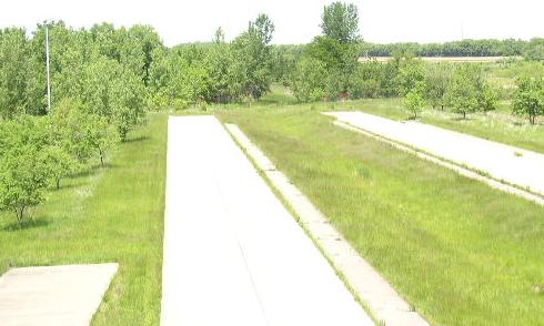
- Interstate 335 (I-335), a spur of I-35W, was proposed to connect I-35W with I-94 just north of downtown. The project got as far as right-of-way acquisition and grading for and paving of exit ramps at the east end on I-35W before it was cancelled due to local opposition. The southbound lanes of I-35W contain the vestiges of an entrance ramp from I-335 and a ramp to I-335 from the northbound lanes is visible despite having been demolished. Both are near the Hennepin Avenue overpass. (44°59′30″N 93°14′10″W / 44.991596°N 93.236026°W) North of this, the other half of the proposed full interchange is also visible. The exit from I-35W south to I-335 west is still graded and a stub of pavement that still exists was to be the ramp from I-335 east to I-35W north. (44°59′46″N 93°14′16″W / 44.996034°N 93.237888°W) A northbound exit from I-35W to Johnson Street makes a rather long dogleg that would have accommodated this ramp and the redundant Johnson Street exits support an I-335 merge. In the same area, a pavement stub existed in the I-35W median but has since been removed.[77]
- At the west end of the proposed I-335[77] there is pavement to support a wider ramp on the exit from eastbound I-94 to North 3rd Street. It was to be the ramp to eastbound I-335.[78] (44°59′28″N 93°17′03″W / 44.991239°N 93.284183°W)
- North St. Paul
- In the late 1950s, what is now Minnesota State Highway 5 (MN 5) was proposed to follow a more direct, part-freeway/part-arterial routing between downtown St. Paul and the existing four-lane segment along MN 5 east of MN 120. The northern MN 5/MN 120 junction includes some ramp grading for what was then planned as a folded diamond interchange, but cancelled along with the rest of the proposed highway sometime in the 1970s.[79] What was to be the eastbound off-ramp loop is now used as an access road to a Minnesota Department of Transportation staging area (44°59′51″N 92°59′08″W / 44.997468°N 92.985567°W)
- Monticello
- I-94 exit 195 for County Road 75 (CR 75), westbound only and the corresponding eastbound on-ramp were closed and replaced in 2006 by exit 194 (CR 18 and CR 39),[80] with ramps from the former exit 195 barricaded but still intact. (45°17′11″N 93°45′40″W / 45.286391°N 93.76123°W)
Mississippi
- Pearl
- Stub roadways exist at the intersection of Mississippi Highway 475 (MS 475) and Old Brandon Road near Jackson–Evers International Airport. The interchange may one day be completed if MS 475 is realigned in the area.
- Hattiesburg
- Right-of-way for a loop ramp and a collector-distributor roadway exists at the interchange of Interstate 59 (I-59) and U.S. Route 98 (US 98) at the southern edge of the city. (31°14′27″N 89°19′21″W / 31.240701°N 89.322583°W) US 98 may one day be extended west from the interchange to bypass the city.
- Vicksburg
- The railroad bridge that formerly carried US 80 across the Mississippi River is now closed to automobiles. There is also an abandoned toll house on the Mississippi side. (32°18′48″N 90°54′05″W / 32.313205°N 90.901517°W )
- Several highways were destroyed when the Tennessee–Tombigbee Waterway was built through east Mississippi. These roads were either bypassed with new spans or deemed too unimportant to bridge across the waterway. Sections of MS 364 (34°43′41″N 88°18′23″W / 34.728017°N 88.306485°W), MS 178 (34°16′22″N 88°25′36″W / 34.272842°N 88.426584°W), MS 182 (33°29′12″N 88°27′08″W / 33.486659°N 88.452269°W), and old alignments of US 45 and MS 50 (31°14′24″N 89°19′13″W / 31.239995°N 89.320157°W) are discontinuous at the waterway.
Missouri
- Bridgeton
- Prior to the Lambert-St. Louis International Airport runway expansion in the 2000s, Lindbergh Boulevard crossed over Natural Bridge Road in a diamond interchange. Both roadways were moved during the expansion. The overpass was destroyed, but two ramps remain in place with the former, four-lane Lindbergh Boulevard (this particular section is now named Banshee Drive) ending in a stub at the ends of the ramps, where they intersect with the old alignment of Natural Bridge Road, which remains but was renamed to Navaid Road.(38°45′12″N 90°23′18″W / 38.753426°N 90.388268°W) Additionally, during the construction of the runway, Lindbergh Boulevard was temporarily moved eastward north of Interstate 70. A portion of the temporary alignment still exists southeast of the Linbergh Boulevard/Natural Bridge Road interchange, complete with roadway markings and turn lanes and is used as a parking lot.(38°44′51″N 90°23′32″W / 38.747610°N 90.392307°W)
- Hillsboro
- Missouri Route 21 (Route 21) is a freeway for a portion of its length. The southern freeway portion ends in stubs at Missouri supplemental route B. (38°13′31″N 90°34′36″W / 38.225269°N 90.576782°W) There are plans to extend the freeway portion south of DeSoto.[81]
- Kansas City
- An abandoned on-ramp can be seen at Interstate 70 (I-70) and East Truman Road. The roadbed is still visible, and a bridge over East Truman Road remains unused. (39°05′40″N 94°32′38″W / 39.094464°N 94.543866°W)
- There used to be an on-ramp to westbound I-70 from Norton Avenue. It was removed after 1995,[82] eliminating a left-hand merge. (39°04′25″N 94°32′06″W / 39.073636°N 94.534907°W)
- Lexington
- There are stubs and grading of a missing freeway portion of Route 13 at U.S. Route 24 (US 24) to the continuation of Route 13 to the south.
- Pineville
- A ramp stub and flyover grading in US 71 and the south end of I-49 exist for the future Bella Vista Bypass .
- St. Louis
- A proposed Route 755 was to start at I-44 at its interchange with I-55 and connect to I-70, interchanging with I-64/US 40. The freeway would have looped to the west of downtown.[83] Indications of the cancelled freeway can be seen in old satellite images, showing a pavement stub on the Lafayette Avenue exit ramp that has since been removed. There is also blocked off lane on eastbound I-44 that would have been a ramp to northbound Route 755.[83] It was to follow Grattan Street, but since the freeway's cancellation, it and Grattan have mostly been replaced by Truman Parkway. Ramp stubs can also be seen around the exits for 20th, Chestnut, and Market Streets from I-64. (38°37′40″N 90°12′42″W / 38.627834°N 90.211744°W). A sufficiently large right of way is present there as well.
- Because of the construction of new Busch Stadium, the 8th Street on-ramp to eastbound I-64 was demolished,[84] leaving a ramp stub on the Interstate. It is not viewable from the air because of the elevated freeway design downtown, but can be seen while driving. It was a left-entry ramp. The old ramp design can still be seen on a Microsoft Research maps satellite image.[85]
- Spring Avenue once had a viaduct over a rail yard that connected Forest Park Avenue with Gratiot Street. The viaduct was closed and partially demolished sometime after 1991 (and perhaps even after 1998[86]). The south end is barricaded by a mound of gravel and the vegetation is overgrown. The north end is blocked by a fence, followed by semi trailers and jersey barriers. Between I-64 and where Scott Avenue would intersect Spring, the viaduct has been demolished and Spring exists as an at-grade street[87] off of Market Street. The remaining elevated roadway has been demolished. (38°37′46″N 90°14′18″W / 38.629519°N 90.238277°W)
- The MacArthur Bridge formerly carried traffic across the Mississippi River starting 1917, carrying US 66 and US 460 at times. Due to deterioration, the bridge was closed to automobile traffic in 1981, though trains still use the bridge today. Some of the connections were demolished, including the approach in Illinois,[88] though an unused bridge frame[89] and wide supports[90] still stand. Remnants of approaches are used as a parking lot on the west side[91] or are just shut off from traffic by jersey barriers[92] (Note that as of March 2012 the parking area was rebuilt and the remnant removed, the image herein has not been updated). Pavement still exists on the bridge, though only up to the Illinois side.[93]
- Sunset Hills
- The I-270/I-44 interchange used to be a full cloverleaf with collector-distributor ramps.[94] Two of the loops were replaced with flyovers; the eastbound I-44 ramp to northbound I-270 and the westbound I-44 ramp to southbound I-270. (38°32′54″N 90°25′37″W / 38.548199°N 90.427008°W) Grading for the demolished loop ramps is still visible from above.
- Hannibal
- I-72 once temporarily ended near Fall Creek, Illinois, just southeast of its interchange with I-172.[95] This was because of the substandard Mississippi River crossing that US 36 used to enter Missouri. Once the new Mark Twain Memorial Bridge was constructed north of the old bridge, I-72 and US 36 were designated on the new crossing, with I-72 ending at US 61. Route 79 took over the former US 36. While the former Mark Twain Memorial Bridge was destroyed, the approach is still visible. (39°42′49″N 91°21′33″W / 39.713583°N 91.359118°W)
- Arlington
- The alignment of I-44 was shifted north in 2005[96] to straighten out curves in the previous alignment. The previous alignment is clearly visible from the air and from Arlington Outer Road, a former outer road of the interstate. (37°56′03″N 91°57′07″W / 37.934179°N 91.95184°W)
- Branson
- Route 465 has plans to continue south from its current southern terminus at Route 76. Paved stubs continue south from the interchange and ramps to and from the south are partially paved and graded. (36°40′19″N 93°19′06″W / 36.671861°N 93.318222°W) The road is planned to connect back to US 65 south of Hollister.
Nebraska
- Omaha
- At the intersection of Interstate 480 (I-480) and U.S. Highway 75 (US-75) downtown, there were several bridges and ramps that would have connected to the West Expressway, but the West Expressway project was canceled. The interchange construction was finished in 2014 and unnecessary bridges and ramps were removed.
- The bridge over Glenn Cunningham Lake on Nebraska Highway 36 (N-36) can accommodate a divided highway, but as of 2013, only the southern half of the bridge is used. (41°21′52″N 96°03′28″W / 41.364538°N 96.057887°W)
- Dawes County
- An undivided portion of US-385 in western Nebraska has a parallel path for approximately 4 mi (6.4 km), which is graded, with some bridges constructed, but otherwise unpaved. It appears to be an old alignment. (42°33′23″N 102°58′11″W / 42.556423°N 102.969725°W)
- Box Butte County
- US-385 bypasses Berea to the east. North of an intersection with N-2 south of the city, US-385 curves around and over N-2, but the former alignment is still visible with some unused pavement now orphaned as a stub. (42°11′49″N 102°57′49″W / 42.197074°N 102.963599°W) This is probably a result of the rerouting of U.S. 385 in 2000.[97]
Nevada
- Carson City
- I-580 was recently extended from Mount Rose Highway/State Route 431 (SR 431) in Reno to the Carson City Bypass running east of the city center. There are plans to continue the freeway further south from its current terminus at Fairview Drive to US 50/US 395/South Carson Street.[98] The current southern terminus has a long, paved, southbound mainline stub and graded on-ramp from Fairview and a northbound off-ramp stub on Fairview. (39°09′00″N 119°44′42″W / 39.150065°N 119.745058°W)
- Enterprise
- In 2007, State Route 160 was realigned slightly over I-15 in southern Las Vegas. The highway was moved a short distance to the south between Valley View Boulevard and Las Vegas Boulevard, realigning the southeastern terminus with East Windmill Lane at the intersection of Las Vegas Boulevard. The old alignment formerly continued northeast and ended at Las Vegas Boulevard between East Robindale Road and East Moberly Avenue. Abandoned, marked pavement and exit ramps from the old alignment still exist, a billboard still stands alongside the old, unused highway. (36°02′47″N 115°10′38″W / 36.046254°N 115.177330°W)
- North Las Vegas
- The Las Vegas Beltway is a three-quarter beltway around the city. It is currently a freeway on the southern half and an expressway for most of the northern half. Construction is ongoing to upgrade the northern half to Interstate Highway standards to eventually extend the I-215 designation onto the Beltway. While some of the Beltway interchanges in the northern half are in interim form, some of the future exits have mainline stubs as traffic is shifted onto the future on- and off-ramps. Three examples are Losee Road (36°17′22″N 115°07′01″W / 36.289454°N 115.116926°W), North Pecos Road (36°17′23″N 115°05′54″W / 36.289627°N 115.098429°W), and North Lamb Boulevard. (36°17′24″N 115°04′48″W / 36.289912°N 115.079911°W)
New Jersey
Main article: List of unused highways in New Jersey
New York
Main article: List of unused highways in New York
North Carolina
Main article: List of unused highways in North Carolina
North Dakota
- Fargo
- The interchange of Interstate 94 (I-94) and Interstate 29 (I-29) was formerly a full cloverleaf interchange but has been modified. The southbound I-29 to eastbound I-94 ramp was removed and replaced with a flyover, sometime prior to 2005.[99] (46°50′47″N 96°50′32″W / 46.84627°N 96.842144°W)
Ohio
Main article: List of unused highways in Ohio
Oklahoma
- Tulsa
- A section of Interstate 44 (I-44) was bypassed when the Creek Turnpike was constructed, and I-44 was routed through a new interchange with the northern terminus of the turnpike.[100] The existing pavement is no longer used, and a city street (Pine Street) still crosses the abandoned highway on a bridge. (36°10′35″N 95°44′23″W / 36.176475°N 95.739841°W) I-44's interchange with Oklahoma State Highway 66 (SH-66) also shows signs of the former routing of I-44. There are pavement stubs and grading that indicated a different configuration.
- A ramp from eastbound I-44 to southbound U.S. Route 169 (US 169) was eliminated due to safety concerns as a result of the proximity of US 169's ramp to 21st Street. This occurred in 2003.[101]
- Muskogee
- South of city are the remnants of a service plaza to serve the Muskogee Turnpike that was never built. (35°40′44″N 95°18′25″W / 35.67879°N 95.306954°W)
Oregon
Main article: List of unused highways in Oregon
Pennsylvania
Main article: List of unused highways in Pennsylvania
Puerto Rico
- Arecibo
- On Puerto Rico Highway 22 (PR-22) east, there is an unpaved stub ramp before the main toll, because that was the old exit 64 ramp to PR-2 then was replaced with a new ramp after the toll .
- On PR-2, before the PR-10 intersection (coming from San Juan) in Arecibo River, there is an abandoned rural highway, but that was the PR-2 old alignment before the new bridges .
- Bayamón
- Duero Avenue, where it was supposed to connect to the PR-167, ends abruptly .
- Unpaved ramp exist north of PR-22. This ramp was an exit of PR-22. (18°25′21″N 66°09′15″W / 18.422575°N 66.154133°W)
- Canóvanas
- Route 66 was ended at PR-3, after the extension to Rio Grande, PR-66 was reroute south of The Outlet 66 Mall building a Trumpet interchange leaving a gradding stub in the former eastbound lanes and the former westbound lanes was converted to a westbound 2 to 1 lanes on-ramp to Route 66.
- Carolina
- On PR-66 or Route 66, there is an unused unpaved diamond interchange (exit 8) with PR-8857, whose ramps are overgrown with vegetation .
- Ponce
- On PR-10, between the PR-52 exits and the PR-14 exit, is an unused interchange, complete with overpass, whose ramps are overgrown with vegetation .
- Toa Baja
- PR-22 was ended on PR-866/PR-855 intersection before the Arecibo extension, after this extension, the former PR-22 was modified, leaving a graded ramp and small pavement stub on PR-22 eastbound on-ramp.
- San Juan
- West of the old Río Piedras State Penitentiary, the Americas Expressway (signed as PR-18) has a ramp stub at the interchange with PR-21 from PR-21 eastbound to PR-18 northbound, because it was removed by the construction of the reversible lanes ( and ), and south of the interchange, there is an unused overpass bridge .
Rhode Island
- North Kingstown
- The Rhode Island Route 138 (Route 138) expressway extends westward from its intersection with U.S. Route 1 (US 1). This was built for the second Interstate 895 (I-895) that was planned to bypass Providence. This second alignment was submitted for cancellation in December 1979,[102] which was approved in 1982.[103] (41°31′48″N 71°27′58″W / 41.530058°N 71.466086°W)
- Newport
- Just east of the Claiborne Pell Newport Bridge is a partially unused section of highway with stubs at both ends. The northern stub is part of the never built second alignment of I-895, while the southern stub would have been part of the southbound Route 238 connector into Newport.[102] (41°30′14″N 71°18′55″W / 41.503949°N 71.31526°W)
- Johnston
- I-86 was planned, in 1968, to connect Hartford and Providence. It was cancelled in 1982 because of the impending impact on the nearby Scituate Reservoir but there is an indication as to where it was to enter the Providence area. Exits 6A-B for US 6 on I-295 was where I-84 was planned to intersect the partial beltway, with stubs on the US 6 mainline and ramp and flyover grading indicating this. There is also a stub on US 6 to northbound I-295 for the unbuilt flyover. A ramp from I-295 north (exit 6B) that was to go to westbound I-84 has been converted into a turnaround ramp (I-295 north to I-295 south).[104][105] (41°49′15″N 71°30′46″W / 41.820775°N 71.512649°W)
- East Providence
- There are pavement stubs at either end of the Henderson Bridge and even grading past the eastern end of the highway. The US 44 Expressway[106] was intended to cross the bridge but Massachusetts never purchased the land on which to build the expressway.[107] (41°49′44″N 71°22′50″W / 41.828818°N 71.38062°W)
- Providence
- There is a stub on-ramp from Route 1A (Allens Avenue) north to I-95 north at exit 19. The ramp from Route 1A interfered with the hurricane barrier's west dike,[108] so it was demolished. The original ramp went over Route 1A's southbound lanes as seen in an old satellite image.[109](41°48′42″N 71°24′21″W / 41.811683°N 71.405897°W)
- There is a stub off ramp from I-195 westbound where exit 1 used to be. It used to carry traffic into the heart of the financial/court district in 2002.[110] As of November 2008, there were still signs posted for it. It is being used occasionally for staging of construction vehicles working on the new I-195/I-95 connection realignment project.
South Carolina
- Andrews
- A shift in the routing of South Carolina Highway 41 Business (SC 41 Business) during the construction of the U.S. Route 521 Bypass (US 521 Byp.) left an unused portion of roadway near the location of the current route. The signs signifying a sharper curve can still be seen. (33°26′02″N 79°34′01″W / 33.43402°N 79.567024°W)
- Charleston
- Ramp stubs exist where US 17 formerly connected to the southern end of Interstate 26 (I-26). The ramps connected to the John P. Grace Memorial Bridge and the Silas N. Pearman Bridge over the Cooper River. When the bridges were replaced by the Arthur Ravenel Jr. Bridge in 2005, the old roadways were demolished, and a new interchange was built north of the terminus of I-26. (32°47′47″N 79°56′33″W / 32.796519°N 79.942617°W) A bridge support, from the Pearman span, still remains near the East Bay Street northbound on-ramp. (32°48′01″N 79°56′07″W / 32.800255°N 79.935294°W)
- At the western terminus of I-526 (Mark Clark Expressway) (32°47′28″N 80°01′55″W / 32.791063°N 80.032056°W) and the western terminus of SC 30 (James Island Connector Expressway) (32°45′04″N 79°58′09″W / 32.751099°N 79.969109°W), there are stubs of grading and/or overpass. The two termini will be linked to form an extended I-526 (Mark Clark Expressway).
- Columbia
- The SC 277 (I. DeQuincey Newman Freeway) was originally planned to continue through downtown to I-126.[111][112][113] Following its completion as far as SC 16 (Sunset Drive), construction was put on hold due to neighborhood opposition along its proposed routing. The extension was eventually cancelled in the 1980s, and the Bull Street spur was completed in the 1990s, which was supposed to be just an exit. The part of the right-of-way already acquired by South Carolina Department of Transportation was returned to the city in 2001. (34°01′39″N 81°02′16″W / 34.027517°N 81.037881°W)
- Georgetown
- The former Lafayette Bridge can be found at 33°22′11″N 79°15′53″W / 33.369603°N 79.264812°W). When the new bridges were built in the 1960s, the old bridges were decommissioned. The Lafayette Bridge was left standing for use as a fishing pier. However, the roads that carried US 17 to the bridges can still be seen on all sides of the Black and PeeDee rivers.
- The stubs of the bridge that once carried US 17 (Frasier Street) across the Sampit River can be found at 33°21′25″N 79°17′40″W / 33.35708°N 79.294553°W)
- Myrtle Beach
- The southern terminus of SC 31 (Carolina Bays Parkway), at SC 544, has a graded area that extends past the cloverleaf interchange. This will become part of an extension to US 17 via SC 707 in Socastee. (33°42′02″N 79°00′53″W / 33.700529°N 79.014837°W) The northern terminus at SC 9, though it does not have a stub, will eventually be extended to the NC state line. The entire route could eventually become part of I-74.
- A strip of pavement used by the Myrtle Beach International Airport running between runways was originally the original alignment of U.S. Route 501 before the current highway was opened in the 1950s. The former alignment of U.S. 501 still exists west of the airport as Emory Road and Highway 15 to the east. 33°41′18″N 78°55′39″W / 33.688271°N 78.927388°W)
- A piece of stub grading which was once a road that connected US 17 to the Myrtle Beach International Airport can be found at 33°42′05″N 78°55′58″W / 33.701285°N 78.932838°W. The road was removed during the construction of the Coastal Grand Mall and is now used as a barrier between two retention ponds.
- Santee
- The US 15/US 301 bridge over Lake Marion is closed to traffic because of unstable foundations and is now used as a fishing pier. It also forms a piece of the Palmetto Trail. (33°30′05″N 80°27′31″W / 33.501478°N 80.458682°W)
South Dakota
- Rapid City
- There used to be an exit 66 on Interstate 90 (I-90) east of Rapid City for Box Elder and the Ellsworth Air Force Base. This exit was closed on October 1, 2003, and the pavement ripped up. A new interchange (exit 67) opened a few months earlier that supplanted it. This exit is for Liberty Boulevard, which leads right to the gates of the Air Force Base. Local officials feared the potential closing of the base and successfully lobbied the state and federal government to construct a new interchange. The exit change will also help keep commercial development away from the runways.[114][115] While the pavement is gone, one can see grading outlining the old ramps. (44°07′04″N 103°04′11″W / 44.117832°N 103.069739°W)
Tennessee
- Knoxville
- At the southern end of Tennessee State Route 71 (SR-71; James White Parkway). The parkway was planned[116] to extend to connect to U.S. Route 441 (US-441; Chapman Highway) somewhere in the vicinity of Gov. John Sevier Highway. In late August 2013, the project was officially cancelled.[117] The parkway now terminates at Sevierville Pike. All traffic enters or leaves the parkway north of Sevierville Pike, but the bridge over the parkway has been completed, and the mainline extends under the bridge, terminating abruptly. (35°56′40″N 83°53′44″W / 35.944512°N 83.895571°W)
- Memphis
- Three pavement stubs exist as a result of a cancelled freeway on the north side of the city. One stub exists just after the Hernando de Soto Bridge off the elevated ramp from eastbound I-40 to Riverside Drive/Front Street. The ramp may not be visible to drivers, as jersey barriers block it off; however, the unfinished ramp is visible from ground level. (35°09′10″N 90°03′14″W / 35.152681°N 90.053928°W) On the Jackson Avenue to westbound I-40 on-ramp is another ramp stub. (35°09′15″N 90°03′10″W / 35.154126°N 90.052845°W) This, along with the above ramp stub, was to connect to a proposed freeway that ran north from this interchange along Mud Island to the SR-300 and US-51 (Thomas Street) interchange, where there is also ramp stub.[118] (35°11′57″N 90°01′57″W / 35.199079°N 90.032562°W) This is also the site where future I-69 will enter Memphis.[119]
- Ramp stubs once existed on Riverside Drive when there was not an open eastbound on-ramp for I-40 until The Pyramid's construction.
- I-40 was planned to go through the city's Overton Park, but public opposition, combined with a court victory by opponents, forced abandonment of the plans. The eastern portion of the road had already been built inside the I-240 loop; the extant highway is in use and is now named Sam Cooper Boulevard (with no route number assigned to it), while the northern portion of the I-240 loop was redesignated as I-40.[120] (35°08′57″N 90°01′13″W / 35.1493°N 90.0204°W)
- A stub ramp exists at the I-40/I-240 interchange in East Memphis. It will eventually allow for a two-lane flyover for I-40 westbound to continue through the interchange, relieving the current one-lane ramp of the increased traffic in the region. A corresponding flyover in the eastbound direction will also be built (this will be the fourth level of the interchange) and replace the existing one-lane ramp.[121] In addition, grading remains as the remnant from a loop ramp from westbound I-40 to westbound I-240 which was destroyed after a two-lane flyover replaced it.
- At the intersection of I-55 and US-51 (Elvis Presley Boulevard), a loop ramp has been eliminated. The ramp ran from northbound I-55 to southbound US-51 and was eliminated during the widening of I-55 in 2001 due to weaving conflicts with an on-ramp from Brooks Road immediately before the loop. (35°03′50″N 90°01′24″W / 35.064024°N 90.0234°W)
- Similarly, a loop ramp from northbound I-55 to westbound SR-17/Shelby Drive was eliminated as part of the widening.
- Nashville
- There is a freeway stub at the western end of Interstate 840. The high costs of going through hilly land and the recession have put the plan for a northern loop on hold,[122] but it might be, in the future, designated "I-840." An entire loop would be about 178 mi (286 km) long.
- Cumberland Gap
- The Cumberland Gap Tunnel replaced the two-lane US-25E over the Cumberland Gap to allow four lanes of traffic to travel the route. The existing road was closed except for a short section used by the National Park Service. The pavement was recently removed for more of a historic look.[59] (36°36′12″N 83°40′14″W / 36.603402°N 83.670588°W)
- Shelby Forest
- SR-388 ends abruptly in a stub at Locke-Cuba Road. (35°19′57″N 90°00′56″W / 35.332414°N 90.01544°W)
- Rockford
- SR-162 (Pellissippi Parkway) ends at SR-33 (Old Knoxville Highway). It is planned to extend further south to US-321 (Lamar Alexander Parkway).[123] (35°48′24″N 83°56′26″W / 35.806633°N 83.940559°W)
Texas
Main article: List of unused highways in Texas
Vermont
- Burlington
- At the west end of Interstate 189 (I-189) at U.S. Route 7 (US 7), there are some ramp stubs and about a 0.5-mile-long (0.80 km) unused highway west of that interchange. There are plans for this to be part of a boulevard into downtown Burlington.[124](44°26′52″N 73°12′30″W / 44.447905°N 73.208427°W)
- Bennington
- There is a very unusual incomplete fused double trumpet interchange for the US 7 and Vermont Route 279 (VT 279) interchange. VT 279 was extended, east and west to VT 9, there were stubs and grading to suggest its planned configuration. The construction configuration, however, was slightly different, which left a pavement stub within the interchange. (42°54′14″N 73°12′06″W / 42.903791°N 73.201647°W)
- Essex Junction
- On both the north and south ends of VT 289, there are stubs that indicate an extension of the highway. Original plans had it intersect with I-89 near Williston to the south, and with I-89 near Colchester to the north, to complete an auxiliary highway. VT 289 also appears to have an unfinished jughandle that is partially paved and graded and leads to what appears to be a soccer field. (44°29′35″N 73°03′53″W / 44.492947°N 73.06464°W)
- Fair Haven
- On US 4 at the New York state line, there is grading for a trumpet interchange with VT 4A. Because US 4 is a two-lane road in New York, the freeway in Vermont ends there, and VT 4A has an ordinary intersection with US 4. (43°35′24″N 73°17′17″W / 43.589973°N 73.2881°W)
- Guilford
- There is a short roadway that once connected I-91 to US 5 before the section in Massachusetts was completed. (42°43′51″N 72°34′18″W / 42.730859°N 72.571542°W)
Virginia
Main article: List of unused highways in Virginia
Washington
Main article: List of unused highways in Washington
West Virginia
Main article: List of unused highways in West Virginia
Wisconsin
- Milwaukee
- The proposed Stadium Freeway was to have a southern terminus at I-43/I-894 in southern Milwaukee. While the freeway was never built south of National Ave, a graded ramp exists just east of W. Loomis Rd. The ramp was to come from I-43/I-894 eastbound going north. It was a complete interchange, but one ramp was demolished[125] (it appears it was a flyover as the top level) and there is a hint of a left-exit ramp just west of the proposed interchange. Other ramps exist at this unusually wide interchange and lead to and from a park and ride lot. In 2011 the lower half of the park & ride and all exit ramps were shut off to public traffic and were made available to highway construction traffic only (for the I-94 North–South Freeway Project). With the closing of the west-bound I-94 off-ramp towards the park & Ride, a new off-ramp was constructed that leads to Loomis Road northbound. This required the removal of the on-ramp from the park & ride headed towards east-bound I-94. (42°57′45″N 87°57′48″W / 42.962382°N 87.963227°W)
- U.S. Route 41 (US 41; Stadium Freeway in this section) was not completed to its planned northern terminus either. It ends at Lisbon Road with a wide median and pavement stubs. (43°03′31″N 87°58′16″W / 43.058698°N 87.971027°W) It was to meet the proposed and planned Park Freeway West in this area and travel northwest for about 1 mile (1.6 km) and head north, intersecting the Bay and Fond du Lac freeways on its proposed alignment to I-43 (North–South Freeway) in Ozaukee County, where it would end. The extension north of Lisbon Road was cancelled in 1974.[125]
- Because a part of the Lake Freeway was canceled after it was planned,[126] extra pavement that was built in anticipation of the northerly continuation, named the "Downtown Loop Closure," sits unused. In one form, it is a ramp stub that was to carry the northbound lanes, and in another, it is a wide bridge that carries less traffic (than originally intended) from Lincoln Memorial Drive to southbound I-794.[125] (43°02′05″N 87°54′00″W / 43.034819°N 87.899884°W)
- Elkhorn
- US 12 abruptly ends at Wisconsin Highway 67 (WIS 67) just north of the city. Northbound lanes must exit and the mainline continues for about 50 yards (46 m). Southbound lanes actually utilize an underpass that was built to carry US 12 northwest toward Whitewater. More unused pavement exists as a never completed on-ramp from southbound US 12 to WIS 67 and an on-ramp (broken up by the operational "flyunder" ramp) from WIS 67 to northbound US 12. Grading is evident on the west side of the interchange. The unbuilt expressway was to be part of a Madison to Chicago route that was limited by Illinois' participation.[127] (42°41′54″N 88°32′28″W / 42.698349°N 88.541243°W)
- Genoa City
- The southern terminus of the Interstate-quality US 12 ends just east of the city. Southbound lanes exit onto a ramp with an interchange with WIS 120. Northbound lanes merge onto a stub just before a Welcome to Wisconsin rest area. US 12 was to be a part of a fully controlled access freeway from Madison to Chicago, with a connection to the Illinois Tollway System at the state line.[127] There is grading south of the interchange as well. (42°29′53″N 88°18′56″W / 42.498159°N 88.315423°W)
- Wausau
- WIS 29 interchanges with I-39/US 51 south of the city and had a westbound stub as the highway transitioned into a loop ramp to southbound I-39/US 51. The interchange has since been upgraded.[128] (44°53′48″N 89°38′22″W / 44.896741°N 89.639511°W)
- Neenah
- There are a couple of ramp stubs on the ramp from eastbound US 10 to southbound US 41 at the US 10/US 41/WSI 441 interchange. They appear to lead to yet-unbuilt flyovers for future expansion at the interchange.[129] One also exists on the US 41 southbound to US 10 westbound and some grading can be seen from above from the interchange's former configuration. (44°13′02″N 88°28′19″W / 44.217309°N 88.471828°W)
- Tomahawk
- North of the city, at the Lincoln–Oneida county line, US 51 loses its freeway status and continues north as a two-lane highway. (45°33′39″N 89°40′18″W / 45.560789°N 89.671619°W) After a lane drop approaching the end of the freeway, the northbound travel lane is shunted through the median while a northbound pavement stub exists before dying in the grass, indicating a possible extension north, however there are no plans to do so in the near future.
See also
References
- ↑ See:
- Office of Emergency Management (June 20, 2005). "US&R and NY-TF1 Practice for the Real Thing" (Press release). City of New York. Archived from the original on October 14, 2006. Retrieved January 15, 2007.
- Barrie (City) v. 1606533 Ontario Inc. 2005 ONSC 24746, Superior Court of Justice (Ontario, Canada)
- Staff (1998). "H.R. 0686". Iowa House of Representatives. House File 686. 77th General Assembly.
- Petition Response Section, Exposure Investigation and Consultation Branch, Division of Health Assessment and Consultation, Agency for Toxic Substances and Disease Registry (November 17, 1999). Petitioned Public Health Assessment (Report). New York City: Centers for Disease Control. Retrieved January 15, 2007.
- "Land Title Amendment Act, 1993". Official Report of Debates of the Legislative Assembly (Hansard). 12 (13): 9010–17. July 21, 1993.
- Munroe, Tapan (January 1999). "Trends Analysis for Parks & Recreation: 2000 and Beyond" (PDF). California Park & Recreation Society. Retrieved January 15, 2007.
- "Chapter 5: Detailed Comparison of Alternatives—Seattle" (PDF). SR 520 Bridge Replacement and HOV Project. Washington Department of Transportation. May 2, 2005. Retrieved January 15, 2007.
- Anderson, Steve. "CT 11 Expressway". New York City Roads. Self-published. Retrieved January 15, 2007.
- ↑ See:
- Leasing of Closed Highways Regulation, Alta. Reg. 36/1986. January 15, 2007.
- R. v. Sanders 2004 NBPC 12, Provincial Court (New Brunswick, Canada)
- Highway Closings, R.R.O. 1990 599. January 15, 2007.
- ↑ Public Transportation and Rail Division (October 2006). "Expansion of King Street Station Tracks to Accommodate More Trains" (PDF). Public Transportation and Rail Division Monthly News. Washington State Department of Transportation: 4. Archived from the original (PDF) on October 8, 2006. Retrieved December 28, 2006.
- 1 2 "Kentucky Model Access Management Ordinance" (PDF). Kentucky Transportation Cabinet. October 2004. Retrieved January 15, 2007.
- ↑ Sommer, Dick (2005). "Ten Ways to Manage Roadway Access in Your Community" (PDF). Ohio Department of Transportation. Retrieved January 15, 2007.
- ↑ Bauserman, Christian E. (May 18, 1998). "Delaware County Engineer's Design, Construction & Surveying Standards" (PDF). Ohio Department of Transportation. Retrieved January 15, 2007.
- ↑ Geiger, Gene (Fall 1999). "Ohio DOT Constructs I-670 over a Water Treatment Sludge Lagoon in Columbus" (PDF). Ohio LTAP Quarterly. Ohio Department of Transportation. 15 (3): 1, 4. Archived from the original (PDF) on March 26, 2003.
- ↑ "Special Business Meeting Minutes". City of Union, Kentucky. June 23, 2006. Retrieved January 15, 2007.
- ↑ MacDonald, Ginny (April 14, 2000). "Warning: Sinkholes Ahead". The Birmingham News.
- ↑ "Alabama U.S. Highway 11". AARoads. Self-published.
- ↑ "I-759 Alabama". kurumi.com. Self-published.
- ↑ "Alabama Interstate 759". AARoads. Self-published.
- ↑ Beyerle, Dana (December 17, 2006). "Changes in bypass route requested". The Tuscaloosa News. Retrieved January 15, 2007.
- ↑ "Alabama Fantasy Freeways". ajfroggie.com. Self-published.
- ↑ "Montgomery Outer Loop". Alabama Department of Transportation. Retrieved February 7, 2014.
- ↑ http://www.governorpress.alabama.gov/pr/co-2006-05-24-transportation.asp
- ↑ "Sky Harbor Expressway (Decommissioned)". AARoads. Self-published. Retrieved April 4, 2013.
- ↑ "Phoenix: the Valley of the Sun". AARoads. Self-published. Retrieved April 4, 2013.
- ↑ Hofheimer, John. "Tolls could finance last leg of North Belt". Arkansas Leader.
- ↑ http://www.metroplan.org/files/53/2014-05AHTD_NB_Toll_Feasibility_Final.pdf
- ↑ Cox, Steve. "Harlahan Bridge". Self-published.
- ↑ "SR 141, Centre Road, Kirkwood Highway to Faulkland Road". Delaware Department of Transportation.
- ↑ Alpert, Steve. "Old US 13". Alps Roads. Self-published.
- ↑ Anderson, Steve. "Anacostia Freeway". DC Roads. Self-published.
- 1 2 Kozel, Scott. "Washington D.C. Interstates and Freeways". Roads to the Future. Self-published.
- ↑ Sanders, Reggie; Phipps-Evans, Michelle (December 22, 2014). "Southeast Boulevard Reopens Between 11th Street and Pennsylvania Avenue, SE (Barney Circle) on December 22" (Press release). District Department of Transportation. Retrieved June 10, 2015.
- ↑ "Georgia 166 - Langford Parkway (Planned Interstate 420)". AA Roads.
- ↑ Google (April 18, 2016). "Google Maps" (Map). Google Maps. Google. Retrieved April 18, 2016.
- ↑ "Hartsfield Atlanta International Airport 1961-1980". Archived from the original on 2008-02-14.
- ↑ Google (April 18, 2016). "Google Maps" (Map). Google Maps. Google. Retrieved April 18, 2016.
- ↑ Google (April 18, 2016). "Google Maps" (Map). Google Maps. Google. Retrieved April 18, 2016.
- ↑ Google (April 18, 2016). "Google Maps" (Map). Google Maps. Google. Retrieved April 18, 2016.
- ↑ Google (April 18, 2016). "Google Maps" (Map). Google Maps. Google. Retrieved April 18, 2016.
- ↑ Google (April 18, 2016). "Google Maps" (Map). Google Maps. Google. Retrieved April 18, 2016.
- ↑ Google (April 18, 2016). "Google Maps" (Map). Google Maps. Google. Retrieved April 18, 2016.
- ↑ "Interstate 185". AARoads.com.
- ↑ Burmaster, Bill. "Interstate 72, Illinois". Roads of the Mid-South & West.
- ↑ "Cancelled US 460 Freeway Through East St. Louis". Revive 755.
- ↑ Burmaster, Bill. "Illinois State Route 6". Roads of the Mid-South & West.
- ↑ "Illinois Route 29 Study". Illinois Department of Transportation.
- ↑ "Illinois 336: Peoria to Macomb Study". Illinois Department of Transportation.
- ↑ "Peoria, Illinois, United States 4/12/1998". TerraServerUSA.
- ↑ "Peoria Journal Star BridgeCam".
- ↑ Boudreu, Charleen. "The eastbound approach to the McClugage Bridge". U.S. Department of Transportation, Federal Highway Administration and Illinois Department of Transportation.
- ↑ "RATS Resolution 2006-3" (PDF).
- ↑ Carlson, Rich. "Illinois Highways Page".
- ↑ Burmaster, Bill. "Interstate 172". roads.billburmaster.com/.
- 1 2 "National, State Officials Break Ground on KY 841/US 42 Ramp Relocation" (Press release). The Ohio River Bridges. Retrieved December 28, 2006.
- 1 2 "Cable Relocation Marks Beginning of Work on KY 841 Off-Ramp Realignment" (Press release). The Ohio River Bridges. Retrieved December 28, 2006.
- ↑ O'Malley, Chris. "Indy rapid-transit plans gain speed, but drivers might not give up keys". Indiana Economic Digest.
- ↑ Finley, Gabrielle (August 13, 2003). "Accidents on new Greenbelt link a concern". The Courier-Journal. Louisville, KY.
- ↑ Sheldon, Shafer (July 13, 2000). "Greenbelt Highway: Many eager for road's completion". The Courier-Journal. Louisville, KY.
- ↑ Pike, Bill (August 30, 2000). "Greenbelt's last stretch opens to praise". The Courier-Journal. Louisville, KY.
- ↑ Mecklenborg, Jake (November 2004). "Interstate 471". Cincinnati-Transit.net. Self-published. Retrieved December 28, 2006.
- ↑ Campbell, Tracy. Interstate Highway System in Kentucky. Kentucky Transportation Cabinet, Department of Highways.
- ↑ Carlyle, Jeffrey. "Wendell H. Ford Western Kentucky Parkway". Kentucky Roads. Self-published.
- ↑ "Microsoft Research - Turning ideas into reality".
- ↑ "Bing".
- 1 2 Droz, Robert. "Old US 25E : Crossing the Cumberland Gap". Self-published. Archived from the original on September 27, 2007.
- 1 2 "Interstate 220 Louisiana". AARoads.
- ↑ "I-49 extension would result in relocations". The Advocate.
- ↑ "Interstate 49 Northbound (Shreveport Vicinity)". AARoads.
- ↑ "Interstate 49". AARoads. Self-published.
- ↑
- ↑ "Interstate 10 Eastbound (New Orleans to Mississippi)". AARoads. Self-published.
- ↑ "Louisiana 3139". Southeast Roads. Self-published.
- ↑ "New Orleans". Southeast Roads. Self-published.
- ↑ "The Second Battle of New Orleans: Vieux Carré Riverfront Expressway (I-310)". Federal Highway Administration.
- ↑ "Interstate 410". kurumi.com. Self-published.
- ↑ "U.S. Highway 90 Louisiana, Eastbound". Southeast Roads. Self-published.
- ↑ 4 km N of Biddeford, Maine, United States (Map). Cartography by USGS. July 1, 1988.
- ↑ 4 km W of Gardiner, Maine, United States (Map). Cartography by USGS. United States Geological Survey. July 1, 1991.
- ↑ Staff. "US 31 Connection to I-94 Study". Michigan Department of Transportation.
- ↑ "NETR Online • Historic Aerials". Historic Aerials.
- ↑ Bessert, Christopher J. "Annotated Satellite Photo of the US 12 and M-52 Intersection". Michigan Highways. Self-published. Retrieved July 9, 2012.
- ↑ Bessert, Christopher J. (December 15, 2011). "Historic US 112". Michigan Highways. Self-published. Retrieved July 9, 2012.
- 1 2 "I-335 Minneapolis North Loop". ajfroggie.com. Self-published.
- ↑ "I-335 Minneapolis North Loop". ajfroggie.com. Self-published.
- ↑ Scott, Steve. "Many Pitches for State Land". Saint Paul Pioneer Press.
- ↑ "New Interstate 94/Wright County Highway 18 interchange to open in Monticello" (Press release). Minnesota Department of Transportation. August 25, 2006.
- ↑ "Route 21 Corridor Projects" (PDF). Missouri Department of Transportation.
- ↑ Kansas City, Missouri, United States (Map). United States Geological Survey. July 1, 1995.
- 1 2 "Interstate 44". Interstate Guide at AARoads. Self-published.
- ↑ "MoDOT to Hold Public Hearing on Design of New 8th Street Ramp". St. Louis Front Page.
- ↑ "Microsoft Research - Turning ideas into reality".
- ↑ this satellite image
- ↑ Zavist, Jim. "Spring in Summertime". Urban Review STL.
- ↑
- ↑
- ↑
- ↑
- ↑
- ↑
- ↑ "Microsoft Research - Turning ideas into reality - Microsoft Research".
- ↑ Burmaster, Bill. "Interstate 172". roads.billburmaster.com/. Self-published.
- ↑ "Traffic Switches on I-44 in Phelps County" (Press release). Missouri Department of Transportation. Archived from the original on January 27, 2006. Retrieved April 9, 2013.
- ↑ Whidden, Jesse. "Nebraska US Highways 275–385". Nebraska Roads. Self-published.
- ↑ "Carson City Freeway Project". Nevada Department of Transportation. Retrieved February 20, 2014.
- ↑ . Historic Aerials http://www.historicaerials.com/aerials.php?scale=2.46907589953053E-05&lat=46.8492498493847&lon=-96.8403694120408&year=2005. Retrieved October 10, 2014. Missing or empty
|title=(help) - ↑ McMahon, Martin. "Oklahoma Terminus: Creek Turnpike". Roadklahoma.
- ↑ Stuve, Eric. "Interstate 44". OK Highways. Self-published.
- 1 2 Anderson, Steve. "Interstate 895-Rhode Island (unbuilt)". Boston Roads. Self-published.
- ↑ "I-895 (cancelled) Rhode Island; Massachusetts". kurumi.com. Self-published.
- ↑ Anderson, Steve. "Dennis J Roberts Expressway (US 6)". Boston Roads. Self-published.
- ↑ Anderson, Steve. "Interstate 295-Rhode Island". Boston Roads. Self-published.
- ↑ Anderson, Steve. "Unbuild Roads in Rhode Island". Boston Roads. Self-published.
- ↑ Anderson, Steve. "US 44 Expressway-Massachusetts". Boston Roads. Self-published.
- ↑ "Fox Point Hurricane Barrier". Providenceri.com.
- ↑ "Microsoft Research - Turning ideas into reality".
- ↑ "terraserverusa - Bing".
- ↑ "Interstate 126". Southeastroads.com.
- ↑ "Interstate 20". Southeastroads.com.
- ↑ "Interstate Business Route 26". Interstate-Guide.com.
- ↑ "Exit 66 now road to nowhere". Rapid City Journal. October 2, 2003.
- ↑ "Interstate 90". Interstate Guide at AARoads. Self-published.
- ↑ "TDOT Announces Decision on James White Parkway Extension" (Press release). Tennessee Department of Transportation. October 13, 2005. Archived from the original on May 19, 2011.
- ↑ "TDOT Commissioner Makes Statement on the James White Parkway Extension Project" (Press release). Tennessee Department of Transportation. August 28, 2013.
- ↑ Lawrence, Chris. "Tennessee Highway 300". LordSutch.com. Self-published.
- ↑ Lawrence, Chris. "I-69 Metropolitan Memphis Routing". I69Info.com. Self-published.
- ↑ Gulyas, Sandor. "Memphis Highways". Roadfan. Self-published.
- ↑ "I-40/I-240 Interchange Reconstruction". Tennessee Department of Transportation.
- ↑ "TDOT Announces Decision on State Route 840 North" (PDF) (Press release). Tennessee Department of Transportation. October 31, 2003. Retrieved July 17, 2007.
- ↑ "Interstate 140". Southeast Roads. Self-published.
- ↑ Welch, Victoria (December 1, 2006). "Residents frustrated over Champlain Parkway". The Burlington Free Press.
- 1 2 3 Bessert, Christopher. "Milwaukee Freeways". Wisconsin Highways. Self-published.
- ↑ Bessert, Christopher. "Milwaukee Freeways". Wisconsin Highways. Self-published.
- 1 2 Bessert, Christopher. "Highways 10 through 19". Wisconsin Highways. Self-published.
- ↑ Staff. "US 51/WIS 29 Project". Wisconsin Department of Transportation. Retrieved December 1, 2008.
- ↑ Staff (March 14, 2006). "US 10/WIS 441 Expansion Need". Wisconsin Department of Transportation. Retrieved August 9, 2011.
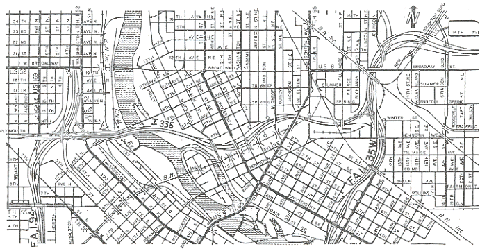
External links
| Wikimedia Commons has media related to Abandoned roads in the United States. |
- Unsung Monuments in "The Monument City" – photographic essay of Baltimore area stubs (archived)
This article is issued from Wikipedia - version of the 11/29/2016. The text is available under the Creative Commons Attribution/Share Alike but additional terms may apply for the media files.