Colchester, Vermont
| Colchester, Vermont | |
|---|---|
| Town | |
|
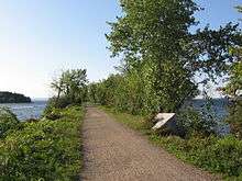
View of Malletts Bay (part of Lake Champlain) from Bayside Park near the center of Colchester | |
 Location in Chittenden County and the state of Vermont | |
 Colchester, Vermont Location in the United States | |
| Coordinates: 44°32′31″N 73°11′48″W / 44.54194°N 73.19667°WCoordinates: 44°32′31″N 73°11′48″W / 44.54194°N 73.19667°W | |
| Country | United States |
| State | Vermont |
| County | Chittenden |
| Area | |
| • Total | 58.6 sq mi (151.7 km2) |
| • Land | 36.3 sq mi (94.1 km2) |
| • Water | 22.2 sq mi (57.6 km2) |
| Elevation | 95 ft (29 m) |
| Population (2010) | |
| • Total | 17,067 |
| • Density | 470/sq mi (181.4/km2) |
| Time zone | Eastern (EST) (UTC-5) |
| • Summer (DST) | EDT (UTC-4) |
| ZIP codes | 05439, 05446, 05449 |
| Area code(s) | 802 |
| FIPS code | 50-14875[1] |
| GNIS feature ID | 1462073[2] |
| Website |
www |

Colchester is a town in Chittenden County, Vermont, United States. The population was 17,067 as of the 2010 census.[3] It is the fourth-most populous municipality and second-most populous town in the state of Vermont by population.[4] Colchester is a suburb of the city of Burlington, Vermont's most populous municipality. The town is directly to Burlington's north on the eastern shore of Lake Champlain to the west of the Green Mountains. The Vermont National Guard is based in the town, and it is also home to the campus of Saint Michael's College.
Geography
Colchester is located on the shore of Malletts Bay, part of Lake Champlain. The westernmost part of the town touches the New York state border in the middle of the lake. To the northwest across the eastern arm of the lake lies the town of South Hero in Grand Isle County, Vermont. Chittenden County communities bordering Colchester are Milton to the northeast, Westford touching the easternmost point of Colchester, Essex to the southeast, and the cities of South Burlington, Winooski, and Burlington to the south.
According to the United States Census Bureau, Colchester has a total area of 58.6 square miles (151.7 km2), of which 36.3 square miles (94.1 km2) is land and 22.2 square miles (57.6 km2), or 38.0%, is water.[3]
History
About 2,000 years ago, during the Early Woodland period, pre-Columbian natives lived in the area.[5] Chartered June 7, 1763,[6] the town was named for the Earl of Colchester.[7]
In 1922, the area of Winooski broke away from the town and formed its own city.
Demographics
| Historical population | |||
|---|---|---|---|
| Census | Pop. | %± | |
| 1790 | 137 | — | |
| 1800 | 347 | 153.3% | |
| 1810 | 657 | 89.3% | |
| 1820 | 960 | 46.1% | |
| 1830 | 1,489 | 55.1% | |
| 1840 | 1,739 | 16.8% | |
| 1850 | 2,575 | 48.1% | |
| 1860 | 3,041 | 18.1% | |
| 1870 | 3,911 | 28.6% | |
| 1880 | 4,421 | 13.0% | |
| 1890 | 5,143 | 16.3% | |
| 1900 | 5,352 | 4.1% | |
| 1910 | 6,450 | 20.5% | |
| 1920 | 6,627 | 2.7% | |
| 1930 | 2,638 | −60.2% | |
| 1940 | 3,031 | 14.9% | |
| 1950 | 3,897 | 28.6% | |
| 1960 | 4,718 | 21.1% | |
| 1970 | 8,776 | 86.0% | |
| 1980 | 12,629 | 43.9% | |
| 1990 | 14,731 | 16.6% | |
| 2000 | 16,986 | 15.3% | |
| 2010 | 17,067 | 0.5% | |
| Est. 2014 | 17,384 | [8] | 1.9% |
| U.S. Decennial Census[9] | |||
As of the census[1] of 2000, there were 16,986 people, 6,144 households, and 4,184 families residing in the town. The population density was 460.5 people per square mile (177.8/km2). There were 6,727 housing units at an average density of 182.4 per square mile (70.4/km2). The racial makeup of the town was 96.53% White, 0.63% African American, 0.17% Native American, 1.58% Asian, 0.04% Pacific Islander, 0.25% from other races, and 0.80% from two or more races. 1.11% of the population were Hispanic or Latino of any race.
There were 6,144 households out of which 34.1% had children under the age of 18 living with them, 55.2% were married couples living together, 8.8% had a female householder with no husband present, and 31.9% were non-families. 22.2% of all households were made up of individuals and 5.0% had someone living alone who was 65 years of age or older. The average household size was 2.50 and the average family size was 2.96.
In the town the population was spread out with 22.6% under the age of 18, 16.2% from 18 to 24, 32.1% from 25 to 44, 22.7% from 45 to 64, and 6.4% who were 65 years of age or older. The median age was 33 years. For every 100 females there were 96.0 males. For every 100 females age 18 and over, there were 95.0 males.
Economy
One measure of economic activity is retail sales. Colchester was fourth in the state in 2007 with $245.8 million.[10] Major employers in the town include the VNA of Chittenden & Grand Isle Counties, Saint Michael's College, Costco Wholesale Corporation, Green Mountain Power, Shaw's Supermarket, and Champlain Cable Corporation. [11]
In 2015, the town of Colchester made Fortune Magazine's list of "100 Best Places to Live" (ranked #100), along with Launch a Business and Money Magazine's list of "50 Best Places to Live" (ranked #40). [12]
Personal income
In 2014, the median household income for Colchester was $68,440; the per capita income was $30,877. Males had a median income of $38,268 versus $30,880 for females. About 5.4% of families, 8.2% of those under age 18, and 9.7% of those age 65 or over (total of 10.6% of the population) were below the poverty line. In 2011, the median home value was $246,269.[13]
Tourism
There has been an annual "Lake Champlain International Father's Day Fishing Derby" (LCI) since 1981. In 2009, 6,000 fishermen entered.[14]
The lakeshore areas of Colchester get an influx of vacationers every summer from southern New England and the New York City area. Traffic, especially around the Fourth of July holiday, increases by a substantial margin.
Niquette Bay State Park offers hiking and swimming in Lake Champlain.
Government
Public safety
In 2008, property crimes increased by 36.9%. Overall, the number of crimes rose 28.9% to 1,486 incidents.[15]
Transportation
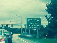
Interstate 89 passes through the area, with exits 16 and 17 serving Colchester. Exit 16 connects to the concurrency of US Routes 2 and 7 (Roosevelt Highway), just north of Winooski. Exit 17 connects to US 2, which goes west to the Champlain Islands, and also to US 7, which heads north toward the town of Milton.[16]
In the southeastern part of Colchester, and also along the US Route 7 corridor, bus service is provided by Chittenden County Transportation Authority.[17]
Notable people
- Alfred Elisha Ames, physician and politician
- Tom Brennan, men's basketball coach at the University of Vermont
- Ray Collins, pitcher with the Boston Red Sox (1909–1915)
- Roger Enos, Major General and commander of the Vermont Militia in the later stages of the American Revolution
- Donato Giancola, science fiction and fantasy illustrator
- Richard Tarrant, American businessman and politician
- Lucy Wheelock, Founder and First President of Wheelock College and Early Childhood pioneer
Education
- Saint Michael's College is located here.
- Albany College of Pharmacy and Health Sciences- Vermont Campus, the first pharmacy school in Vermont, is located here on Water Tower Hill.
Public school system
Around 2,200 children attend the five schools in Colchester's school district. The district consists of one high school, Colchester HS, one middle school, Colchester Middle School, an elementary school Malletts Bay School, and two young schools Porters Point School and Union Memorial School.
Colchester High School is home to the award-winning Colchester Theatre Company.
The Colchester School District underwent a teacher strike during October, 2005. The strike began over pay increases but quickly escalated to include many other aspects of the system. The strike ended on October 23, 2005, with an agreement on pay between teachers and board, and school re-opened on Monday the 24th. Negotiations took place for around five hours on October 18, 2005, but resulted in no settlement, and again on the 23rd, resulting in the conclusion to the strike.
Media
Radio
News
- WPTZ - "WPTZ NewsChannel 5"
References
- 1 2 "American FactFinder". United States Census Bureau. Archived from the original on 2013-09-11. Retrieved 2008-01-31.
- ↑ "US Board on Geographic Names". United States Geological Survey. 2007-10-25. Retrieved 2008-01-31.
- 1 2 "Geographic Identifiers: 2010 Census Summary File 1 (G001): Colchester town, Chittenden County, Vermont". U.S. Census Bureau, American Factfinder. Retrieved August 18, 2015.
- ↑ "Geographic Identifiers: 2010 Census Summary File 1 (G001): All County Subdivisions within Vermont". U.S. Census Bureau, American Factfinder. Retrieved August 18, 2015.
- ↑ Buscher, Sara (September 1, 2008). Archaeologists uncover site. Burlington Free Press.
- ↑ "History of Colchester".
- ↑ "Profile for Colchester, Vermont". ePodunk. Retrieved 2010-05-08.
- ↑ "Annual Estimates of the Resident Population for Incorporated Places: April 1, 2010 to July 1, 2014". Retrieved June 4, 2015.
- ↑ "U.S. Decennial Census". United States Census Bureau. Archived from the original on May 11, 2015. Retrieved May 16, 2015.
- ↑ McLean, Dan (July 13, 2008). Retail Sales by the numbers. Burlington Free Press.
- ↑ "Statistical Background Data of Colchester, Vermont". Economic Development. Town of Colchester. 2015. Retrieved 2016. Check date values in:
|access-date=(help) - ↑ http://time.com/money/3984479/colchester-vermont-best-places-to-live-2015/
- ↑ "Statistical Background Data of Colchester, Vermont". Colchester. Town of Colchester. 2015. Retrieved 2016. Check date values in:
|access-date=(help) - ↑ Burlington Free Press, June 26, 2009, page 1B, "LCI Derby winners vetted," Joel Banner Baird
- ↑ Sutkowsi, Matt (12 June 2009). "Property crimes increase in county". Burlington, Vermont: Burlington Free Press. pp. 1B.
- ↑ "Interstate 89" (PDF). VTrans Online Map Center. Vermont Department of Transportation. 2016. Retrieved 2016. Check date values in:
|access-date=(help) - ↑ About CCTA | Bus Service in Chittenden County Vermont | Chittenden County Transportation Authority. Cctaride.org. Retrieved on 2014-04-12.
External links
Municipalities and communities of Chittenden County, Vermont, United States | ||
|---|---|---|
| Cities | 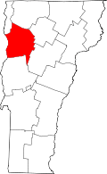 | |
| Towns | ||
| Villages | ||
| CDPs | ||
| Unincorporated communities | ||
Montpelier (capital) | |
| Regions | |
| Counties | |
| Cities | |
| Towns (pop. >5000) | |
| Festivals | |
| Topics |
|
| Society |
|