Linganore, Maryland
| Linganore, Maryland Lake Linganore | |
|---|---|
| Census-designated place | |
 Linganore  Linganore Location in Maryland | |
| Coordinates: 39°25′2″N 77°18′39″W / 39.41722°N 77.31083°WCoordinates: 39°25′2″N 77°18′39″W / 39.41722°N 77.31083°W | |
| Country |
|
| State |
|
| County |
|
| Area | |
| • Total | 6.0 sq mi (15.5 km2) |
| • Land | 5.8 sq mi (14.9 km2) |
| • Water | 0.2 sq mi (0.6 km2) |
| Elevation | 440 ft (130 m) |
| Population (2010) | |
| • Total | 8,543 |
| • Density | 1,488/sq mi (574.5/km2) |
| Time zone | Eastern (EST) (UTC-5) |
| • Summer (DST) | EDT (UTC-4) |
| ZIP code | 21774 |
| Area code(s) | 301 and 240 |
| FIPS code | 24-47040 |
| GNIS feature ID | 0588687[1] |
| Website |
www |
Linganore is a census-designated place (CDP) in Frederick County, in the U.S. state of Maryland. It consists of the area around Lake Linganore, a residential community governed by a homeowners association, located east of the city of Frederick. As of the 2010 census the CDP had a population of 8,543.[2] Prior to 2010, the area was part of the Linganore-Bartonsville CDP. The mailing address for the area is Lake Linganore, with a ZIP code of 21774.
Geography
The community is in eastern Frederick County, on both sides of Linganore Creek, a west-flowing tributary of the Monocacy River and part of the Potomac River watershed. The neighborhoods of the community surround Lake Linganore, an impoundment on the creek, and extend south to Interstate 70, between New Market to the east and Bartonsville and Spring Ridge to the west. Downtown Frederick is 7 miles (11 km) west of the center of Linganore.
According to the U.S. Census Bureau, the Linganore CDP has a total area of 6.0 square miles (15.5 km2), of which 5.8 square miles (14.9 km2) is land and 0.2 square miles (0.6 km2), or 4.15%, is water.[2]
References
- ↑ U.S. Geological Survey Geographic Names Information System: Linganore, Maryland
- 1 2 "Geographic Identifiers: 2010 Census Summary File 1 (G001), Linganore CDP, Maryland". American FactFinder. U.S. Census Bureau. Retrieved June 1, 2016.
External links
- Lake Linganore Association at Eaglehead, homeowners' association
Municipalities and communities of Frederick County, Maryland, United States | ||
|---|---|---|
| Cities | 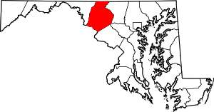 | |
| Towns | ||
| Village | ||
| CDPs | ||
| Other communities |
| |
| Footnotes | ‡This populated place also has portions in an adjacent county or counties | |