Columbia, Maryland
| Columbia, Maryland | |
|---|---|
| Planned community | |
|
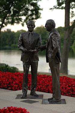
The People Tree statue, by Pierre du Fayet, which was dedicated on June 21, 1967.[1] | |
| Motto: "The Next America!"[2] | |
 Location of Columbia, Maryland | |
 Columbia  Columbia Location within the state of Maryland | |
| Coordinates: 39°12′13″N 76°51′25″W / 39.20361°N 76.85694°W | |
| Country |
|
| State |
|
| County |
|
| Founded | June 21, 1967[3] |
| Founded by | James Rouse |
| Named for | Columbia |
| Area | |
| • Total | 32.2 sq mi (83.4 km2) |
| • Land | 31.9 sq mi (82.7 km2) |
| • Water | 0.3 sq mi (0.7 km2) |
| Elevation | 407 ft (124 m) |
| Population (2013[4]) | |
| • Total | 103,683 |
| • Density | 3,200/sq mi (1,200/km2) |
| The CDP includes areas not part of Columbia proper as defined by the Columbia Association. | |
| Time zone | Eastern (EST) (UTC−5) |
| • Summer (DST) | EDT (UTC−4) |
| ZIP codes | 21044-21046 |
| Area code(s) | 410, 443, 301 |
| FIPS code | 24-19125 |
| GNIS feature ID | 0590002 |
| Highways | I-95, I-70, US 29, MD 32, MD 100, MD 108, MD 175 |
| Website |
columbiaassociation |

Columbia is a planned community comprising 10 self-contained villages, located in Howard County, Maryland. It began with the idea that a city could enhance its residents' quality of life. Creator and developer James W. Rouse saw the new community in terms of human values, rather than merely economics and engineering. Opened in 1967, Columbia was intended to not only eliminate the inconveniences of then-current subdivision design, but also eliminate racial, religious, and class segregation.[5]
Columbia has consistently ranked in the top ten of CNN Money's Best Places to Live in America.[6]
Columbia proper consists only of that territory governed by the Columbia Association, but larger areas are included under its name by the U.S. Postal Service and the Census Bureau. These include several other communities which predate Columbia, including Simpsonville, Atholton, and in the case of the census, part of Clarksville. The census-designated place had a population of 103,683 according to 2013 Census estimates,[7] making it the second most populous community in Maryland after Baltimore.[8]
History
Columbia's origins come from a crossroads in eastern Howard County formed by the Columbia Turnpike Road Company when it built a road from the Montgomery Courthouse to Baltimore called the "Columbia Road", now known as U.S. Route 29. A small post office at the crossroads of the turnpike and Old Annapolis Road (present-day MD 108) named "Columbia" opened on August 27, 1874, serving a population of 20 residents as late as 1912.[9][10] Developer and community associations prefer to acknowledge the completion of the first housing project in the 1960s as the foundation of "Columbia".[11][12]
In 1932 Melvin J. Berman moved from Alabama to Howard County where he bought the Olney Acres dairy farm. Starting his own land development company, he built the Laurel Shopping Center, and later joined the shopping center development company, Community Research and Development, along with James Rouse.[14] In 1961 Berman pursued his own Howard County for the company's next development.[15] In 1962 Berman took interest in a 1,032-acre (418 ha) parcel of land assembled by land developer Robert Moxley comprising four farm properties from the Carroll, Kahler, Wix, and his uncle James R. Moxley Sr's families.[16] Close to 15,000 acres (6,100 ha) were desired to create a parcel large enough for an envisioned 100,000-person development.
Jack Jones, an attorney from Rouse's firm of Piper Marbury set up a grid system to secretly buy land through dummy corporations like the "Alaska Iron Mines Company" to keep costs low.[17][18] Some of these included Howard Research and Development Corporation, Columbia Industrial Development Corporation, 95-32 Corporation, 95-216 Corporation, Premble, Inc., Columbia Mall, Inc., Oakland Ridge Industrial Development Corporation, and Columbia Development Corporation. Moxley's firm Security Realty Company (now Security Development Group Inc),[19] negotiated most of the land deals for Jones, becoming his best client.[19][20][21] CRD accumulated 14,178 acres (57.38 km2), 10 percent of Howard County, from 140 separate owners. Rouse was turned down in financing from David Rockefeller, who recently cancelled a planned Rouse "Village" concept Pocantico Hills.[22] The $19,122,622 acquisition was then funded by Rouse's former employer Connecticut General Life Insurance in October 1962 at an average price of $1,500 per acre ($0.37/m²). The town center land of Oakland Manor was purchased from Isadore Guldesky who was turned down from building high-rises on the site by Rob Moxley's brother, County Commissioner and land developer Norman E. Moxley. Sensing that he had a key property, he requested $5 million for his 1000 acres, signing an agreement by hand on a land plat.[23] The competition between Rouse and Guldesky carried over to the competing Tysons Corner Center and Tysons Galleria projects with each other hiring their competitor's employees.[24]
By late 1962, citizens had elected an all-Republican three-member council. J. Hubert Black, Charles E. Miller, and David W. Force campaigned on a slow-growth ballot, but later approved the Columbia project.[25] The Howard County Planning Commission Chairman Wilmer Sanner declared, "if this adds to the orderly development of the county, that's what we are looking for."[26] That July Sanner sold the majority of his 73-acre (30 ha) Simpsonville farm to Howard Research prior to the public announcement.[27] In October 1963, the acquisition was revealed to the residents of Howard County, putting to rest rumors about the mysterious purchases. These had included theories that the site was to become a medical research laboratory or a giant compost heap. Despite the moniker of being a "planned city" the planning for the city occupied Rouse officials for most of 1964 after the announcement while marketing director Scott Ditch was brought from the Cross Keys development to promote the project to community groups.[26][28]
In December 1964 the zoning was rejected by the planning director Tom Harris Jr. for handing nearly all planning control to the developer. A media push was instituted to approve the zoning by Dorris Thompson of The Howard County Times, Seymour Barondes of the Howard County Civic Association, and Anita Iribe of the League of Women Voters.[29] In June 1965 zoning was approved for the project, and Howard Research and Development entered into a $37.5 million construction deed backed by the property.[30][31] Development was temporarily stalled in October 1965 when James and Anna Hepding of Simpsonville sued the planning board stating New Town zoning was a form of Spot zoning benefiting a sole property owner. The case was dropped when developer Homer Gudelsky purchased the estate.[32] Ten years later, Councilman Charles E. Miller stated that if he could do it over again, he wouldn't have approved Columbia. He felt exploited and felt the subsidized housing would become a problem for the rest of the county.[33]

At this unveiling on 21 June 1967 James Rouse described Columbia as a planned new city which would avoid the leap-frog and spot development threatening the county. The new city would be complete with jobs, schools, shopping, and medical services, and a range of housing choices. Property taxes from commercial development would cover the additional services with which housing would burden the county. The urban planning process for Columbia included not only planners, but also a convened panel of nationally recognized experts in the social sciences, known as the Work Group. The fourteen member group of white men and one woman, Antonia Handler Chayes met for two days, twice a month, for half a year starting in 1963.[34] The Work Group suggested innovations for planners in education, recreation, religion, and health care, as well as ways of improving social interactions. Columbia's open classrooms, interfaith centers, and the then-novel idea of a health maintenance organization (HMO) with a group practice of medical doctors (the Columbia Medical Plan) sprung from these meetings. The community's physical plan, with neighborhood and village centers, was also decided. Columbia's "New Town District" zoning ordinance gave developers great flexibility about what to put where, without requiring county approval for each specific project.
In 1968, Vice Presidential candidate, Spiro Agnew referenced Columbia to reporters "Government should act as a catalyst to encourage the local governments to encourage industry and business to move next to a planned community", "I want to lessen the density in the ghettos, and concurrently rebuild the ghetto areas".[35] In 1969, County Executive Omar J. Jones felt that the increase in tax base was lagging behind the need for infrastructure as the operating budget doubled to $15 million in three years.[36] Crime rates shot up around the county by 30-50% a year, with hot spots around the development.[37][38] By 1970, the project required additional financing to continue, borrowing $30 million from Connecticut General, Manufacturers Hanover Trust, and Morgan Guaranty. In 1972, amendments to New Town zoning were proposed to place a maximum height for buildings and maintain the original density limit of 2.2 units per acre were opposed by Rouse allies including the Columbia Association, Ellicott City Businessman's Association and Columbia Democratic Club.[39] By 1974, the amount owed reached $100,000 million, prompting partner Connecticut General to consider bankruptcy. An effort to create a special taxing district in 1978 and an effort to incorporate with a mayor in 1979 failed.[40] In 1985 CIGNA (Connecticut General) divested itself of the project for $120 million. By 1990 Howard Research and Development owed $125,162,689.00[41]>[31] In 2004 the project was sold to General Growth Properties which went bankrupt in 2008. General Growth Properties submitted a plan for increasing density throughout Columbia in 2004 which was unanimously voted down.[42] Ownership of the project fell to the previous Rouse subsidiary The Howard Hughes Corporation. Howard Hughes submitted a new plan to increase density in 2010 under the Ulman administration that passed unanimously.
Columbia was never incorporated; some governance, however, is provided by the non-profit Columbia Association, which manages common areas and functions as a homeowner association with regard to private property. The first boards were filled entirely with Rouse Company appointees.[36] The first manager of the Columbia Association was John Estabrook Slayton (d. 1967). For Slayton's contributions to the early planning of Columbia, the community center in the Wilde Lake village, Slayton House, was named for him. Wilde Lake was the first village area to be developed in Columbia; accordingly, the town's first high school was Wilde Lake High School, which opened in 1971 as a "model school for the nation". Constructed in the open classroom style, it was razed in 1994 but reconstructed on the same site in 1996.
Two historic buildings in Columbia, Dorsey Hall and Woodlawn, were listed on the National Register of Historic Places in 1973.[43] Both were once homes of prominent Howard County citizens. Most historic buildings, mills and plantations within Columbia that qualified for the register, such as Oakland Manor,[44] were not submitted by Rouse company affiliates.
Master plan

To achieve the goals set forth by the Work Group, Columbia's Master Plan called for a series of ten self-contained villages, around which day-to-day life would revolve. The centerpiece of Columbia would be The Mall in Columbia and man-made Lake Kittamaqundi.
Villages and neighborhoods

The village concept aimed to provide Columbia a small-town feel (like Easton, Maryland, where James Rouse grew up). Each village comprises several neighborhoods. The village center may contain middle and high schools. All villages have a shopping center, recreational facilities, a community center, a system of bike/walking paths, and homes. Four of the villages have interfaith centers, common worship facilities which are owned and jointly operated by a variety of religious congregations working together.
Most of Columbia's neighborhoods contain single-family homes, townhomes, condominiums and apartments, though some are more exclusive than others. The original plan, following the neighborhood concept of Clarence Perry, would have had all the children of a neighborhood attend the same school, melding neighborhoods into a community and ensuring that all of Columbia's children get the same high-quality education. Rouse marketed the city as being "color blind" as a proponent of Senator Clark's fair housing legislation. If a neighborhood was filled with too many purchasers of a single race, houses would be blocked until the desired ratio was met.[45]
- Village – Neighborhoods (in order of residential opening)
- Wilde Lake – (Est. 1967) Bryant Woods, Faulkner Ridge, Running Brook, The Birches
- Harper's Choice – Longfellow, Swansfield, Hobbit's Glen
- Oakland Mills – (Est. 1969) Thunder Hill, Talbott Springs, Stevens Forest
- Long Reach – (Est. 1971) Phelps Luck, Jeffers Hill, Locust Park, Kendall Ridge
- Owen Brown – (Est. 1972) Dasher Green, Elkhorn, Hopewell
- Town Center – (Est. 1974) Vantage Point, Banneker, Amesbury, Creighton's Run, and Warfield Triangle
- Hickory Ridge – (Est. 1974) Clemens Crossing, Hawthorn, Clary's Forest
- Kings Contrivance – (Est. 1977) Dickinson, Huntington, Macgill's Common
- Dorsey's Search – (Est. 1980) Dorsey Hall, Fairway Hills
- River Hill – (Est. 1990) Pheasant Ridge, Pointers Run
Columbia takes its street names from famous works of art and literature: for example, the neighborhood of Hobbit's Glen takes its street names from the work of J. R. R. Tolkien; Running Brook, from the poetry of Robert Frost; and Clemens Crossing, from the work of Mark Twain. The book Oh, you must live in Columbia! chronicles the artistic, poetic, and historical origins of the street and place names in Columbia.[46]
Columbia today
In 2006, Money magazine ranked Columbia (together with Ellicott City, its neighbor to the north) #4 out of the 100 "Best Places to Live" in the United States (among small cities, defined as having populations between 50,000 and 300,000).[47] In 2008, Columbia and Ellicott City were ranked #8 on this list.[48] In 2010, Columbia and Ellicott City were ranked #2 on this list.[49] In 2012 and 2014, Columbia and Ellicott City were ranked, respectively, #8 and #6 on this list.[50][51] In 2016, Columbia ranked #1 in the country on this list. (Columbia and Ellicott City were ranked separately in 2016.)[52]
Further expansion

"The Downtown Columbia Plan" is a 2010 amendment to the county's General Plan of expansion. It is a framework for the revitalization of Downtown Columbia over the next thirty years. Development plans for downtown projects in the years ahead will include details for that project such as neighborhood design guidelines, environmental restoration, public amenities and infrastructure. These development plans must adhere to the framework of the Downtown Columbia Plan as required by the zoning legislation. Over the life of the Downtown Columbia development project, as much as 13 million square feet of retail, commercial, residential, hotel and cultural development is planned.[53] To be accomplished in three phases, the plan calls for:
The formation of the non-profit Columbia Downtown Housing Corporation to build an additional 5,500 units of low income housing placed downtown in exchange for increased zoning density for other projects.[54] Additional development includes 4.3 million square feet of commercial office space, 1.25 million square feet of retail space, 640 hotel rooms, Merriweather Post Pavilion redevelopment and a multi-modal transportation system.[55]
The Downtown Columbia Plan also has sustainability features, including goals for saving water and energy, and for ecology and livability.
Geography
The center of Columbia is located at 39°12.5′N 76°52′W / 39.2083°N 76.867°W. However, because it is unincorporated, there is confusion over its exact limits. In the strictest definition, Columbia comprises only the land governed under covenants by the Columbia Association. This is a considerably smaller area than the census-designated place (CDP) as defined by the United States Census Bureau, which has a total area of 32.2 square miles (83.4 km2), of which 31.9 square miles (82.7 km2) is land and 0.27 square miles (0.7 km2) of it (0.80%) is water.[56] The CDP includes a number of older communities which do not lie within the CA's purview, including the Holiday Hills, Diamondback, and Allview subdivisions and the former town of Simpsonville, as well as some land on the east side of Clarksville. These areas are not part of the "new town", and are not directly served by its amenities. Some of these areas are included in Columbia ZIP codes by the post office, and some are not.
The city lies in the Piedmont region of Maryland, with its eastern edge at the fall line. The climate is that of central Maryland, tending to hot, humid summers and cool to cold and wet winters. The primary landforms in Columbia are rolling hills and stream valleys; Columbia's road network is laid out to follow the terrain, with many winding streets and cul-de-sacs. Elevations range from about 200 to 500 feet (61 to 152 m) above sea level. Most of Columbia is drained by the Middle Patuxent and Little Patuxent rivers. There are three artificial lakes, created by damming of tributary streams during city construction. In 1965, the Rouse Company leased 7,000 acres (2,800 ha) of farmland staged for development, and earmarked 4,000 acres (1,600 ha) of oak forest for timber harvesting. The company developed a sapling planter to replant sections of cleared land that would use Columbia's W.R. Grace developed fertilizers.[57] A outer ring of green-space was abandoned early in the project because the combination with the already required river buffers would have reduced profitable land available for building.[58] Along with Symphony Woods, many other stands of mature trees have been temporarily maintained in Columbia, including the large Middle Patuxent Environmental Area in the western part of the city between Harper's Choice and River Hill villages, protecting much of the river valley from development.
Culture
Religion
Rouse believed that individual churches were a waste of developable land. Dr. Stanley Hallet advised the 1964 work group to economically abandon "The extravagance of church life" in favor of ecumenical establishments that focused resources on retreat centers and non-profit religious corporations.[59] The Rouse company discouraged individual congregations from purchasing land from the company. In 1966 the Columbia Religious Facilities Corporation was founded to lease interfaith centers to congregations.[60][61] On 22 June 1969 $2.5 million in church donations applied to the CFRC to purchase Columbia land and build an interfaith facility in Wilde Lake. The organization formed the Interfaith Housing Corporation (now the Columbia Housing Corporation) to purchase 300 units of low and moderate income housing in the development with Federal Housing Authority funding.[62][63]
Recreation
Recreation has always been an important part of the Columbia concept. The homeowners association, the Columbia Association, known to Columbians as "CA," builds, operates and maintains most of these facilities. CA operates a variety of recreational facilities, including 23 outdoor swimming pools, six indoor pools, two water slides, ice and roller skating rinks, an equestrian center, a sports park with miniature golf, a skateboard park, batting cages, picnic pavilions, clubhouse and playground, three athletic clubs including the 24/7 Supreme Sports Club, numerous indoor and outdoor tennis, basketball, volleyball, squash and racquetball courts, and running tracks. In February 2006 LifeTime Fitness (a Minnesota company) opened a 24/7 health club at the edge of the Columbia Gateway industrial park. This facility includes one outdoor and two indoor pools (with water slides), racquetball courts, basketball courts, fitness equipment, and pilates and yoga facilities.
There are three lakes (Lake Kittamaqundi, Lake Elkhorn, and Wilde Lake) surrounded by parkland for sailing, fishing, and boating; 80 miles (130 km) of paths for jogging, strolling and biking; and 148 tot lots and play areas.
Nine village centers, 15 neighborhood centers, and four senior centers provide space for a large variety of community activities. There are a variety of fairs and celebrations throughout the year, including entertainment on the lakefront of Lake Kittamaqundi during the summer and the Columbia Festival of the Arts.
Columbia also has garden plots for rent, under the guidance of the Columbia Gardeners, which has been in existence since the 1970s. There are about 350 garden plots at three sites in Columbia, with each garden rented for a nominal fee (currently $30 per year). (Columbia Flyer, Doug Miller "Turning over a new leaf could be growing concern", May 31, 2007, page 17)
The Rev3 Triathlon is held every October in Columbia. It is a major national event, both half iron and full ironman distances.
Entertainment/performing arts


In the absence of nightclubs, Columbia relies on local bars to bring in bands. Clyde's (near the Columbia Mall and on Lake Kittamaqundi), Sonoma's (in Owen Brown), along with Nottingham's Tavern and The Green Turtle (near Dobbin Center) regularly bring in groups to perform.
Merriweather Post Pavilion, a well-known outdoor concert venue, attracts many prominent performers. In addition, there are several performing arts organizations that present professional theater, including Toby's Dinner Theatre, which has produced the area premieres of several musicals.
Columbia also offers chamber music concerts, children's programs, community outreach programs, master classes, and pre-concert lectures and discussions through The Candlelight Concert Society (Candlelight), a non-profit organization formed by Columbia residents to provide Chamber Music concerts since 1972.
Shopping
The Mall in Columbia, located in Town Center, is a large regional shopping mall with five anchor department stores (Nordstrom, Lord & Taylor, Sears, Macy's, and JCPenney), a multiplex movie theater, and more than 200 stores and restaurants.
There are several other major competing shopping centers in East Columbia, including Dobbin Center strip mall opened in 1983, Snowden Square big box retail on the remainder of the GE industrial site, Columbia Crossing I and II big box retail started in 1997, and Gateway Overlook.[64]
Columbia's nine "village centers" provide residents with nearby shopping as well, often including supermarkets, gas stations, liquor stores, dry cleaners, restaurants, and hair salons. The village centers are laid out so that individual stores are not visible from the road, unlike traditional strip malls. The arrangement is criticized because it makes it difficult for newcomers and non-residents to know what shopping is available; it is praised for eliminating much of the garishness of roadside America.
The village centers have evolved over time. The Oakland Mills Village Center had a traditional Village Center layout—stores located off a central corridor—until its demolition in the late 1990s. It has since been replaced with a more traditional strip mall managed by Cedar Realty Trust. The Rouse company abandoned the village center concept in 2002, selling off the assets to Kimco Realty for $120 million.[65] The Kings Contrivance Village Center underwent major construction in 2007 and 2008 when a new Harris Teeter supermarket was added to the center, but maintained the original character of stores around a central corridor and plaza. Owen Brown village center is now managed by GFS Realty, and the Long Reach Village center was declared blighted and purchased by Howard County for resale in 2014.[66]
Economy
James Rouse conceived of a city, not a suburban bedroom community, and a large area on the eastern edge was allocated for industrial purposes. The centerpiece of this aspect of the development was a General Electric appliance plant on a 1,125-acre (4.55 km2) site previously operated as a cattle farm.[67][68] After an injunction attempt was blocked in 1969, the plant began operations in 1972 peaking at 2,300 of the predicted 12,000 jobs and was closed in 1990, with all but 21 acres (85,000 m2) of the property being sold back to Howard Research and Development.[69] After toxic waste remediation from onsite sludge dumping, one section was redeveloped for big box retail; the remainder became the large Gateway Commerce office complex, still being expanded.[70][71] In 1968, Bendix Field Engineering moved to a new 143,000 sq foot facility on the historic Woodlawn Plantation where it was used for engineering activity. Howard county purchased the vacant facility creating the Maryland Center for Entrepreneurship in 2011 which relocated to the vacant Patuxent Publishing building in 2014.[72][73] There is still a smaller industrial area to the south of this, but by and large East Columbia is dominated by commercial real estate: office, retail, and wholesale in contrast to the original plan, which saw the Town Center area as the commercial center of Columbia.[74]
The U.S. federal government is the source of many jobs for Columbians. Several large U.S. Department of Defense installations and R&D facilities surround Columbia, the largest being the National Security Agency at Fort George G. Meade, and the Applied Physics Laboratory, both pre-dating the establishment of Columbia. Companies which have had research facilities in the area include W.R. Grace and Company and Westvaco. Further afield, many Columbians commute to government and government contractor jobs in the Baltimore and Washington, D.C. area.
Companies based in Columbia include W.R. Grace and Company,[75][76] Sourcefire, PetMeds, MICROS Systems, Martek Biosciences, Integral Systems, Corporate Office Properties Trust, Shimadzu Scientific Instruments, Inc., customized business tablet computer provider JACS Solutions[77] and the consumer research company Arbitron. When MaggieMoo's was an independent company, its headquarters was in the Columbia CDP.[76][78]
Demographics
NOTE: The CDP includes considerable areas which are not part of the planned community.
2010 census
| Historical population | |||
|---|---|---|---|
| Census | Pop. | %± | |
| 1970 | 8,815 | — | |
| 1980 | 52,518 | 495.8% | |
| 1990 | 75,883 | 44.5% | |
| 2000 | 88,254 | 16.3% | |
| 2010 | 99,615 | 12.9% | |
| | ||
| Race | Population | % of Total |
|---|---|---|
| Total | 99,615 | 100 |
| Caucasian | 55,322 | 55 |
| African American | 25,231 | 25 |
| Asian | 11,390 | 11 |
| Hispanic | 7,884 | 7 |
| Two or More Races | 4,424 | 4 |
| Other | 2,811 | 2 |
| Three or more races | 465 | < 1% |
| American Indian | 393 | < 1% |
| [79] | ||
The 2009-2013 census estimates report the median income for a household in the CDP was $99,877. The per capita income for the CDP was $46,374. About 4.1% of families and 6.6% of the population were below the poverty line, including 8.8% of those under age 18 and 6.4% of those age 65 or over.[80]
2000 census
As of the census[81] of 2000, there were 88,254 people, 34,199 households, and 23,118 families residing in the CDP. The population density was 3,202.0 people per square mile (1,236.4/km²). There were 35,281 housing units at an average density of 1,280.0 per square mile (494.3/km²). The racial makeup of the CDP was 66.52% White, 21.47% Black or African American, 0.26% Native American, 7.30% Asian, 0.05% Pacific Islander, 1.63% from other races, and 2.76% from two or more races. 4.12% of the population were Hispanic or Latino of any race. 14% of Columbia's residents were German, 11% Irish, 10% English, 5% Italian, 4% Polish, 2% Russian, 2% Scottish, 2% Indian, 2% Chinese, 2% Korean, 2% Sub-Saharan African, 2% French, and 2% West Indian.[82]
There were 34,199 households out of which 35.9% had children under the age of 18 living with them, 53.4% were married couples living together, 11.2% had a female householder with no husband present, and 32.4% were non-families. 25.6% of all households were made up of individuals and 5.1% had someone living alone who was 65 years of age or older. The average household size was 2.54 and the average family size was 3.09.
In the CDP the population was spread out with 26.3% under the age of 18, 6.7% from 18 to 24, 34.1% from 25 to 44, 25.5% from 45 to 64, and 7.5% who were 65 years of age or older. The median age was 36 years. For every 100 females there were 93.1 males. For every 100 females age 18 and over, there were 88.7 males.
Education and libraries
Columbia's public schools are operated by the Howard County Public School System. As of the 2007–2008 school year, the following high schools served some part of Columbia:[83]
- Atholton[84]
- Centennial
- Hammond[85]
- Howard[86]
- Long Reach[87]
- Oakland Mills[88]
- River Hill[89]
- Wilde Lake[90]
Most of these schools also serve students from outside Columbia, as is also the case with some middle and elementary schools.
Colleges and universities
There are no conventional four-year colleges or universities in Columbia, but several other college-level programs have facilities there. Howard Community College is located near the town center, while the University of Phoenix, American Career Institute, Lincoln College of Technology, Loyola University Maryland, University of Maryland, Baltimore County, Maryland University of Integrative Health, and Johns Hopkins University have facilities on the east side of town at Columbia Gateway Business Park.
In 1966, Howard Community College (HCC) was founded by the Board of Education in Howard County and formally authorized by the Howard County Commissioners Charles E. Miller, J. Hubert Black, and David W. Force. In addition to its original campus in Columbia, it now has satellite campuses in Mount Airy, Laurel, and East Columbia, in the Columbia Gateway Business Park.
Howard County Public Library
Howard County Public Library is consistently top rated among the nation's public library systems according to Hennen's American Public Library Ratings (HAPLR).[91] Two of the six branches of the Howard County public library system are in Columbia, including the Central Branch in Town Center and the East Columbia Branch in Owen Brown.
Transportation
Public Transit
Columbia's initial plan called for a minibus system connecting the village centers on a distinct right-of-way that allowed denser development along the route.[92] The routes were not constructed, though minibuses were operated by the Columbia Association under the name ColumBus. These were eventually taken over by Howard County. Six Howard Transit bus routes now serve Columbia and connect it with its neighboring areas (such as Ellicott City and BWI Airport), while several Maryland Transit Administration (MTA) routes provide access to and from both Washington and Baltimore. MTA weekday commuter bus service connects Columbia to the Washington Metro system. There are no rail stations within Columbia, although the Dorsey MARC Train station is served by Howard Transit buses.
The Regional Transportation Agency of Central Maryland provides local bus service as well as the Washington Metropolitan Area Transit Authority and Maryland Transit Administration. RTA Bus Routes include: 401, 402, 403, 404, 405, 406, 407, 408, 501, and 503.
Roads
Columbia has a number of roadways that serve the city (see below). All of these highways allow Columbia access to nearby Baltimore, Washington, D.C. and Annapolis.
- U.S. Route 29 Columbia Pike, runs north-south connecting Columbia to Ellicott City and Washington, D.C.
- Interstate 95, runs north-south connecting Columbia to Baltimore and Washington, D.C.
- MD 32 Patuxent Freeway, runs east-west connecting Columbia to Sykesville and Annapolis.
- MD 100 Paul T. Pitcher Memorial Highway, runs east from U.S. Route 29 connecting Columbia to Glen Burnie.
- MD 175 Rouse Parkway, a central artery that runs east-west from the Town Center to Jessup.
- MD 108 Clarksville Pike-Waterloo Road,forms the northern boundary of the city by running east-west from Clarksville to Ellicott City.
Infrastructure
Health
Medical care is available at Howard County General Hospital, affiliated with Baltimore's Johns Hopkins Hospital. The Columbia Medical Plan was founded in 1967 as a health maintenance organization (HMO) available to citizens of Columbia.[93][94] In more recent years, however, this plan has divided into separate medical groups that simply share the Twin Knolls buildings. Today, there is a Kaiser Permanente facility located in the Columbia Gateway industrial park. There are also a number of clinics, such as the Righttime Medical Care center and Patient First.
Climate
Columbia has a humid subtropical climate, with cool winters and hot, muggy summers.
| Climate data for Columbia, MD | |||||||||||||
|---|---|---|---|---|---|---|---|---|---|---|---|---|---|
| Month | Jan | Feb | Mar | Apr | May | Jun | Jul | Aug | Sep | Oct | Nov | Dec | Year |
| Average high °F (°C) | 42 (6) |
46 (8) |
55 (13) |
66 (19) |
75 (24) |
84 (29) |
88 (31) |
87 (31) |
79 (26) |
68 (20) |
58 (14) |
46 (8) |
66.2 (19.1) |
| Average low °F (°C) | 25 (−4) |
27 (−3) |
35 (2) |
44 (7) |
55 (13) |
64 (18) |
69 (21) |
68 (20) |
60 (16) |
48 (9) |
38 (3) |
29 (−2) |
46.8 (8.3) |
| Average precipitation inches (mm) | 3.16 (80.3) |
3.14 (79.8) |
4.10 (104.1) |
3.81 (96.8) |
4.56 (115.8) |
4.23 (107.4) |
4.05 (102.9) |
3.43 (87.1) |
4.60 (116.8) |
3.98 (101.1) |
4.21 (106.9) |
3.77 (95.8) |
47.04 (1,194.8) |
| Source: [95] | |||||||||||||
Sister cities
Columbia is a sister city to the planned cities of Cergy-Pontoise, France and Tres Cantos, Spain. Columbia Association International and Multicultural Programs Advisory Committee organizes a summer exchange program for French and Spanish students enrolled in Howard County Public Schools. In 2013, CA announced its new sister city relationship with Tema, a port city in Ghana. The official celebration will be marked with a Ghana Fest on November 17, 2013. They currently only have a friendship agreement with Tema, and an advisory committee is planning to sign the official SCI agreement by 2015. A proposal to add Cap-Haïtien, Haiti as a sister city is under consideration.[96]
-
 Cergy-Pontoise, France (1977)[97]
 -
 Tres Cantos, Spain (1990)[97]
-
 Tema, Ghana (2013)
Related cities
The Rouse Company now owned by The Howard Hughes Corporation owns and operates multiple HUD Title VII-New Town planned community developments along with Columbia. These include The Woodlands, Texas, Bridgeland Community, Texas and Summerlin, Nevada.[98]
Notable people

- David Adkins,[99] actor and playwright.
- Stephen Amidon, author, whose 2000 novel, The New City, is set in a fictionalized Columbia in the 1970s
- Bob Beaumont (1932–2011), founder of Citicar, an electric automobile manufacturer from 1974 to 1977.[100]
- Jayson Blair, disgraced former New York Times reporter
- Zach Brown, linebacker for the NFL's Tennessee Titans
- Michael Chabon, Pulitzer Prize–winning author
- Dan Charnas, journalist and author of "The Big Payback: The History of the Business of Hip-Hop"[101]
- Frank Cho, creator of Liberty Meadows comic strip
- George Colligan, New York–based jazz pianist
- Cristeta Comerford, White House Executive Chef
- D'Monroe, Broadway and Off-Broadway actor
- Jack Douglass, internet personality on YouTube[102]
- John Douglas, gridiron football player[103]
- Mary Downing Hahn, award-winning author of young adult literature
- Kevin Frazier, journalist and TV broadcaster
- Gallant, singer-songwriter
- Tom Green, ultra-runner[104]
- Greg Hawkes, keyboardist for new wave band The Cars
- David Hobby, professional photographer and author of the Strobist.com lighting blog
- Stephen Hunter, Pulitzer Prize-winning film critic and author
- Kerry G. Johnson, award-winning caricaturist, cartoonist and children's book illustrator
- Ian Jones-Quartey, creator of the webcomic RPG World
- Robert Kolker, author and editor
- Mark Levine, New York City Council member
- Laura Lippman, award-winning mystery author
- Steve Lombardozzi, former professional baseball player
- Steve Lombardozzi, Jr. professional baseball player
- Suzanne Malveaux, CNN reporter
- Aaron Maybin, defensive end for NFL's New York Jets
- Aaron McGruder, animator and cartoonist (The Boondocks)
- Edward Norton, Academy Award–nominated actor and grandson of James Rouse, made his professional debut at age 8 at Toby's Dinner Theatre in the Town Center
- Randy Pausch, professor of computer science at Carnegie Mellon University, author of The Last Lecture
- Elise Ray, Olympic gymnast
- James W. Rouse, urban planner, real estate developer and philanthropist; grandfather of actor Edward Norton
- Christian Siriano, fashion designer, winner of fourth season of Project Runway (born in Columbia)
- Dave Sitek, guitarist and music producer, member of the band TV on the Radio
- Linda Tripp, central figure in the Monica Lewinsky scandal
- Terry Virts, astronaut
- Void, punk band
- Air Commodore Sir Frank Whittle, OM, KBE inventor of the jet engine
References
- 1 2 Anderson, Jessica (January 31, 2012). "Columbia Association to drop 'People Tree' from logo". The Baltimore Sun.
- ↑ http://nexus.umn.edu/Papers/NextAmerica.pdf
- ↑ "Columbia Archives". Columbia Association.
- ↑ "FactFinder". United States Census Bureau. U.S. Census Bureau. Retrieved 2014-11-17.
- ↑ Galambos, Louis (2011). The Creative Society-and the Price Americans Paid for It. Cambridge University Press. p. 160. ISBN 1107600995.
- ↑ "Best Places to Live 2014". Money. Retrieved 18 October 2014.
- ↑ "Profile of General Population and Housing Characteristics: 2010 Demographic Profile Data (DP-1): Columbia CDP, Maryland". U.S. Census Bureau, American Factfinder. Archived from the original on September 11, 2013. Retrieved February 22, 2012.
- ↑ http://www.mdp.state.md.us/msdc/census/cen2000/PL94-171/ByCDP/cdp0090t.pdf
- ↑ "Smithsonian Postal Museum" (PDF). Archived from the original (PDF) on 18 May 2014. Retrieved 19 May 2014.
- ↑ "Boyd's Business Directory 1875". Retrieved 11 June 2014.
- ↑ J.M. Hopkins (1878). Howard County - District 6, Guilford, Savage Factory, Annapolis Junction, Laurel City.
- ↑ Writers' Program of the Work Projects Administration in the State of Maryland. Maryland: A Guide to the Old Line State. p. 317.
- ↑ Barbara Kellner. Columbia. p. 92.
- ↑ The Baltimore Sun. 29 Feb 1996. Missing or empty
|title=(help) - ↑ Ann Forsyth. Reforming Suburbia: The Planned Communities of Irvine, Columbia. p. 113.
- ↑ Edward Gunts (19 February 2012). "Columbia Marks 50 Years since Rouse started buying land for town". The Baltimore Sun.
- ↑ Charles Monroe Haar, Lance Liebman Little, Brown. Property and law. p. 685.
- ↑ Forsythe. Reforming Suburbia : The Planned Communities of Irvine, Columbia, and The Woodlands. p. 114.
- 1 2 Adam Sachs (16 November 1993). "Developer envisions 22 homes on 10 acres of Dasher Homestead Moxley has ties to Columbia's birth". The Baltimore Sun.
- ↑ Joseph R. Mitchell; David Stebenne. New City Upon a Hill: A History of Columbia, Maryland. p. 57.
- ↑ Barbara Kellner. Columbia. p. 10.
- ↑ Joseph R. Mitchell; David Stebenne. New City Upon a Hill: A History of Columbia, Maryland. p. 58.
- ↑ Gurney Breckenfeld. Columbia and the New Cities. p. 233.
- ↑ "H. Max Ammerman Dies; Development Suburban Malls". The Washington Post. 1 November 1988.
- ↑ The Baltimore Sun. 5 December 1962. Missing or empty
|title=(help) - 1 2 Joseph R. Mitchell; David Stebenne. New City Upon a Hill: A History of Columbia, Maryland. p. 56.
- ↑ Maryland State Archives Book 440. pp. 80–82.
- ↑ Jacques Kelly (20 June 2009). "Rouse Official Oversaw Naming Of Columbia's Streets, Helped Gain Harborplace Approval". The Baltimore Sun.
- ↑ Joseph Rocco Mitchell; David L. Stebenne. New City Upon a Hill. p. 64.
- ↑ Columbia Archives (14 June 1992). "Columbia's first 25 years: a chronology". The Baltimore Sun.
- 1 2 "HOWARD COUNTY, MARYLAND et al. v. HOWARD RESEARCH AND DEVELOPMENT CORPORATION et al." (PDF). Retrieved 14 February 2014.
- ↑ "Flashbacks". The Baltimore Sun. 17 October 1990.
- ↑ Michael J. Clark (19 June 1977). "At youthful age of 10, Columbia is feeling like a grown-up new town". The Baltimore Sun. p. B1.
- ↑ Joseph R. Mitchell; David Stebenne. New City Upon a Hill: A History of Columbia, Maryland. p. 68.
- ↑ Richard Reeves (25 August 1968). "Agnew Says Vice President Should Quit in a Major Rift". The Washington Post.
- 1 2 Ellen Hoffman (26 September 1969). "New Towners The Voiceless Marylanders, Columbia Citizens Seeking More Say". The Washington Post.
- ↑ Tom Huth (19 September 1972). "Howard County Boom Malignant or Benign?". The Washington Post.
- ↑ "Rural Howard County Goes on a Crime Alert". The Washington Post. 11 December 1971.
- ↑ Michael J Clark (22 June 1972). "Rouse campaigning against Columbia zoning amendments". The Baltimore Sun.
- ↑ Micheal J. Clark (21 February 1979). "Plan to Incorporate Columbia Faces Defeat". The Baltimore Sun.
- ↑ Joshua Olsen. A Biography of James Rouse. p. 234.
- ↑ "Howard Week". The Baltimore Sun. 19 September 2004.
- ↑ National Park Service (2008-04-15). "National Register Information System". National Register of Historic Places. National Park Service.
- ↑ "National Register Historic Listings Howard County". Retrieved 20 June 2014.
- ↑ Joseph Rocco Mitchell; David L. Stebenne. New City Upon a Hill. p. 85.
- ↑ "Publications: Books". Columbia Archives. Columbia Association.
- ↑ "Best Places to Live 2006 - Money Magazine". Money.
- ↑ "Best Places to Live 2008 - from Money Magazine". Money.
- ↑ "Best Places to Live 2010 - from Money Magazine". Money.
- ↑ "Best Places to Live 2012 - Top 100: 1-25 - Money Magazine". Money.
- ↑ "MONEY". MONEY.com. Retrieved 2016-04-06.
- ↑ http://time.com/money/4480692/columbia-maryland/
- ↑ "DOWNTOWN COLUMBIA PLAN: A General Plan Amendment" (PDF). Howard County, Maryland. 1 February 2010. Retrieved 2 October 2012.
- ↑ Lindsey McPherson (24 September 2012). "Group hopes to provide affordable housing in downtown Columbia". Patuxent.
- ↑ "FAQ Downtown Columbia, MD." Howard County, Maryland. 2012. <http://www.columbiamd.com/plan/faq/> Retrieved 2 October 2012
- ↑ "Geographic Identifiers: 2010 Demographic Profile Data (G001): Columbia CDP, Maryland". U.S. Census Bureau, American Factfinder. Archived from the original on September 11, 2013. Retrieved February 22, 2012.
- ↑ "HRD Howards Biggest Farmer". The Times. 31 March 1965.
- ↑ Joseph Rocco Mitchell; David L. Stebenne. New City Upon a Hill. p. 76.
- ↑ The Communicator: News of the Episcopal Church in Maryland. November 1966. Missing or empty
|title=(help) - ↑ Martin M. Chemers. Culture and Environment. p. 285.
- ↑ "Columbia Religious Facilities Corporation". Retrieved 11 November 2014.
- ↑ Joseph Rocco Mitchell; David L. Stebenne. New City Upon a Hill. p. 97.
- ↑ Nicholas Dagen Bloom. Suburban Alchemy: 1960s New Towns and the Transformation of the American Dream. p. 172.
- ↑ Joseph Rocco Mitchel; David L Stebenne. New City Upon a Hill. p. 142.
- ↑ International Council of Shopping Centers. 8 February 2002. Missing or empty
|title=(help) - ↑ Lavoie, Luke (30 May 2014). "Columbia market study presents recommendations". The Baltimore Sun.
- ↑ Laura Barnhardt (19 May 1996). "Farmers: town's forgotten pioneers In 1960s, they sold land to Rouse, making Columbia possible". The Baltimore Sun.
- ↑ "Columbia GE Plant Grows". The Washington Post. 17 May 1973.
- ↑ Joseph Rocco Mitchel; David L Stebenne. New City Upon a Hill. p. 141.
- ↑ "General Electric Company: Former Appliance Park East Facility: Columbia, MD" (PDF). Environmental Protection Agency. Retrieved 2008-10-22.
- ↑ "STATEMENT OF BASIS GENERAL ELECTRIC COMPANY COLUMBIA, MARYLAND EPA ID NO. MDD046279311 JUNE 2012" (PDF). Retrieved 4 July 2014.
- ↑ Peter Muncie (20 September 1968). "Bendix Field Unit To Move". The Baltimore Sun.
- ↑ Amanda Yeager (8 May 2014). "Howard Co. to buy Columbia Flier building as headquarters for business incubator". The Baltimore Sun.
- ↑ Nicholas Dagen Bloom. Merchant of Illusion: James Rouse, America's Salesman of the Businessman's Utopia. p. 114.
- ↑ "Grace in Maryland." W.R. Grace and Company. Retrieved on June 29, 2011. "Corporate Headquarters & Grace Davison Headquarters W.R. Grace & Co. 7500 Grace Drive Columbia, MD 2104"
- 1 2 "Columbia CDP, Maryland." U.S. Census Bureau. Retrieved on February 26, 2010.
- ↑ "JACS Solutions LLC - We bring the right Technology to your business".
- ↑ "Home" at the Wayback Machine (archived January 25, 1999). MaggieMoo's. January 25, 1999. Retrieved on February 26, 2010.
- ↑ "Columbia Maryland Population Statistics". US Census Bureau. Retrieved February 27, 2013.
- ↑ "Selected Economic Characteristics". Archived from the original on 2016-04-17. Retrieved 24 Dec 2014.
- ↑ "American FactFinder". United States Census Bureau. Archived from the original on 2013-09-11. Retrieved 2008-01-31.
- ↑ "Columbia, MD, Ancestry & Family History". Epodunk.com. Retrieved 2015-04-19.
- ↑ "Howard County High School Attendance Area Map" (PDF).
- ↑ "Atholton High School".
- ↑ "Hammond High School".
- ↑ "Howard High School".
- ↑ http://www.howard.k12.md.us/lrhs/home.html
- ↑ "Oakland Mills High School".
- ↑ "River Hill High School".
- ↑ "Home".
- ↑ Hennen's American Public Library Ratings. Hennen's American Public Library Ratings, Hennen's American Public Library Ratings (HAPLR), 2010, retrieved October 18, 2010
- ↑ Edward P. Eichler; Marshall Kaplan. The Community Builders. p. 69.
- ↑ Joseph Rocco Mitchell; David L. Stebenne. New City Upon a Hill. p. 99.
- ↑ Harold S. Luft. Health Maintenance Organizations: Dimensions of Performance. p. 345.
- ↑ "Monthly Averages for Columbia, MD (21044)". Weather.com. Retrieved March 19, 2012.
- ↑ Luke Lavoie (26 November 2014). "Columbia to consider adding sister city in Haiti". The Baltimore Sun.
- 1 2 http://www.columbiaassociation.com/content/getinvolved/teens/exchange_programs.cfm?expand=3
- ↑ "Howard Hughes Corporation Properties". Retrieved 2 December 2013.
- ↑ Rousuck, J. Wynn (29 September 1999). "Adkins discovers his home onstage". The Baltimore Sun. Retrieved 28 September 2015.
- ↑ Bunkley, Nick. "Bob Beaumont, Who Popularized Electric Cars, Dies at 79", The New York Times, October 29, 2011. Accessed October 30, 2011.
- ↑ "Paid In Full: An Interview With Dan Charnas, Author of "The Big Payback: The History of the Business of Hip-Hop" (Part 1)". Scottscope. Retrieved 2012-09-17.
- ↑ Brookes May (Oct 25, 2009). "Student strikes YouTube gold". The Eagle. Retrieved May 24, 2012.
- ↑ "JOHN DOUGLAS". profootballarchives.com. Retrieved November 17, 2014.
- ↑ Nitkin, Karen (November 21, 2007). "Tom Green Ultrarunner - A laid-back Columbia man is a pioneer in running races of 50 miles or longer". The Baltimore Sun. Retrieved May 5, 2016.
Further reading
- Joseph Rocco Mitchell and David L. Stebenne, New City Upon A Hill: A History of Columbia, Maryland (The History Press, 2007)
- Missy Burke, Robin Emrich and Barbara Kellner, Oh, you must live in Columbia: The origins of place names in Columbia, Maryland (2008)
- Barbara Kellner, Columbia – Images of America
External links
| Wikimedia Commons has media related to Columbia, Maryland. |
| Wikivoyage has a travel guide for Columbia (Maryland). |
- Columbia Association, Inc.
- Columbia Archives
- Columbia Maryland
- Stephen Amidon talks to Kojo Nnamdi about growing up in Columbia in the 1970s (interview)

| Administration |  | |
|---|---|---|
| County Council |
| |
| Landmarks | ||
| Transportation | ||
| Attractions | ||
| Education | ||
| Parks | ||
Municipalities and communities of Howard County, Maryland, United States | ||
|---|---|---|
| CDPs | 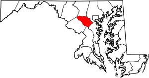 | |
| Villages | ||
| Unincorporated communities |
| |
| Footnotes | ‡This populated place also has portions in an adjacent county or counties | |
Annapolis (capital) | |
| Topics |
|
| Society | |
| Regions | |
| Cities | |
| Towns | |
| CDPs |
|
| Counties | |
| Rank | Name | County | Pop. | ||||||
|---|---|---|---|---|---|---|---|---|---|
 Baltimore  Columbia |
1 | Baltimore | Independent city | 620,961 |  Germantown .jpg) Silver Spring | ||||
| 2 | Columbia | Howard | 99,615 | ||||||
| 3 | Germantown | Montgomery | 86,395 | ||||||
| 4 | Silver Spring | Montgomery | 71,452 | ||||||
| 5 | Waldorf | Charles | 67,752 | ||||||
| 6 | Glen Burnie | Anne Arundel | 67,639 | ||||||
| 7 | Ellicott City | Howard | 65,834 | ||||||
| 8 | Frederick | Frederick | 65,239 | ||||||
| 9 | Dundalk | Baltimore | 63,597 | ||||||
| 10 | Rockville | Montgomery | 61,209 | ||||||