Patapsco Valley State Park
| Patapsco Valley State Park | |
| Maryland State Park | |
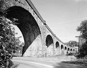 The Thomas Viaduct, a signature monument of Patapsco Valley State Park | |
| Country | United States |
|---|---|
| State | Maryland |
| Counties | Anne Arundel, Baltimore, Carroll, Howard |
| Elevation | 374 ft (114 m) [1] |
| Coordinates | 39°17′35″N 76°47′12″W / 39.29306°N 76.78667°WCoordinates: 39°17′35″N 76°47′12″W / 39.29306°N 76.78667°W [1] |
| Area | 14,340 acres (5,803 ha) [2] |
| Established | October 6, 1907 |
| Management | Maryland Department of Natural Resources |
| IUCN category | V - Protected Landscape/Seascape |
 Location in Maryland | |
| Website: Patapsco Valley State Park | |
Patapsco Valley State Park is a public recreation area extending along 32 miles (51 km) of the Patapsco River south and west of the city of Baltimore, Maryland.[3] The state park encompasses multiple developed areas on over 14,000 acres (5,700 ha) of land. In 2006, it was officially celebrated as Maryland's first state park and is managed by the Maryland Department of Natural Resources.[4]
History
- 20th century
Formation of the park started with provisions in the Forestry Act of 1906. The completion of Bloede's Dam in 1906 required the implementation of protections to prevent silting from nearby farm erosion. Patapsco Valley State Park was established as Patapsco State Forest Reserve in 1907 to protect the valley's forest and water resources.[5] The first 43 acres were donated by Russell Sage Foundation director John Mark Glenn (1858-1950) from his Hilton estate.[4] In 1912, Maryland delegate Carville Benson promoted expanding the Patapsco Forest Reserve as a park to support his suburban development initiatives.[6] As other sections along the river were added, Patapsco Valley State Park became one of the largest parks in Maryland.
In 1933, the Civilian Conservation Corps opened State Park Project 2 work camps 336 and 356 at the park. CCC workers created recreational facilities and performed tree plantings for erosion control and silt management around the dam from adjacent overworked farms.[7] Keeping the shores and hillsides vegetated minimized erosion, thus minimizing the amount of silt that could clog the turbines of Bloede's Dam which generated electricity for surrounding communities.
On May 15, 1941, the camp was converted to the nation's first Civilian Public Service conscientious objector camp, with 26 men and three women[8] required to serve for one year, a term that was extended as the United States entered World War II.[9]
- 21st century
In 2014, Howard County and Baltimore County[10] approved the Patapsco Heritage Greenway, Inc. management plan[11] for the Patapsco Heritage Area with includes a portion of the Patapsco Valley State Park.[12][13]
In 2015, 24.6 square miles which includes a portion of the Patapsco Valley State Park, was certified as the Maryland’s 13th Heritage Area by the Maryland Heritage Areas Authority. The Maryland Chapter of the Sierra Club opposed the project out of concern of additional development on the valuable land, of which the Maryland Department of Natural Resources would be the approving authority.[14]
Activities and amenities
The park's recreational opportunities include hiking, fishing, camping, canoeing, horseback riding, mountain biking, and picnicking. The Baltimore City Paper named the park as its "Best Place to Hike" in 2007.[15]
- Park areas
- McKeldin Area: The park's most western section features multi-use trails for horseback riding, mountain biking and hiking, a disc golf course, fishing at the confluence of the North and South branches of the Patapsco River, and the Rapids area on the South Branch.[16]
- Daniels Area: Once the site of a milltown called Daniels, the Daniels dam here backs up the Patapsco River providing smooth water for canoeing and kayaking, fishing, and swimming.[17]

- Hollofield Area: The park's center section features a 73-site campground, hiking trails, and shelters built by the CCC in the 1930s, plus a scenic overlook of the entire river valley.[18]
- Pickall Area: Picnic shelters and playgrounds.[19]
- Hilton Area: Located near Catonsville, the area has a small campground with mini-cabins, a nature center for children, and access to the Saw Mill Branch Trail and other trails.[20]
- Avalon/Glen Artney/Orange Grove Flour Mill Area: The area features many historic sites including the Thomas Viaduct, Bloede's Dam, the Old Gun Road Stone Arch Bridge, Orange Grove Flour Mill, and the Swinging Bridge. The Avalon Visitor Center is housed in a remnant of the milltown of the same name that once served the Avalon Nail and Iron Works.[21]
| Wikimedia Commons has media related to Avalon/Glen Artney/Orange Grove Area. |
- Swinging bridges
There are two swinging bridges that cross the Patapsco River. The first spans the Patapsco at Orange Grove, 1.6 miles (2.6 km) northwest of Avalon following the Park Road in Howard County beyond shelters 104 and 105. Prior suspension foot bridges at this location enabled residents of the Orange Grove mill community to cross the river to Baltimore County to work in the five-storey-high Orange Grove Flour Mill of the C.A. Gambrill Manufacturing Company that burned to the ground in 1905. Visitors can cross the bridge to discover the ruins of the mill site that extended from the railroad tracks to the Swinging Bridge abutment.[22]
A second swinging bridge opened November 4, 2006. It is located at the end of the Grist Mill Trail and crosses the Patapsco River to connect with Ilchester Road. This new bridge allows easy entry for residents living in Ellicott City and Catonsville for the first time since Hurricane Agnes struck in 1972.[4]
- Cascade Falls
Cascade Falls is located in the Orange Grove area of the park. It gently descends a 10–15-foot (3.0–4.6 m) face and can be reached by way of a marked trail at the last parking lot in the Orange Grove area.[23]
| Wikimedia Commons has media related to Cascade Falls. |
In popular culture
In 1999, final scenes of The Blair Witch Project were filmed in the Griggs House, a 200-year-old building located in the park near Granite, Maryland, that was subsequently demolished by the state despite film buffs' efforts to save it.[24][25][26]
See also
References
- 1 2 "Patapsco State Park". Geographic Names Information System. United States Geological Survey.
- ↑ "Fiscal Year 2016 DNR Owned Lands Acreage" (PDF). Maryland Department of Natural Resources. July 29, 2016. Retrieved November 13, 2016.
- ↑ "Patapsco Valley State Park". Maryland DNR. Retrieved November 18, 2014.
- 1 2 3 "Maryland's First State Park: Plaque Dedication". Maryland Department of Natural Resources. Retrieved November 13, 2016.
- ↑ MacKay, Bryan (2008). Baltimore Trails: A Guide for Hikers and Mountain Bikers. Johns Hopkins University Press. p. 4. ISBN 0801890705.
- ↑ Bailey, Robert F. (2006). Maryland's Forests and Parks: A Century of Progress. Arcadia Publishing. p. 40. ISBN 0738543519.
- ↑ "The Civilian Conservation Corps Part II: A Maryland Perspective". Maryland DNR. Retrieved November 13, 2013.
- ↑ Peter Brock, Thomas Paul Socknat, eds. (1999). Challenge to Mars: Essays on Pacifism from 1918 to 1945. University of Toronto Press. p. 312. ISBN 0802043712.
- ↑ Goossen, Rachel Waltner (1997). Women Against the Good War: Conscientious Objection and Gender. University of North Carolina Press. p. 20. ISBN 0807846724.
- ↑ "Patapsco River". Environmental Protection and Sustainability. Baltimore County, MD. Retrieved April 4, 2015.
- ↑ "PHG Draft Management Plan". Patapsco Heritage Greenway. Patapsco Heritage Greenway. Retrieved April 4, 2015.
- ↑ Loricchio, Lauren (March 26, 2014). "Organization creates plan to preserve Patapsco River Valley". The Baltimore Sun. Retrieved April 4, 2015.
- ↑ Yeager, Amanda (July 23, 2014). "In Patapsco Valley, two groups say they want what's best for state park". The Baltimore Sun. Retrieved November 18, 2014.
- ↑ Loricchio, Lauren (January 28, 2015). "Portion of Patapsco Valley becomes state's 13th certified heritage area". The Baltimore Sun. Retrieved April 4, 2015.
- ↑ "Best Place to Hike". Baltimore City Paper. September 19, 2007. Retrieved December 30, 2013.
- ↑ "Patapsco Valley State Park - McKeldin Area". Maryland DNR. Retrieved November 18, 2014.
- ↑ "Patapsco Valley State Park - Daniels Area". Maryland DNR. Retrieved November 18, 2014.
- ↑ "Patapsco Valley State Park - Hollofield Area". Maryland DNR. Retrieved November 18, 2014.
- ↑ "Patapsco Valley State Park - Pickall Area". Maryland DNR. Retrieved November 18, 2014.
- ↑ "Patapsco Valley State Park - Hilton Area". Maryland DNR. Retrieved November 18, 2014.
- ↑ "Patapsco Valley State Park - Avalon/Glen Artney/Orange Grove Areas". Maryland DNR. Retrieved November 18, 2014.
- ↑ "Patapsco Valley State Park History". Maryland DNR. Retrieved July 21, 2015.
- ↑ "Cascade Falls". The Waterfall Chase. Joshua Szulecki. Retrieved December 30, 2013.
- ↑ "The Blair Witch Project Filming Locations". IMDB. Retrieved 8 January 2014.
- ↑ Atwood, Liz (January 1, 2000). "Blair Witch works magic for doomed house". The Baltimore Sun.
- ↑ Gelbert, Doug (2002). Film and Television Locations. McFarland & Company. p. 103. ISBN 0786412933.
External links
| Wikimedia Commons has media related to Patapsco Valley State Park. |
- Patapsco Valley State Park Maryland Department of Natural Resources
 Geographic data related to Patapsco Valley State Park at OpenStreetMap