Kendall West, Florida
| West End, Florida | |
|---|---|
| Census-designated place (CDP) | |
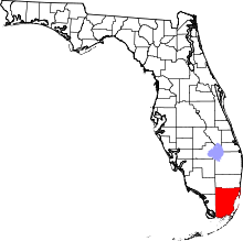
 Location in Miami-Dade County and the state of Florida | |
 U.S. Census Bureau map showing boundaries | |
| Coordinates: 25°42′20″N 80°26′26″W / 25.70556°N 80.44056°WCoordinates: 25°42′20″N 80°26′26″W / 25.70556°N 80.44056°W | |
| Country |
|
| State |
|
| County | Miami-Dade |
| Area | |
| • Total | 3.7 sq mi (9.5 km2) |
| • Land | 3.4 sq mi (8.8 km2) |
| • Water | 0.3 sq mi (0.7 km2) |
| Population (2000) | |
| • Total | 38,034 |
| • Density | 10,279.5/sq mi (4,003.6/km2) |
| Time zone | Eastern (EST) (UTC-5) |
| • Summer (DST) | EDT (UTC-4) |
| FIPS code | 12-36121[1] |
West End (Kendall Lakes West) is a census-designated place and an unincorporated community Miami suburb in Miami-Dade County, Florida, west of the Florida Turnpike. The population was 38,034 at the 2000 census. The ZIP codes serving the census area are 33193 and 33196.
Geography
West End is located at 25°42′20″N 80°26′26″W / 25.70556°N 80.44056°W (25.705499, -80.440526).[2]
According to the United States Census Bureau, the census area has a total area of 3.7 square miles (9.6 km2), of which, 3.4 square miles (8.8 km2) of it is land and 0.3 square miles (0.78 km2) of it (7.12%) is water.
Demographics
| Historical population | |||
|---|---|---|---|
| Census | Pop. | %± | |
| 1990 | 6,038 | — | |
| 2000 | 38,034 | 529.9% | |
| 2010 | 36,154 | −4.9% | |
| source:[3][4] | |||
As of the census[1] of 2000, there were 38,034 people, 11,759 households, and 9,807 families residing in the CDP. The population density was 11,218.6 people per square mile (4,331.9/km²). There were 12,229 housing units at an average density of 3,607.1/sq mi (1,392.8/km²). The racial makeup of the CDP was 83.37% White (15.3% were Non-Hispanic White,)[5] 4.23% African American, 0.19% Native American, 1.48% Asian, 0.03% Pacific Islander, 6.44% from other races, and 4.25% from two or more races. Hispanic or Latino of any race were 79.03% of the population.
There were 11,759 households out of which 49.5% had children under the age of 18 living with them, 58.8% were married couples living together, 18.5% had a female householder with no husband present, and 16.6% were non-families. 11.8% of all households were made up of individuals and 2.5% had someone living alone who was 65 years of age or older. The average household size was 3.23 and the average family size was 3.47.
In the census area, the population was spread out with 29.2% under the age of 18, 10.2% from 18 to 24, 34.9% from 25 to 44, 18.5% from 45 to 64, and 7.1% who were 65 years of age or older. The median age was 32 years. For every 100 females there were 89.7 males. For every 100 females age 18 and over, there were 84.7 males.
The median income for a household in the community was $38,715, and the median income for a family was $39,564. Males had a median income of $30,082 versus $23,695 for females. The per capita income for the CDP was $14,806. About 13.3% of families and 15.4% of the population were below the poverty line, including 18.4% of those under age 18 and 13.4% of those age 65 or over.
As of 2000, speakers of Spanish as a first language accounted for 84.44%% of residents, while English made up 13.48%, and both French Creole and Portuguese were the mother tongue for 0.47% of the population.[6]
See also
- West Kendall, a neighborhood within the census boundaries of Kendall.
- West End (Florida)
References
- 1 2 "American FactFinder". United States Census Bureau. Retrieved 2008-01-31.
- ↑ "US Gazetteer files: 2010, 2000, and 1990". United States Census Bureau. 2011-02-12. Retrieved 2011-04-23.
- ↑ "CENSUS OF POPULATION AND HOUSING (1790-2000)". U.S. Census Bureau. Retrieved 2010-07-30.
- ↑ Census area returned as Kendall Lakes West in 1990.
- ↑ "Demographics of Kendall West, FL". MuniNetGuide.com. Retrieved 2007-11-06.
- ↑ "MLA Data Center Results of West Kendall, FL". Modern Language Association. Retrieved 2007-11-06.