Riviera Beach, Florida
| Riviera Beach, Florida | |
|---|---|
| City | |
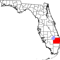
 Location of Riviera Beach in Palm Beach County, Florida | |
| Coordinates: 26°46′48″N 80°4′2″W / 26.78000°N 80.06722°WCoordinates: 26°46′48″N 80°4′2″W / 26.78000°N 80.06722°W | |
| Country | United States |
| State | Florida |
| County | Palm Beach |
| Government | |
| • Mayor | Thomas Masters (D)[1] |
| Area | |
| • Total | 9.8 sq mi (25.5 km2) |
| • Land | 8.3 sq mi (21.6 km2) |
| • Water | 1.5 sq mi (3.9 km2) |
| Elevation | 13 ft (4 m) |
| Population (2013) | |
| • Total | 33,369 |
| • Density | 3,585.3/sq mi (1,384.3/km2) |
| Time zone | Eastern (EST) (UTC-5) |
| • Summer (DST) | EDT (UTC-4) |
| Area code(s) | 561 |
| FIPS code | 12-60975[2] |
| GNIS feature ID | 0289758[3] |
| Website | Riviera Beach official website |
Riviera Beach is a city in Palm Beach County, Florida, United States, which was incorporated September 29, 1922. Due to the location of its eastern boundary lies, it is also the easternmost municipality in the South Florida metropolitan area. The population was 29,884 at the 2000 census. As of 2004, the population was estimated by the U.S. Census Bureau to be 32,522.[4]
Riviera Beach is predominantly an African American city and it is on the List of U.S. cities with African American majority populations. It is home to the Port of Palm Beach and a United States Coast Guard station, and has its own marina.[5][6] Riviera Beach is home to Blue Heron Bridge, one of the country's top rated beach dive sites.[7] Riviera Beach made news in 2015 when it renamed the stretch of Old Dixie Highway that runs inside the city limits as President Barack Obama Highway.[8][9] [8]
History
Riviera Beach was originally called Riviera, and under the latter name was platted in 1913.[10] It was named after the French Riviera.[11]
Geography
According to the United States Census Bureau, the city has a total area of 9.8 square miles (25 km2), of which 8.3 square miles (21 km2) is land and 1.5 square miles (3.9 km2) (15.33%) is water.
Demographics
| Historical population | |||
|---|---|---|---|
| Census | Pop. | %± | |
| 1930 | 811 | — | |
| 1940 | 1,981 | 144.3% | |
| 1950 | 4,065 | 105.2% | |
| 1960 | 13,046 | 220.9% | |
| 1970 | 21,401 | 64.0% | |
| 1980 | 26,489 | 23.8% | |
| 1990 | 27,639 | 4.3% | |
| 2000 | 29,884 | 8.1% | |
| 2010 | 32,488 | 8.7% | |
| Est. 2015 | 34,005 | [12] | 4.7% |
As of the census[2] of 2000, there were 29,884 people, 11,387 households, and 7,526 families residing in the city. The population density was 3,585.3 inhabitants per square mile (1,383.5/km²). There were 14,220 housing units at an average density of 1,706.0 per square mile (658.3/km²). The racial makeup of the city was 25.75% White (25.4% were Non-Hispanic White,)[14] 67.81% African American, 0.14% Native American, 0.99% Asian, 0.05% Pacific Islander, 1.10% from other races, and 2.14% from two or more races. Hispanic or Latino of any race were 4.51% of the population.
There were 11,387 households out of which 29.3% had children under the age of 18 living with them, 37.1% were married couples living together, 27.0% had a female householder with no husband present, and 29.3% were non-families. 22.3% of all households were made up of individuals and 6.1% had someone living alone who was 65 years of age or older. The average household size was 3.04 and the average family size was 4.62. In the city the population was spread out with 37.5% under the age of 18, 10.0% from 18 to 24, 27.1% from 25 to 44, 20.7% from 45 to 64, and 8.7% who were 65 years of age or older. The median age was 30 years. For every 100 females there were 107.5 males. For every 100 females age 18 and over, there were 105.6 males. The median income for a household in the city was $28,715, and the median income for a family was $26,756.
Males had a median income of $27,232 versus $22,410 for females. The per capita income for the city was $13,159. About 29.6% of families and 32.3% of the population were below the poverty line, including 35.1% of those under age 18 and 21.4% of those age 65 or over. As of 2000, those who solely spoke English at home accounted for 90.30% of all residents, while speakers of Spanish were 4.71%, French Creole 2.42%, and French speakers 0.95%.[15]
Education
- Suncoast High School
- Inlet Grove High School
- John F Kennedy Middle School
- West Riviera Elementary School
- Lincoln Elementary School
- Dr. Mary McLeod Bethune Elementary School
- Washington Elementary School
- Riviera Beach Preparatory Academy
Transportation
Riviera Beach is served by several bus routes operated by PalmTran.[16]
Notable people
- Anthony Carter - Michigan and NFL superstar, Pro Bowl wide receiver, was born and attended school in Riviera Beach.
- Devin Hester - NFL Pro Bowl and record-holding kick returner for Chicago Bears and Atlanta Falcons, was born and attended school in Riviera Beach.
- Elizabeth Jacobson - USAF, killed in Iraq War.
- Burt Reynolds - actor, moved to Riviera Beach in 1946 at the age of 10; his father, a police officer, was once the Riviera Beach Chief of Police.
- Willie Young - NFL defensive end for Chicago Bears, was born in Riviera Beach.
See also
References
- ↑ "February 2016 Voter Guide" (PDF). League of Women Voters of Palm Beach County. February 2016. Retrieved 12 April 2016.
Thomas A. Masters-D
- 1 2 "American FactFinder". United States Census Bureau. Retrieved 2008-01-31.
- ↑ "US Board on Geographic Names". United States Geological Survey. 2007-10-25. Retrieved 2008-01-31.
- ↑ Annual Estimates of the Population for Incorporated Places in Florida, Listed Alphabetically: April 1, 2000 to July 1, 2004; retrieved July 29, 2006.
- ↑ Riviera Beach Crime Report, cityrating.com; retrieved July 29, 2006.
- ↑ Riviera Beach struggles to overcome decades of divisiveness, palmbeachpost.com; retrieved July 29, 2006.
- ↑ "Blue Heron Bridge". Blue Heron Bridge: Diving + Snorkeling Blue Heron Bridge. SinkFloridaSink.com. Retrieved April 12, 2014.
- 1 2 "Old Dixie Highway renamed in honor of Obama in Riviera Beach". Sun Sentinel. 2015-12-17. Retrieved 2016-11-11.
- ↑ Izadi, Elahe (2015-12-19). "Old Dixie Highway renamed President Barack Obama Highway in Florida city". The Washington Post. Retrieved 2016-11-11.
- ↑ "Riviera and Riviera Beach". Palm Beach County Historical Society. Retrieved May 30, 2015.
- ↑ Kleinberg, Eliot (September 16, 1987). "A Town By Any Other Name". The Palm Beach Post. p. D7. Retrieved May 30, 2015.
- ↑ "Annual Estimates of the Resident Population for Incorporated Places: April 1, 2010 to July 1, 2015". Retrieved July 2, 2016.
- ↑ "Census of Population and Housing". Census.gov. Retrieved June 4, 2015.
- ↑ "Demographics of Riviera Beach, FL". MuniNetGuide.com. Retrieved 2007-11-13.
- ↑ "MLA Data Center Results of Riviera Beach, FL". Modern Language Association. Retrieved November 13, 2007.
- ↑ "Palm Tran Home". Pbcgov.com. Retrieved 2016-11-11.
External links
- Singer Island Civic Association website with news, area links, classifieds and live beach cams for locals and welcome visitors of Singer Island Florida
- Online version (made available for public use by the State Archives of Florida) of a 1939 WPA exhibit on the Conchs of Riviera Beach, Florida
- Riviera Beach, Florida Police Department