Oakland Park, Florida
| Oakland Park, Florida | |||||
|---|---|---|---|---|---|
| City | |||||
| City of Oakland Park | |||||
|
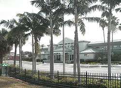
Oakland Park's City Hall in July 2009 | |||||
| |||||
| Motto: "Engaged·Inspired·United: A City on the Move"[1] | |||||
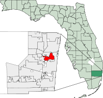 Location of Oakland Park in Broward County, Florida | |||||
| Coordinates: 26°10′35″N 80°08′40″W / 26.17639°N 80.14444°WCoordinates: 26°10′35″N 80°08′40″W / 26.17639°N 80.14444°W | |||||
| Country |
| ||||
| State |
| ||||
| County |
| ||||
| Settled (Colohatchee Settlement) | Late 1800's-Early 1900's[2][3][4] | ||||
| Incorporated (Town of Floranada) | November 25, 1925[5] | ||||
| Incorporated (City of Oakland Park) | June 19, 1929[5] | ||||
| Government | |||||
| • Type | Commission-Manager | ||||
| • Mayor | Tim Lonergan (D)[6] | ||||
| • Vice Mayor | John Adornato III | ||||
| • Commissioners | Sara Guevrekian, Jedidiah "Jed" Shank and Michael E. Carn | ||||
| • City Manager | David Hebert | ||||
| • Assistant City Manager | Ana Alvarez | ||||
| Area[7] | |||||
| • City | 8.1 sq mi (21.1 km2) | ||||
| • Land | 7.5 sq mi (19.3 km2) | ||||
| • Water | 0.7 sq mi (1.8 km2) | ||||
| Elevation | 9 ft (1 m) | ||||
| Population (2014) | |||||
| • City | 43,800 | ||||
| • Density | 5,545/sq mi (2,141.0/km2) | ||||
| • Metro | 5,564,635 | ||||
| Time zone | EST (UTC-5) | ||||
| • Summer (DST) | EDT (UTC-4) | ||||
| ZIP code | 33304-33309, 33311, 33334 | ||||
| Area code(s) | 754, 954 | ||||
| FIPS code | 12-50575[8] | ||||
| GNIS feature ID | 0288013[9] | ||||
| Website |
www | ||||

Oakland Park, officially the City of Oakland Park, is a city in Broward County, Florida, United States. As of the 2010 United States Census, the city's population was 41,363,[10] mainly due to annexation of North Andrews Gardens and Twin Lakes South. It is part of the Miami–Fort Lauderdale–Pompano Beach Metropolitan Statistical Area, which was home to 5,564,635 people at the 2010 census.
History
Originally named "Floranada" (a blend of Florida and Canada), the town was forced into bankruptcy after the hurricane of 1926. When the municipality reincorporated, residents chose to make it a city and voted for the name "Oakland Park." The original boundaries went from the Atlantic Ocean, west to what is now U.S. 441, and from the north fork of Middle River north to Cypress Creek Boulevard, but when the boundaries were reestablished, it was to approximately the west side of U.S. 1, west to Northeast 3rd Avenue and the north fork of Middle River north to what is now Prospect Road. Over time, it has expanded to its current boundaries, mainly due to acquiring a few other areas, such as recent annexations of previously unincorporated neighborhoods of Twin Lakes South and North Andrews Gardens.[11]
Geography
Oakland Park is located at 26°10′35″N 80°8′40″W / 26.17639°N 80.14444°W (26.176362, -80.144509).[12] According to the United States Census Bureau, the city has a total area of 8.1 square miles (21.1 km2), of which 7.5 square miles (19.3 km2) is land and 0.69 square miles (1.8 km2) (8.40%) is water.[10]
Oakland Park is bisected by the Florida East Coast Railway, which runs parallel to Dixie Highway through the city's downtown. The City of Oakland Park has put into place new zoning regulations intended to transform downtown Oakland Park into a mixed-use pedestrian community. One element of the proposal is the creation of a new commuter rail station on the FEC rail line.
Oakland Park borders the city of Wilton Manors, which is experiencing a tremendous amount of new development. Increased property prices in Wilton Manors have pushed up prices in Oakland Park and spurred interest in the city's downtown redevelopment plan.[13]
Demographics
| Historical population | |||
|---|---|---|---|
| Census | Pop. | %± | |
| 1930 | 463 | — | |
| 1940 | 815 | 76.0% | |
| 1950 | 1,295 | 58.9% | |
| 1960 | 5,331 | 311.7% | |
| 1970 | 16,261 | 205.0% | |
| 1980 | 22,944 | 41.1% | |
| 1990 | 26,326 | 14.7% | |
| 2000 | 30,966 | 17.6% | |
| 2010 | 41,363 | 33.6% | |
| Est. 2015 | 44,319 | [14] | 7.1% |
| Oakland Park Demographics | |||
|---|---|---|---|
| 2010 Census | Oakland Park | Broward County | Florida |
| Total population | 41,363 | 1,748,066 | 18,801,310 |
| Population, percent change, 2000 to 2010 | +33.6% | +7.7% | +17.6% |
| Population density | 5,545.1/sq mi | 1,444.9/sq mi | 350.6/sq mi |
| White or Caucasian (including White Hispanic) | 62.6% | 63.1% | 75.0% |
| (Non-Hispanic White or Caucasian) | 45.1% | 43.5% | 57.9% |
| Black or African-American | 25.6% | 26.7% | 16.0% |
| Hispanic or Latino (of any race) | 25.6% | 25.1% | 22.5% |
| Asian | 2.0% | 3.2% | 2.4% |
| Native American or Native Alaskan | 0.3% | 0.3% | 0.4% |
| Pacific Islander or Native Hawaiian | 0.1% | 0.1% | 0.1% |
| Two or more races (Multiracial) | 3.5% | 2.9% | 2.5% |
| Some Other Race | 6.3% | 3.7% | 3.6% |
As of 2010, there were 20,076 households out of which 12.8% were vacant. As of 2000, 24.5% had children under the age of 18 living with them, 32.3% were married couples living together, 13.3% had a female householder with no husband present, and 48.6% were non-families. 35.1% of all households were made up of individuals and 7.4% had someone living alone who was 65 years of age or older. The average household size was 2.26 and the average family size was 3.00.
In 2000, the city the population was spread out with 20.9% under the age of 18, 9.0% from 18 to 24, 38.7% from 25 to 44, 21.3% from 45 to 64, and 10.2% who were 65 years of age or older. The median age was 36 years. For every 100 females there were 109.1 males. For every 100 females age 18 and over, there were 109.8 males.
In 2000, the median income for a household in the city was $35,493, and the median income for a family was $38,571. Males had a median income of $30,269 versus $25,514 for females. The per capita income for the city was $18,873. About 13.3% of families and 16.5% of the population were below the poverty line, including 22.1% of those under age 18 and 11.3% of those age 65 or over.
As of 2000, English as a first language comprised 66.52%, while 18.16% spoke Spanish, 6.95% spoke French Creole as theirs, 3.32% spoke Portuguese, 1.99% spoke French, Italian was at 0.64%, and German as a mother tongue made up 0.52% of the population.[16]
As of 2000, Oakland Park was the fifteenth most Brazilian-populated area in the US (tied with several other areas) at 2.1%,[17] and it had the twenty-fifth highest percentage of Haitians in the US, with 7% of the population (tied with Ramapo, New York.)[18]
Also, as of 2000, the North Andrews Gardens section of Oakland Park is the sixty-third most Cuban-populated area in the US at 5.76%, while the rest of Oakland Park had the 113th highest percentage of Cubans with 2.03% of all residents.[19] The North Andrews Gardens section was also the thirty-third most Peruvian-populated area in the US, at 1.51% of the population,[20] as well as having the seventy-fourth highest percentage of Colombians in the US, at 2.03% of all residents.[21]
Neighborhoods
These are the neighborhoods and communities that are officially recognized by the City of Oakland Park.[22]
|
|
|
Government and infrastructure
The United States Postal Service operates post offices in Oakland Park, including the Oakland Park Post Office at 3350 NE 12th Avenue,[23] the Fort Lauderdale Main Post Office at 1900 West Oakland Park Boulevard,[24] the North Andrews Annex at 3400 North Andrews Avenue (closed),[25] and the North Ridge Annex at 4350 North Andrews Avenue (closed).[26]
Economy
The movie theater chain Muvico has its headquarters in Oakland Park.[27][28]
Also home to Oakland Park is the Funky Buddha Brewery, a facility that produces beers unique to the South Florida market, its most popular arguably being Hop Gun.[29]
Media
Oakland Park is a part of the Miami-Fort Lauderdale-Hollywood media market, which is the twelfth largest radio market[30] and the seventeenth largest television market[31] in the United States. Its primary daily newspapers are the South Florida Sun-Sentinel and The Miami Herald, and their Spanish language counterparts El Sentinel and El Nuevo Herald. In 2016, the City produced a new promotional video.
Education
The city is served by Broward County Public Schools.
Oakland Park Elementary School is a 1925 school building on the National Register of Historic Places.
References
- ↑ "City of Oakland Park, Florida Website". City of Oakland Park, Florida Website. Retrieved July 5, 2015.
- ↑ "Images of America: Oakland Park (pages 7-17)". By Anne Salle and the Oakland Park Historical Society. Retrieved 2015-07-05.
- ↑ "Wilton Manors Historical Society Historical Notes, July 2013: Colohatchee Train Station" (PDF). By Ron Ulm with Benjamin Little and the Wilton Manors Historical Society. Retrieved 2015-07-05.
- ↑ "Wilton Manors: From Farming Community to Urban Village (page 17)". By Benjamin B. Little and the Wilton Manors Historical Society. Retrieved 2015-07-05.
- 1 2 "Broward-by-the-Numbers (pages 3-5)" (PDF). www.broward.org. Retrieved 2015-07-05.
- ↑ "Mayor Tim Lonergan". City of Oakland Park, FL. Retrieved 11 April 2016.
Mayor Lonergan has been an active and dedicated member of the Oakland Park Volunteer Corps since 2008. He is also a member of: Oakland Park Democratic Club
- ↑ "Florida by Place. Population, Housing, Area, and Density: 2000". US Census Bureau. Archived from the original on October 13, 2007. Retrieved 2007-09-23.
- ↑ "American FactFinder". United States Census Bureau. Archived from the original on September 11, 2013. Retrieved 2008-01-31.
- ↑ "US Board on Geographic Names". United States Geological Survey. 2007-10-25. Retrieved 2008-01-31.
- 1 2 "Geographic Identifiers: 2010 Demographic Profile Data (G001): Oakland Park city, Florida". U.S. Census Bureau, American Factfinder. Retrieved October 22, 2013.
- ↑ "About Oakland Park: History". The City of Oakland Park. Retrieved 2015-01-02.
- ↑ "US Gazetteer files: 2010, 2000, and 1990". United States Census Bureau. 2011-02-12. Retrieved 2011-04-23.
- ↑ "Oakland Park Main Street". Oakland Park Main Street. Retrieved 2007-09-24.
- ↑ "Annual Estimates of the Resident Population for Incorporated Places: April 1, 2010 to July 1, 2015". Retrieved July 2, 2016.
- ↑ "Census of Population and Housing". Census.gov. Archived from the original on May 11, 2015. Retrieved June 4, 2015.
- ↑ "MLA Data Center Results for Oakland Park, FL". Modern Language Association. Retrieved 2007-09-24.
- ↑ "Ancestry Map of Brazilian Communities". Epodunk.com. Retrieved 2007-10-22.
- ↑ "Ancestry Map of Haitian Communities". Epodunk.com. Retrieved 2007-10-22.
- ↑ "Ancestry Map of Cuban Communities". Epodunk.com. Retrieved 2007-10-22.
- ↑ "Ancestry Map of Peruvian Communities". Epodunk.com. Retrieved 2007-10-22.
- ↑ "Ancestry Map of Colombian Communities". Epodunk.com. Retrieved 2007-10-22.
- ↑ "City of Oakland Park, Florida Neighborhood Map". oaklandparkfl.org. Retrieved 2015-07-05.
- ↑ "Post Office Location - OAKLAND PARK." United States Postal Service. Retrieved on May 6, 2009.
- ↑ "Post Office Location - FORT LAUDERDALE." United States Postal Service. Retrieved on May 6, 2009.
- ↑ "Post Office Location - NORTH ANDREWS ANNEX." United States Postal Service. Retrieved on May 6, 2009.
- ↑ "Post Office Location - NORTH RIDGE ANNEX." United States Postal Service. Retrieved on May 6, 2009.
- ↑ "Oakland Park city, Florida." U.S. Census Bureau. Retrieved on January 7, 2011.
- ↑ "Contact Us." Muvico. Retrieved on January 7, 2011. "Address: MUVICO THEATERS 3101 N. Federal Hwy. 6th Floor Fort Lauderdale, FL 33306-1042."
- ↑ "Welcome - Funky Buddha Brewery". funkybuddhabrewery.com.
- ↑ "Top 50 Radio Markets Ranked By Metro 12+ Population, Spring 2005". Northwestern University Media Management Center. Archived from the original on 2007-08-07. Retrieved 2007-09-24.
- ↑ "Top 50 TV markets ranked by households". Northwestern University Media Management Center. Archived from the original on 2007-08-07. Retrieved 2007-09-24.
External links
| Wikimedia Commons has media related to Oakland Park, Florida. |
- Official website
- Oakland Park at City-Data.com
Municipalities and communities of Broward County, Florida, United States | ||
|---|---|---|
| Cities |  | |
| Towns | ||
| Villages | ||
| CDPs | ||
| Unincorporated community | ||
| Indian reservations | ||
| Ghost town | ||