Iloilo


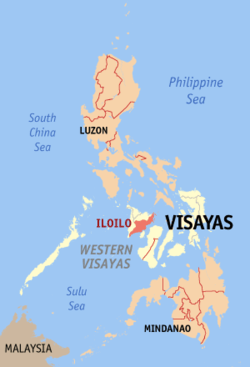
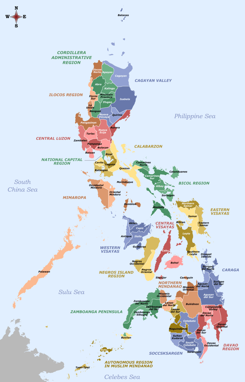
Iloilo (Hiligaynon: Kapuoran sang Iloilo; Karay-a: Probinsiya kang Iloilo; Filipino: Lalawigan ng Iloilo) is a province located in the region of Western Visayas in the Philippines. Iloilo occupies a major southeast portion of the island of Panay and is bordered by the province of Antique to the west, Capiz to the north, the Jintotolo Channel to the northeast, the Guimaras Strait to the east, and the Iloilo Strait and Panay Gulf to the southwest. Just off Iloilo's southeast coast is the island province of Guimaras, once part of Iloilo but now an independent province. Across the Panay Gulf and Guimaras Strait is Negros Occidental, occupying the northeastern half of the island of Negros.
Iloilo's capital is Iloilo City, though the city itself is independent and not governed by the provincial government of Iloilo. According to the 2015 census, the population of the province (excluding Iloilo City) is 1,936,423. If Iloilo City is included, the population is 2,361,042.
History
At the time of the Spanish conquest, writing was a new import and the use of organic medium such as leaf and bamboo, and no pre-Hispanic written accounts of Iloilo exist today. Oral history, in the form of recited epics, has survived to a small degree, with a few recordings made from the last known surviving binukots. But from these oral history and from writings from other sources, one can still glean Iloilo's prehispanic past.
The controversial origins of the people of Iloilo is said to be from the state of Pannai, a country occupying Sumatra. Pannai was a militant nation allied under the Sri-Vijaya Mandala that defended the conflict-ridden Strait of Malacca. The small kingdom repulsed any unlicensed Chinese, Indian or Arab navies that often warred in or pirated the straights of Malacca and for a small country, they were adept at taking down armadas larger than itself. They were successful in policing and defending the straights of Malacca for the Mandala of Sri-Vijaya until the Chola invasion of Srivijaya occurred, wherein a surprise attack from behind, originating from the occupied capital, rendered the militant-state of Pannai vulnerable from an unprotected assault from the back flank. The Chola invaders eventually destroyed the state of Pannai and its surviving soldiers, royals and scholars were said to have been secreted-out eastwards. In their 450 years of occupying Sumatra, they refused to be enslaved to Islam, Taoism or Hinduism but after the state's dissolution, the people who stayed behind in Pannai, themselves, have a legend wherein the high-borne scholars, soldiers and nobles of Pannai, "fled to other islands." [3]
At this juncture, Iloilo came into prominence, when the local settlement called Irong-Irong and was founded by Datu Paiburong, who presumably fled the fallen Sri Vijaya Mandala after he and his fellows within the new Mandala of Confederation of Madja-as, bought the island of Panay (Which they presumably named after the state of Pannai or the shortening of the Ati word, Ananipay) from the Negrito Chieftain, Marikudo. The Confederation of Madya-as eventually grew a powerful and strong naval presence that it rivaled the nearby states of the Rajahnate of Cebu, The Kingdom of Tondo and the Sultanate of Sulu when it came to wealth and prestige.


By 1512, this state had grown so powerful militarily and economically, their naval power regularly threatened Chinese Imperial shipping. So much so, that the Chuan-chou gazeeter specifically reported that the Pisheya (Bisaya) (Another term for people from Iloilo) consistently made devastating raids against the Empire's commerce [4]
Nevertheless, Spain eventually succeeded on conquering of the island of Panay when Spanish conquistador Miguel López de Legazpi moved his headquarters from the island of Cebu and creating the first Spanish settlement in the island in Ogtong in 1566. This is mainly due in part to the rivalries between the Bisaya and Moro, of which the former found an ally in Spanish against the latter. The Bisaya accepted alliances with Spain, to defend themselves against the enslaving Moros. To this end, Iloilo contributed troops in the Castille War against the Sultanate of Brunei. In 1581, the encomienda in Ogtong was moved to La Villa Rica de Arevalo, because of frequent coastal raids by the Dutch privateers. Furthermore, an attack in the year 1600 (Part of the Spanish–Moro conflict) where there was a large Muslim armada to destroy Iloilo City, led by two Moros named Sirungan and Salikala who lead the Muslim force of 70 ships and 4,000 warriors that had raided and attacked several Visayan islands in order to abduct slaves to sell to their allies in the Sultanate of Demak and the Sultanate of Malacca, eventually caused the move of the city center further on to the mouth of the Irong-Irong river founding what is now Iloilo City and constructing Fort San Pedro to defend it in 1616.[5] Nevertheless, when the 4,000 Moros led by Sirungan and Salikala tried to attack Iloilo City they were repulsed with heavy losses in Arevalo, Iloilo by a force of 1,000 Hiligaynon warriors and 70 Spanish arquebusiers under the command of Juan García de Sierra, who died in battle.[6]
Soon, the area itself began to prosper, due to its successful textile and sugar industry. As a result, it received Chinese immigrants from the west (that worked for its trades) and Latinos from the ports of Mexico in the east (to man its military installations). And over time Iloilo grew to be the most important province outside Manila. The City of Iloilo by virtue of a Royal Decree of 1896 was given the honor of having a coat of arms with the Inscription: "La Muy Leal y Noble Ciudad de Iloilo (The Most Loyal and Noble City) in reward for its loyalty to Spain during the Philippine uprising.
During the American period, Iloilo then became a home to many firsts: including the first department stores and cinemas in the country. Nevertheless, Iloilo experienced a fall from grace after it was severely devastated in World War II and then had a decline during the 1950s-2000s. In part due to the great Iloilo fire which ruined the economy and the slow death of the sugar and textile industries that eventually some prominent families (Iloilo then, had the highest concentration of millionaires outside Manila) to abandon the city to go to other areas such as Bacolod, Cebu and Manila. Still, the large middle-class populace of Iloilo and its agri-business sector has managed to maintain the province despite the exodus of some of its prominent families.
Geography

Iloilo covers a total area of 5,000.83 square kilometres (1,930.83 sq mi)[7] occupying the central and eastern section of Panay island in the Western Visayas region. The province is bordered by province of Antique to the west, Capiz to the north, the Jintotolo Channel to the northeast, the Guimaras Strait to the east, and the Iloilo Strait and Panay Gulf to the southwest.
The province is divided into two distinct geographic regions; the highlands of the Madia-as on the western border and the lowland plains which account for a larger portion of the province. Small islands east of its northernmost tip also dot the Visayan Sea - of these, Pan de Azucar and Sicogon are well-known.
Expansive fishponds and mangrove wetlands are found along the coasts and rivers of Oton, Iloilo City, Leganes, Zarraga, Dumangas, Barotac Nuevo, Anilao, Banate, Barotac Viejo, Ajuy, Balasan, and Carles.
Administrative divisions
Iloilo consists of 42 municipalities, one component city, and one highly urbanized city.
- † Provincial capital and highly urbanized city
- ∗ Component city
- Municipality
| |||||||||||||||||||||||||||||||||||||||||||||||||||||||||||||||||||||||||||||||||||||||||||||||||||||||||||||||||||||||||||||||||||||||||||||||||||||||||||||||||||||||||||||||||||||||||||||||||||||||||||||||||||||||||||||||||||||||||||||||||||||||||||||||||||||||||||||||||||||||||||||||||||||||||||||||||||||||||||||||||||||||||||||||||||||||||||||||||||||||||||||||||||||||||||||||||||||||||||||||||||||||||||||||||||||||||||||||||||||||||||||||||||||||||||||||||||||||||||||||||||||||||||||||||||||||||||||||||||||||||||||||||||||||||||||||||||||||||||||||||||||||||||||||||||||||||||||||||||||||||||||||||||||||||
Climate
| Climate data for Iloilo, Philippines — NOAA Station Id: PH98637 | |||||||||||||
|---|---|---|---|---|---|---|---|---|---|---|---|---|---|
| Month | Jan | Feb | Mar | Apr | May | Jun | Jul | Aug | Sep | Oct | Nov | Dec | Year |
| Average high °C (°F) | 29.7 (85.5) |
30.2 (86.4) |
31.7 (89.1) |
33.1 (91.6) |
33.1 (91.6) |
31.6 (88.9) |
30.7 (87.3) |
30.4 (86.7) |
30.8 (87.4) |
31.1 (88) |
30.9 (87.6) |
30.2 (86.4) |
31.12 (88.02) |
| Daily mean °C (°F) | 26.1 (79) |
26.5 (79.7) |
27.6 (81.7) |
28.9 (84) |
29.1 (84.4) |
28.1 (82.6) |
27.6 (81.7) |
27.5 (81.5) |
27.6 (81.7) |
27.7 (81.9) |
27.5 (81.5) |
26.8 (80.2) |
27.59 (81.66) |
| Average low °C (°F) | 22.7 (72.9) |
22.7 (72.9) |
23.5 (74.3) |
24.6 (76.3) |
25.1 (77.2) |
24.7 (76.5) |
24.4 (75.9) |
24.5 (76.1) |
24.4 (75.9) |
24.2 (75.6) |
24.0 (75.2) |
23.4 (74.1) |
24.02 (75.24) |
| Average rainfall mm (inches) | 39.9 (1.571) |
19.1 (0.752) |
27.1 (1.067) |
47.7 (1.878) |
117.9 (4.642) |
255.2 (10.047) |
313.2 (12.331) |
363.7 (14.319) |
266.8 (10.504) |
264.1 (10.398) |
174.8 (6.882) |
64.2 (2.528) |
1,953.7 (76.917) |
| Average relative humidity (%) | 82 | 80 | 75 | 73 | 77 | 82 | 85 | 85 | 85 | 84 | 84 | 83 | 81.25 |
| Source: "Climate (Average Weather) Data". Climate-Charts.com. Retrieved March 13, 2011. | |||||||||||||
Demographics
| Population census of Iloilo | ||
|---|---|---|
| Year | Pop. | ±% p.a. |
| 1990 | 1,337,981 | — |
| 1995 | 1,415,022 | +1.05% |
| 2000 | 1,559,182 | +2.10% |
| 2007 | 1,691,878 | +1.13% |
| 2010 | 1,805,576 | +2.40% |
| 2015 | 1,936,423 | +1.34% |
| (Excluding Iloilo City) Source: National Statistics Office[2][8][8] | ||
The population of Iloilo in the 2015 census was 1,936,423 people,[2] with a density of 390 inhabitants per square kilometre or 1,000 inhabitants per square mile. If the highly urbanized city of Iloilo is included for geographical purposes, the province's total population is 2,361,042 people, with a density of 465/km2 (1,204/sq mi).
People from Iloilo are called Ilonggos. There are three local languages spoken in the province: Hiligaynon (Ilonggo), Kinaray-a and Capiznon. Hiligaynon and dialects/variants of it are spoken in Iloilo City and a few towns of the province. Spanish is strictly a local language, at least in a historical way with the number of natural Spanish speakers strongly declining after WWII, and due to this, there are today many Ilonggos who do not consider it a local language.
Language

Hiligaynon (sometimes referred to as Ilonggo) is an Austronesian language spoken in Western Visayas in the Philippines. Hiligaynon is concentrated in the city of Iloilo and surrounding areas, as well as the northeastern portion of the province,[10] the northern portion of Guimaras and the western side of Negros Island Region, mainly in the province of Negros Occidental, as well as the provinces of South Cotabato, Sultan Kudarat and North Cotabato in Mindanao. It is also spoken in the other provinces in Panay, such as Capiz, Antique and Aklan, as well as in some parts of Maguindanao municipalities of Datu Paglas, Buluan and Mangudadatu as well. It is also spoken as a second language by Kinaray-a speakers in Antique, Aklanon/Malaynon speakers in Aklan, Cebuano speakers in Negros Oriental, and Capiznon speakers in Capiz. There are approximately more than 7,000,000 people in and outside the Philippines who are native speakers of Hiligaynon, and an additional 4,000,000 who are capable of speaking it with a substantial degree of proficiency.
The language is referred to as Ilonggo in Negros Occidental and in Iloilo. More precisely, Ilonggo is an ethnolinguistic group referring to the people living in Panay and the culture associated with the people speaking Hiligaynon. The boundaries of the dialect called Ilonggo and that called Hiligaynon are unclear. The disagreement of where what name is correct extends to Philippine language specialists and native laymen.
Religion
Iloilo is Catholic predominated province comprising about 80% of the population. Protestant churches also exist such as members of Philippine Independent Church or Aglipayan Church with 15% of the population, Baptist, Presbyterian, Methodist, Adventist, and other Evangelical Christians; There are also non Protestant and other Christian sects such as Iglesia Ni Cristo, Church of Christ of Latter day Saints (Mormon) and Jehovah's Witnesses while non Christians are usually represented by Muslims, and to a lesser extent, Buddhists and Hindus.
Culture
Spanish architecture can be seen in old buildings in downtown Iloilo. Ancient Indonesians and Malaysians, and later Chinese and Japanese merchants were trading with the Ilonggos long before the Spaniards came. The ruling Spanish government encouraged these foreign merchants to trade in Iloilo but they were not given privileges like ownership of land. Foreign merchants and Spaniards intermarried with the locals, and the Mestizo class was eventually born from their union. The Mestizo offsprings of the local nobilities later emerged as the ruling class of the Ilonggos (see Principalía).
The town's fiesta is one of the most important events for Ilonggos. Almost every town (municipality) in Iloilo has a fiesta and festival celebrated annually.
Iloilo is also home to two of the nation's cultural minorities the Sulod-Bukidnon and the Ati.
Government
- Governor: Arthur D. Defensor, Sr.
- Vice Governor: Christine S. Garin
|
|
 The Old Capitol building of the Province of Iloilo |
- PCL President: Paolo M. Guanco
- ABC President:
- 1st District: Oscar S. Garin, Jr.
- 2nd District: Arcadio H. Gorriceta
- 3rd District: Arthur D. Defensor, Jr.
- 4th District: Hernan Biron, Jr.
- 5th District: Niel C. Tupas, Jr.
Economy
Iloilo's economy is vibrant, because of good political will and the cooperation of the Ilonggos. Iloilo's "economic boom" made thousands of jobs, and made the province one of the most competitive in the country. Iloilo City is the center for real estate, accommodation, medical centers, education, shopping centers, business centers, IT/BPO centers and many more. Iloilo's Northern part consists of a strong fishing industry and a booming tourism industry. It is near the Visayan Sea which makes the province one of the leading areas in fisheries in the country. The Central part is an agri-industrial center producing a wide array of agricultural products such as corn, rice, bananas, sugar, and pineapples among others as well as high-end crops in the Bucari Area in Leon and in the highlands of Alimodian, inland resorts and trekking sites. The sugar industries is centered in Passi City and its neighboring towns like Lambunao, Duenas, San Enrique, and Binggawan. Southern Iloilo's economy is mostly based on tourism because of the century-old churches and colonized buildings and its beaches and marine reserves especially in Guimbal, Miagao, and San Joaquin towns.
Infrastructure
Iloilo International Airport
The airport serves the Province of Iloilo, including its capital city, Iloilo City, the regional center of the Western Visayas region in the Philippines. It opened its doors to commercial traffic on June 14, 2007 after a decade of planning and construction, replacing the old Iloilo Airport in Mandurriao, Iloilo City and inherited its IATA and ICAO airport codes. It is the fourth-busiest airport in the Philippines, from its predecessor. It is the first airport in both Western Visayas and the island of Panay to be built to international standards, and one of the four airports in the region planned to be an international gateway. It is one of the 2 international airports in Western Visayas, the other one being Kalibo International Airport.
Iloilo Port Complex
The Port of Iloilo, considered the leader of trade and a commercial hub for Western Visayas is also one of the safest natural seaports in the Philippines. The Iloilo Commercial Port Complex is located on 20.8 hectares of reclaimed land. It includes 11,400 sq. meters of open space for operations, supplemented by an area of 97,000 sq. meters, a crane, rails of 348 lineal meters; roll-on-roll-off support; a 7,800 container freight stations; and a 720 sq. meter passenger shed. The port complex is ideal for ships plying international routes having a berth length of 400 meters, a width of 26.26 meters and a berthing depth of 10.50 meters.
A number of shipping companies use the Port of Iloilo, including Lorenzo Shipping Corporation, 2GO, Amigo Shipping Company, New Panay Shipping Company, Sulpicio Lines, and Trans-Asia Shipping Lines Inc. Fast ferries serve Iloilo-Bacolod routes eight times daily. 2GO inter-island, overnight ferries serve longer routes, going to Manila, Bacolod, Cebu, Zamboanga and Cagayan de Oro City. Pumpboat ferries cross the Iloilo Strait to Guimaras constantly during the day and on special trips at night.
Roll-on/roll-off ferry service, known as RO-RO, is available between Iloilo City and Guimaras, but the ro-ro to Negros is available from Dumangas, Iloilo including ro-ro from Iloilo to Palawan.
It is ranked third in terms of ship calls at 11,853, fourth in cargo throughout at 491,719 million metric tons and fourth in passenger traffic at 2.4 million annually.
Accessibility
Iloilo is one of the most accessible provinces in the Philippines. Iloilo can be reached by plane on regular commercial international flights from Hong Kong and Singapore to the Iloilo International Airport. Direct domestic flights connect Iloilo to major cities in the Philippines including Manila, Cebu, Davao, General Santos, Puerto Princesa, and Cagayan de Oro. Direct ferry routes and roll-on roll-off connections on the Philippines’ nautical highway are also available between Iloilo and all major cities in the country.
By plane, travel time to the Iloilo takes around 1 hour from Manila, 30 minutes from Cebu, 2 hours and 30 minutes from Hong Kong, and 3 hours and 30 minutes from Singapore. By direct ferry, Iloilo is approximately 1.5 hours away from Bacolod, and 15 minutes away from Guimaras. By land, Iloilo is around 4–5 hours away from Boracay, 3 hours away from Kalibo, and 2 hours away from Roxas City.
Iloilo transportation gateways
Iloilo International Airport – The Iloilo International Airport is the primary gateway to Iloilo. It serves regularly scheduled direct domestic flights to Iloilo from major Philippine airlines including Manila, Cebu, Davao, General Santos, Puerto Princesa, and Cagayan de Oro. The airport also serves international flights from Iloilo to Hong Kong and Singapore. Flights to Iloilo are served by Cebu Pacific, Philippine Airlines, PAL Express, and TigerAir. The Iloilo Airport is located approximately 19 kilometers or 20 minutes away by taxi from Iloilo City.
Iloilo Seaports – Ferries in Iloilo depart and arrive at various seaports in Iloilo City and Iloilo Province depending on the route and vessel type. (1) Ferry terminals along the Iloilo River in Lapuz district, Iloilo City serves fastcraft ferries from Bacolod, RORO ferries from Guimaras, and ferries from Palawan. (2) The Iloilo Domestic Port in Fort San Pedro, Iloilo City Proper serves shipping companies with routes from Manila, Cebu, Cagayan de Oro, and Zamboanga.[11]
Tourism


As a leading province during the Spanish Colonial Era, the province of Iloilo is widely known for its beautiful old world architecture similar to that of Latin American Countries. Spanish colonial Churches are amongst the well-known tourist sites in the province. Some natural sites are also in here as well as mixed-use parks that sprawl around the province.
Miag-ao Church. A World Heritage Site. The Aztec-Baroque inspired church with Filipino botanicals used to carved on the facade. It is known for its intricate facade and pyramidal bell towers. The church was used as a fortress during the olden days. It is a massive structure built of yellowish Limestones.
Molo Church. The Gothic Renaissance Church of Molo was used as a watch tower to warn the people if there are any attackers on the shore of Iloilo City. It is a fine coral stone church with Classical and Gothic details. It is also known as the feminist church because of the beautiful female saints lining inside the church.
Cabatuan Church. This Neoclassic Church, known to be the most massive Hispanic structure in Iloilo is built of red bricks. It is believed to be the largest red brick structure in the Visayas and it was given the title "Model of Temples" by the 'El Eco de Panay'. The Cabatuan Church is known to be the only extant Spanish colonial church with three facades.
San Jose Church. The beautiful church in front of plaza Libertad is considered the most historic amongst the churches in Iloilo City. It is a Byzantine-Neoclassic Church planned to look like the Spanish Church of Valencia del Cid. The Church is known for its collection of priceless Catholic treasures.
Passi City Church. This is considered a militaristic church in that it was planned as a ‘fortress church’ and the proof of this can be seen in the massive buttresses which support the front and back walls of the church. The church was built to replace churches that had been destroyed by an earthquake in 1612 and subsequent churches that had been destroyed by fires.
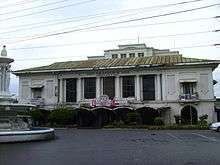
Old Capitol building of the Province of Iloilo. A National Historical Site. The building was built with wood stone during the Spanish colonization. It served as the capitol when the civil government of Iloilo was founded in 1901. The National Historical Institute (NHI) formally recognized the Old Capitol as a historical landmark through a marker installed on its walls on April 11, 2010.[12]
Bucari Area. Bucari Area is an area with mountainous terrain situated in the highlands of Leon and Alimodian. It is known as the "Summer Capital of Iloilo" and declared as a special economic zone for tourism and ecological enterprise due to its cool climate, topography, highland attractions and scenery.
Bulabog Putian National Park. Bulabog Puti-an National Park is a protected rain forest area known for being a living museum of flora and fauna. Hundreds of local and foreign tourists visit the 847 eco-tourism park to immerse in the area’s natural attractions such as its various forms of wildlife and more than 30 caves. It is located within the municipalities of San Enrique and Dingle.[13]
Islas de Gigantes. The Islas de Gigantes is an island group found in the offshores of the municipality of Carles. The place is known for its numerous caves, white sand beaches, emerald-like shores and lagoon, and rock formations.
Santa Barbara Church. The Santa Barbara Parish Church and Convent is considered to be the "Cradle of Independence" in Panay and in the Visayas. In 1991, the National Historical Commission of the Philippines declared Santa Barbara Church and Convent as a National Landmark. The church was the site where General Martin Delgado of the Visayan Revolutionary Government started the junta that resulted to the first Cry of Revolution against the Spaniards outside Luzon. It was also used as the general headquarters and military hospital of the revolutionary forces.
Calle Real Heritage District. Calle Real, or the J.M. Basa St. In Iloilo City, is once the shopping and entertainment center of the city during the Spainsh and American period. It houses numerous old colonized buildings.
Iloilo River Esplanade. The Esplanade is Iloilo City's newest hub for dining, leisure and recreation. Poised to be one of the longest linear park in the country.
Iloilo Golf and Country Club. The Iloilo Golf Course and Country Club is the oldest golf course in South East Asia. It all began in the 1850s when the British, led by Iloilo-based Vice Consul Nicholas Loney known today as the “Father of the Philippine Sugar Industry."
Universities and colleges
- ABBA Institute of Technology, Iloilo City
- ABE International Business College - Iloilo Campus
- AMA Computer University, Iloilo City
- Cabalum Western College, Iloilo City
- Central Philippine University, Iloilo City
- Colegio de San Jose, Iloilo City
- Colegio del Sagrado Corazon de Jesus, Iloilo City
- De Paul College, Iloilo City
- Dominican College of Iloilo, Zarraga, Iloilo
- Hua Siong College of Iloilo, Iznart Street, Iloilo City
- Iloilo City Community College,Iloilo City
- Iloilo Doctor's College, Iloilo City
- Iloilo Technical College, Iloilo City
- Interface Computer College, Iloilo City
- Iloilo Scholastic Academy, Iloilo City
- ISCOF/Iloilo State University of Science and Technology (ISUST)-Dumangas Campus
- ISCOF/ISUST - Main Campus, Tiwi Barotac Nuevo, Iloilo
- ISCOF/ISUST-Barotac Nuevo Polytechnic Institute Barotac Nuevo Campus
- ISCOF/ISUST-Dingle Agricultural College Dingle Campus
- ISCOF/ISUST-San Enrique Polytechnic College San Enrique Campus
- John B. Lacson Foundation Maritime University - Molo Campus, Molo, Iloilo City
- John B. Lacson Foundation Maritime University - Villa Arevalo Campus, Villa Arevalo, Iloilo City
- Leon Ganzon Polythechnic College, Balasan, Iloilo
- New Lucena Polytechnic College-New Lucena
- NIPSC Laboratory High School - West Campus, Estancia, Iloilo
- NIPSC - Ajuy Campus
- NIPSC - Barotac Viejo Campus
- NIPSC - Batad Campus
- NIPSC - Concepcion (CPC)
- NIPSC - Lemery Campus
- NIPSC - Sara Campus
- Northern Iloilo Polytechnic State College (Main) Estancia, Iloilo
- Passi City College, Passi City, Iloilo
- St. Paul's University, Iloilo City
- St. Therese – MTC colleges La Fiesta Site, Molo, Iloilo City
- St. Therese – MTC colleges Magdalo Site, La Paz, Iloilo City
- St. Therese – MTC colleges Tigbauan Site, Tigbauan, Iloilo
- St. Vincent College of Science and Technology, Leganes, Iloilo
- STI College, Iloilo City
- University of Iloilo - PHINMA Education Network
- University of Iloilo, Iloilo City
- University of San Agustin, Iloilo City
- University of the Philippines Visayas Iloilo City Campus, Iloilo City
- University of the Philippines Visayas Miag-ao Campus (UPV Main Campus), Miag-ao, Iloilo
- West Visayas State University Main Campus, Iloilo City
- Western Institute of Technology, Iloilo City
- Western Visayas College of Science and Technology Main Campus, Iloilo City
- WVCST-Don Jose Sustiguer Monfort Memorial National College, Barotac Nuevo, Iloilo
- WVCST-Leon National College of Agriculture, Leon, Iloilo
- WVCST-Purification Dolar Monfort College, Dumangas, Iloilo
- WVCST-Southern Iloilo Polytechnic College, Miag-ao, Iloilo
- WVSU-Calinog Campus, Calinog, Iloilo
- WVSU-Janiuay Campus, Janiuay, Iloilo
- WVSU-College of Agriculture and Forestry Campus, Lambunao, Iloilo
- WVSU-Lambunao East Campus, Lambunao, Iloilo
- WVSU-Pototan Campus, Pototan, Iloilo
School
- SPED-Integrated School for Exceptional Children
Sports
Stallion F.C. is an association football club founded in Barotac Nuevo. The club is affiliated with the Iloilo Football Association and currently playing in Division 1 of the United Football League.
Media
Iloilo City is home to regional television stations of GMA Network (GMA TV6 & GMA News TV 28), TV5 (UHF 36 & AksyonTV 46), Solar channels (9TV TV-4) ETC UHF 32 & 2nd Avenue UHF 24), (BEAM UHF 26) and ABS-CBN (ABS-CBN TV10, ABS-CBN Sports+Action (UHF 38)).
Notable Ilonggos
References
- ↑ "List of Provinces". PSGC Interactive. Makati City, Philippines: National Statistical Coordination Board. Archived from the original on January 21, 2013. Retrieved 11 February 2013.
- 1 2 3 4 "Region VI (WESTERN VISAYAS)". Census of Population (2015): Total Population by Province, City, Municipality and Barangay (Report). PSA. Retrieved 20 June 2016.
- ↑ Francisco Colin, S.J.; Madrid, published in 1663 , from his Labor evangélica
- ↑ Chuan-chou Fu-chi (Ch.10) Year 1512
- ↑ http://ilongo.weebly.com/iloilo-history-part-2.html
- ↑ Philippines: A Unique Nation By Dr. Sonia M. Zaide (2015) p. 150. [All Nations Publishing Co., Inc.]
- 1 2 3 "Province: Iloilo". PSGC Interactive. Quezon City, Philippines: Philippine Statistics Authority. Retrieved 8 January 2016.
- 1 2 3 "Region VI (WESTERN VISAYAS)". Census of Population and Housing (2010): Total Population by Province, City, Municipality and Barangay (Report). NSO. Retrieved 29 June 2016.
- ↑ Table 5. Household Population by Ethnicity and Sex: Iloilo, 2000
- ↑ and http://ilongo.weebly.com/languages-of-iloilo.html
- ↑ http://www.exploreiloilo.com/guide/iloilo-transportation/
- ↑ "Old Iloilo capitol now a national historical site". Philippine Information Agency. 13 April 2010. Archived from the original on October 2, 2011. Retrieved 16 April 2010.
- ↑
External links
-
 Media related to Iloilo at Wikimedia Commons
 -
 Iloilo (province) travel guide from Wikivoyage
 -
 Geographic data related to Iloilo at OpenStreetMap
 - Iloilo Travel Website
- Republic of the Philippines: Official website of the Provincial Government of Iloilo
- Philippine Standard Geographic Code
 |
Capiz | | ||
| Antique | |
Visayan Sea | ||
| ||||
| | ||||
| Iloilo Strait, Guimaras Strait Guimaras / Negros Occidental |
Iloilo (capital) | |
| Municipalities |
|
| Component city | |
| Highly urbanized city |
|
| |||||||||||||||||||||||||||||||||||||||||||||||||||||||||||||||||||||||||||||||||||||||||||||||||||||||||||||||||||||||||||||||||||||||||||||||||||||||||||||||||