San Enrique, Iloilo
| San Enrique Banwa kang San Enrique (Kinaray-a) Banwa sang San Enrique (Hiligaynon) Bayan ng San Enrique (Tagalog) | ||
|---|---|---|
| Municipality | ||
|
San Enrique Municipal Hall | ||
| ||
| Motto: Salus Populi Est Suprema Lex | ||
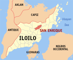 Map of Iloilo with San Enrique highlighted | ||
.svg.png) San Enrique Location within the Philippines | ||
| Coordinates: 11°04′N 122°39′E / 11.067°N 122.650°ECoordinates: 11°04′N 122°39′E / 11.067°N 122.650°E | ||
| Country | Philippines | |
| Region | Western Visayas (Region VI) | |
| Province | Iloilo | |
| Legislative district | 4th district of Iloilo | |
| Established | July 12, 1975 | |
| Barangays | 28 | |
| Government[1] | ||
| • Mayor | Rosario Mediatrix P. Fernandez | |
| • Vice Mayor | Ernesto P. Palomado | |
| Area[2] | ||
| • Total | 110.28 km2 (42.58 sq mi) | |
| Population (2010)[3] | ||
| • Total | 32,422 | |
| • Density | 294.0/km2 (761/sq mi) | |
| Time zone | PST (UTC+8) | |
| ZIP code | 5036 | |
| Dialing code | 33 | |
| Website |
www | |


San Enrique is a third class municipality in the province of Iloilo, Philippines. This town is located 54 kilometres (34 mi) from the provincial capital, Iloilo City. According to the 2010 census, it has a population of 32,422 people.[3]
Geography
Land use
Out of the total land area of 8,772 hectares; 7572 hectares is devoted to Agriculture; 33.34 hectares in Industrial; 12 hectares in Commercial; 86 hectares in residential; 25 hectares in Institutional and 1,043.66 hectares in forest, rivers, marsh and swamps.
Topography
There are six mountains range that landmark the topography of this municipality:
- Mt. Cañapasan
- Mt. Bayoso
- Mt. Gepiz
- Mt. Cararapan
- Mt. Cabas-an
- Mt. Puti-an
Standing on their own right, the queen of these mountains is Mount Cañapasan, which is noted for its panoramic surrounding area. Its highest skyline makes vertical lift of 569 meters sea level. Second highest mountain is Mt. Bayoso with 405 meters above sea level. Located in the eastern part of the Poblacion, the grandeur and splendor of its crest is the seat of the towering RCPI, SMART, PLDT and other relay stations.
Besides from the small mountain ranges mentioned above, hilly to rolling is the several slope of the land. With slightly rolling and marginal flat land that blighted its landscape, this is utilized for lowland farming.
Soil types
Generally, the soil type distribution in this area regardless of the land classification is clay and loam. This dominant in any topographic area.
Barangays
San Enrique is politically subdivided into 28 barangays.[2]
- Abaca
- Asisig
- Bantayan
- Braulan
- Cabugao Nuevo
- Cabugao Viejo
- Camiri
- Compo
- Catan-Agan
- Cubay
- Dacal
- Dumiles
- Garita
- Gines Nuevo
- Imbang Pequeño
- Imbesad-an
- Iprog
- Lip-ac
- Madarag
- Mapili
- Paga
- Palje
- Poblacion Ilawod
- Poblacion Ilaya
- Quinolpan
- Rumagayray
- San Antonio
- Tambunac
History
Early San Enriquenhons
Early inhabitants of San Enrique may be traced back to the tribes of those great Datus who had move up the river of Jalaud and settled on promontory they called "Bontoc". Following their customs and united by the bonds of kinship they built a community. Out of the flourishing settlement later rosegreat men like Manuel Paez, Modesto Palabrica and Apolinario Palabrica, who had earlier become Capitanes of the mother town of Passi. The names of Sanriago Pama, AugustoPalencia, Gregorio Aguilar, Bartolo Garrido, Cipriano Gonzales, Vicente Quianzon, and others surnamed Palabrica and Paez, had been elected to the position of Capitanes of Tenientes.
During an exploration talk held at the house of his aunt, Maura Ponte in Barangay Camiri, Jesus Prudente and his closest friends stressed the need to launch a movement aimed at separating San Enrique fromPassi. This was followed by a core group meeting at the old municipal building.In the presence of Ernesto Palabrica, Jose Lacsao, Crispin Lademora and Rodrigo Ponte, he laid down the mechanics for the reconstitution of the town into a separate political entity.
At the Assembly meeting called on November 25, 1956, a big crowd clustered in the market place at the corner of Palabrica and Manolo street. In his stirring speech Dr. Zosimo Palencia, the no. 1 councilor of Passi assured them of his wholehearted support. Other impassioned speakers were Exequiel Garrido, Jesus Paclibar, Juan Ayupan, Ernesto Palabrica, Genaro Aguilar and Manuel Pama.
On July 12, 1957, Executive Order No. 259, creating the new Municipality of San Enrique, in the Province of Iloilo, was signed by Excellency Carlos P. Garcia, President of the Philippines.
San Enrique was separated from Passi through the efforts of the man who had no filial fies with anyone in the Municipality except by his official connection with them as representative. Congressman Aldeguer was the "Simon Bolivar", in the emancipation of San Enrique.
During the first years of its existence as a municipality, San Enrique was confronted by heartbreaking problems. Those times were bitter, painful and discouraging. The Municipality was beset by financial crises, but the San Enriquenhons were able to move successfully against the stream of insurmountable odds.
The establishments of Passi Sugar Central in San Enrique, has considerably improved the economy of the Municipality. It has drawn workers, thereby enhancing its financial status.
However, in 1967, the San Enrique Community High School operated by the virtue of the law authored by Congressman Aldeguer in 1965. Since San Enrique is basically an agricultural town, the San Enrique National Agricultural and Vocational High School operated in1972. These two secondary high schools were eventually fused, becoming San Enique Agricultural College in June 10, 1983 under Batas Pambansa 496. Republic Act number 6944 converted the school into San Enrique Polytechnic College and begun to function in June 10, 1991. Presently the school is ISCOF.
The face lifting and reshaping of a municipality lies on the hands of people with the guidance of responsible leaders. The reign of the municipality government of San Enrique from 1957 to present rested on the shoulders
Demographics
| Population census of San Enrique | ||
|---|---|---|
| Year | Pop. | ±% p.a. |
| 1990 | 24,730 | — |
| 1995 | 25,576 | +0.63% |
| 2000 | 28,655 | +2.47% |
| 2007 | 30,006 | +0.64% |
| 2010 | 32,422 | +2.86% |
| Source: National Statistics Office[3][4] | ||
As of 1995 the National Census and Statistics Office (NCSO) has registered a total household population of 25,572 from the municipality of San Enrique, this indicated an increase of 875 over the 1990 total population of 24,697.
Aside from the prevailing inhabitants of this municipality, the transient ethnic groups that frequent this place belongs to the cultural minority, the Aetas or Negriteos. They are seasonally around during planting and harvesting of sugarcane.
Economy
- Major industry
The municipality of San Enrique is largely agricultural and majority of the population is engaged in farming. Social and economic undertaking of the town is centered on agriculture.
- Mining
San Enrique has non-metallic mineral resources located at Bgy. Camiri and Rumagayray. So its resource potentials have no mineral reserves, mineral production and claimed mine land.
Despite the presence of non-metallic minerals like limestone in Rumagayray, some private individual is engaged in processing and a production of limestone. Yearly production of hydrated lime is very small in volume because limes produced only by using the crude of "Tutod" method and cannot compete with the others like in Guimaras Island. In Bgy. Camiri there's also a non-metallic mineral resource for use in the making of pots, jars, etc. They used clay soil.
Interesting places / events
- Festivals and fiestas
Every 24 May, the Municipality of San Enrique celebrates its Municipal Patronal Fiesta and Corn Festival on the Second week of August.
- Man-made attractions
The transmitters of RCPI, PLDT, SMART and other relay stations located at the peak of Mount Cañapasan. The Passi sugar (ILOILO) Sugar Central, Inc. in Bgy. Imbang Pequeño, San Enrique, Iloilo. Mini Park in Poblacion
- Existing tourism - related projects
Mount Puti-an, known with caves which is located at Bgy. Rumagayray and Bulabog Putian National Park situated at the boundary of Dingle and San Enrique.
- Proposed tourism development projects
Mount Cañapasan, which has a panoramic surrounding area and the Talinab Spring at Bgy. Lip-ac, which is the source of water, supply in the Poblacion.
Local Government
The current elected Municipal Officials of the Municipality of San Enrique are the following:
Mayor: Rosario Mediatrix P. Fernandez
Vice Mayor: Ernesto P. Palomado
Sangguniang Bayan Members:
- Atty. Ping S. Panizales
- Rhaylan U. Cordero
- Fritz Gerald P. de Vicente
- Gian Carlo Nino P. Fernandez
- Margie S. Enriquez
- Ariel Buyco
- Edmundo Palomado
- Julius P. Paclibar
- Jose P. Fernandez, Jr. (Liga President/ Ex-Officio SB Member)
List of former mayors & vice-mayors
1957 - 1959 - MAYOR (appointed) : Jesus P. Prudente; VICE MAYOR: Manuel P. Pama Sr.
1959 - 1963 - MAYOR: Jesus P.Prudente; VICE MAYOR: Carlos D. Poblador
1963 - 1971 - MAYOR: Cenon P. Pama; VICE MAYOR: Exequiel D. Garrido
1971 - 1978 - MAYOR: Exequiel D. Garrido Sr.; VICE MAYOR - Vicente P. Pablico Sr.
1978 - 1980 - MAYOR (appointed): Atty. Rolando P. Garrido; VICE MAYOR: Leonidas Oro
1980 - 1986 - MAYOR: Atty. Rolando P. Garrido; VICE MAYOR: Leonidas Oro
July1986 - Dec 1987 (OIC) - MAYOR: Manuel L. Pama Jr.; VICE MAYOR: Leonidas Oro
Dec.1987 - Feb. 1988 - MAYOR: Nestor Lingaya; VICE MAYOR (OIC): Eduardo Lademora
Feb.1988 - May 1992 - MAYOR: Jose P. Fernandez Jr.; Feb.- Oct. 1988 - VICE MAYOR: Hector Palu-ay; Oct.1988 - May 1992 - VICE MAYOR: Corazon P. Pama
1992 - 1995 - MAYOR: Jose P. Fernandez Jr.; VICE MAYOR: Marino Panes
1995 - 1998 - MAYOR: Jose P. Fernandez Jr.; VICE MAYOR: Marino Panes
1998 - 2001 - MAYOR: Grace P. Fernandez.; VICE MAYOR: Marino Panes
2001 - 2004 - MAYOR: Zafiro S.Palabrica; VICE MAYOR: Julius D .Paclibar
2004 - 2007 - MAYOR: Rosario Mediatrix F. Tupas; VICE MAYOR: Julius D. Paclibar
2007 - 2010 - MAYOR: Rosario Mediatrix P. Fernandez; VICE MAYOR: Julius D. Paclibar
2010 - 2013 - MAYOR: Rosario Mediatrix P. Fernandez; VICE MAYOR: Ernesto Palomado
2013 - 2016 - MAYOR: BGEN Ramona Palabrica-Go, AFP (Ret.); VICE MAYOR: Rolando M. Cordero
2016 - 2019 - MAYOR: Rosario P. Fernandez; VICE MAYOR: Ernesto P. Palomado
Infrastructure and utilities
- Road and bridges
The type of existing roads in the municipality is the National Roads, Provincial Roads and the Municipal Roads. The National Roads are the San Enrique-San Rafael Road, the San Enrique-Garita Road and the San Enrique-Dingle Road, the San Enrique-Dueñas Road and the KABASAKA Road. The Municipal Roads consist of Municipal Streets and the Barangay Roads.
There are six major bridges and considerable meterage of overflows and box culverts. The different concrete bridges are located in different barangays. Asisig bridge at Bgy. Asisig with a total length of 45 LM. The bridge located in Imbesad-an is measured approximately 30 LM in length. Lictinon bridge at Bgy. Catan-agan is approximately 39 LM. Rumagayray Bridge is measured roughly about 30 LM in length and Cabit Bridge in Paga with a length of 25 LM.
Since numerous shallow creeks in addition to bridges traverse the land surface of the town, overflows are constructed to supplement the road network. These overflows are usually a fill-up of boulders amalgamated with concrete and supplemented with reinforced concrete pipes serving as water under passage. During floods, water just overflow, since flooding of this creeks or rivers is usually of short duration, suspension of traffic during floods along these overflows is very temporary.
Some of the overflows can be found at Brgy. Abaca, Brgy. Cubay and Brgy. Lip-ac-Palje.
- Medical facilities
- Health Clinics - 2
- Barangay Health Stations - 6 (Cubay, Madarag, Quinolpan and Catanag-agan)
Education
- College
San Enrique has one (1) tertiary school:
- ISCOF-SEC - Iloilo State College of Fisheries - San Enrique Campus
- Secondary Schools
San Enrique has four (4) Public High schools:
- SENCHS - San Enrique National Comprehensive National High School
- VANHS - Vicente Aguilar National High School
- DAMNHS - Dominador Abang Memorial National High School
- SEMPNHS - San Enrique Manuel Paluay National High School
Elementary Schools
San Enrique has twenty (20) elementary schools and four(4) primary schools
Private Schools
San Enrique has two (2) private schools
- St. Therese Learning Center (Poblacion Ilaya)
- San Enrique Baptist Kindergarten School (Poblacion Ilawod)
References
- ↑ "Municipalities". Quezon City, Philippines: Department of the Interior and Local Government. Retrieved 20 February 2013.
- 1 2 "Province: Iloilo". PSGC Interactive. Makati City, Philippines: National Statistical Coordination Board. Retrieved 20 February 2013.
- 1 2 3 "Total Population by Province, City, Municipality and Barangay: as of May 1, 2010" (PDF). 2010 Census of Population and Housing. National Statistics Office. Retrieved 20 February 2013.
- ↑ "Province of Iloilo". Municipality Population Data. LWUA Research Division. Retrieved 14 August 2013.
External links
- Philippine Standard Geographic Code
- Philippine Census Information
- Local Governance Performance Management System
 |
Passi City | San Rafael | | |
| Passi City | |
Barotac Viejo | ||
| ||||
| | ||||
| Dueñas | Dingle / Anilao | Banate |
Iloilo (capital) | |
| Municipalities |
|
| Component city | |
| Highly urbanized city |
|