Belison, Antique
| Belison | |
|---|---|
| Municipality | |
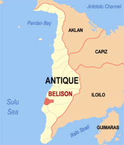 Location within Antique province | |
.svg.png) Belison Location within the Philippines | |
| Coordinates: 10°50′N 121°58′E / 10.83°N 121.97°ECoordinates: 10°50′N 121°58′E / 10.83°N 121.97°E | |
| Country | Philippines |
| Region | Western Visayas (Region VI) |
| Province | Antique |
| District | Lone district |
| Founded | March 10, 1961 |
| Barangays | 11 (see Barangays) |
| Government [1] | |
| • Type | Sangguniang Bayan |
| • Mayor | Darell B. Dela Flor |
| • Vice Mayor | Reynaldo Jacaba |
| Area[2] | |
| • Total | 19.78 km2 (7.64 sq mi) |
| Population (2015 census)[3] | |
| • Total | 13,539 |
| • Density | 680/km2 (1,800/sq mi) |
| • Voter (2016)[4] | 8,564 |
| Time zone | PST (UTC+8) |
| ZIP code | 5701 |
| IDD : area code | +63 (0)36 |
| Income class | 5th class |
| PSGC | 060603000 |
| Feast Day | February 2 |
| Website |
elgu |
Belison, officially the Municipality of Belison (Karay-a: Banwa kang Belison; Hiligaynon: Banwa sang Belison; Filipino: Bayan ng Belison), is a municipality in the province of Antique in the Western Visayas (Region VI) of the Philippines. The population was 13,539 at the 2015 census.[3] In the 2016 election, it had 8,564 registered voters.[4]
Belison is the smallest (in area and population)[5] and the youngest municipality in the province of Antique.[6]
History
Belison was merely a barangay in the larger municipality of Patnongon, adjacent to the north. Belison barangay leaders and Manila-based Belisongnons (Belisong natives) mapped out a petition requesting the national government to make Belison an independent town. The petition was brought to Malacañan Palace on March 10, 1961, and through Presidential Executive Order No. 421 signed by President Carlos P. Garcia,[6] Belison was declared a municipality - the smallest and the youngest in the Province of Antique.
During World War II, Japanese war submarines and other marine craft found the shores of Belison easy entry points to Panay, and invaded the Western Visayas in that location. People still tell of the fear created by these foreign intruders, and also of the bravery of those who decided to resist, creating rebel strongholds in the mountainous areas above the municipality.
When the Japanese air raids would bomb Belison and the nearby communities, families from all around fled to Guinobatan Cave, high in the hills of barangay Buenavista. And when the American forces came, they too used the smooth sea landing in Belison, bringing relief food supplies to Belisongnons, and troops to attack the Japanese occupying forces. They often used local homes in the area to hide in while planning their strategies for assault against the enemy, and enlisted the help of brave men and women to carry out their plans.
Geography
Belison is located at 10°50′N 121°58′E / 10.83°N 121.97°E.
According to the Philippine Statistics Authority, the municipality has a land area of 19.78 square kilometres (7.64 sq mi)[2] constituting 0.72% of the 2,729.17-square-kilometre- (1,053.74 sq mi) total area of Antique.
The municipality is bounded on the east and south-west by Sibalom, south by San Jose de Buenavista, north by Patnongon, and west by the Cuyo East Pass.
Barangays
Belison is politically subdivided into 11 barangays,[5] each with a duly constituted government unit known as the barangay council headed by the barangay captain. The Poblacion, seat of the municipal government, is an urban barangay. The other 10 are considered rural.
| PSGC | Barangay | Population | ±% p.a. | ||
|---|---|---|---|---|---|
| 2015[3] | 2010[7] | ||||
| 060603001 | Borocboroc | 9.3% | 1,261 | 1,173 | +1.39% |
| 060603002 | Buenavista | 3.7% | 504 | 449 | +2.22% |
| 060603003 | Concepcion | 9.3% | 1,263 | 1,165 | +1.55% |
| 060603004 | Delima | 5.8% | 790 | 751 | +0.97% |
| 060603005 | Ipil | 5.5% | 744 | 689 | +1.47% |
| 060603006 | Maradiona | 11.9% | 1,613 | 1,539 | +0.90% |
| 060603007 | Mojon | 3.4% | 461 | 410 | +2.26% |
| 060603008 | Poblacion | 33.3% | 4,503 | 4,479 | +0.10% |
| 060603009 | Rombang | 7.5% | 1,016 | 834 | +3.83% |
| 060603010 | Salvacion | 3.7% | 497 | 464 | +1.32% |
| 060603011 | Sinaja | 6.6% | 887 | 854 | +0.72% |
| Total | 13,539 | 12,807 | +1.06% | ||
Demographics
| Population census of Belison | |||||||||||||||||||||||||
|---|---|---|---|---|---|---|---|---|---|---|---|---|---|---|---|---|---|---|---|---|---|---|---|---|---|
|
| ||||||||||||||||||||||||
| Source: PSA[3][7][8] | |||||||||||||||||||||||||
In the 2015 census, Belison had a population of 13,539.[3] The population density was 680 inhabitants per square kilometre (1,800/sq mi).
In the 2016 election, it had 8,564 registered voters.[4]
Economy
Agriculture continues to be the heartbeat of the town. More than half of its land is riceland, while the rest are planted to corn, coconut, sugar cane and other production like vegetables and peanuts.
Municipal seal
The Belison municipal seal was created to commemorate the agricultural heritage of the town, in order to preserve the legacy of the original settlers in the region. It depicts three mainstay agricultural activities:
- The top image represents fishing and the bounties of the neighboring sea.
- The lower left portion is the harvesting of sugar cane, its processing muscovado sugar.
- The lower right depicts tilling of the lowlands for the planting of rice and other grains and vegetables.
Surrounding the great triangle are eleven stars – one representing each barangay in the town. The largest star at the bottom is for the Poblacion. Their strength lies in their connectivity to one another, and in their closeness to the traditions of the past.
Churches
Nine (9) of the leading Christian religious dominations in the Philippines established their presence in the town. Most Belisongnons (people of Belison) are of Aglipayan ancestry.
- Aglipayan or the members of the Iglesia Filipina Independiente (Parish of Our Lady of Purity & Candles) have a church along Delima Street.
- Roman Catholics, there is the Lady of Candles Parish located along Oliverio Street.
- Seventh-day Adventist Church located along Placer Street.
- Iglesia ni Cristo has two locales, one in Candelaria Street, Poblacion and another in National Road, Brgy. Rombang.
- Assembly of God located along Candelaria Street.
- Belison Baptist Church located along Rizal Street.
- Born Again Church located in Brgy. Maradiona.
- United Pentecostal Church is located along National Road (Brgy. Poblacion).
- Victory Christian Church is located along Bajalan-Lancara Street.
References
- ↑ "Municipality". Quezon City, Philippines: Department of the Interior and Local Government. Retrieved 31 May 2013.
- 1 2 "Province: Antique". PSGC Interactive. Makati City, Philippines: Philippine Statistics Authority. Retrieved 30 October 2016.
- 1 2 3 4 5 "Region VI (WESTERN VISAYAS)". Census of Population (2015): Total Population by Province, City, Municipality and Barangay (Report). PSA. Retrieved 20 June 2016.
- 1 2 3 "2016 National and Local Elections Statistics". Commission on Elections. 2016.
- 1 2 "Municipal: Belison, Antique". PSA. Philippines: National Statistical Coordination Board. Retrieved 8 January 2016.
- 1 2 "Executive Order No. 421, s. 1961: Creating the Municipality of Belison in the Province of Antique". Gov.ph. Manila: Official Gazette of the Republic of the Philippines. March 10, 1961. Retrieved 23 August 2016.
- 1 2 "Region VI (WESTERN VISAYAS)". Census of Population and Housing (2010): Total Population by Province, City, Municipality and Barangay (Report). NSO. Retrieved 29 June 2016.
- ↑ "Region VI (WESTERN VISAYAS)". Census of Population (1995, 2000 and 2007): Total Population by Province, City and Municipality (Report). NSO. Archived from the original on 24 June 2011.
 |
Patnongon | | ||
| Sulu Sea | |
San Remigio | ||
| ||||
| | ||||
| San Jose | Sibalom |
San Jose de Buenavista (capital) | |
| Municipalities | |