Hanford Reach National Monument
| Hanford Reach National Monument | |
|---|---|
|
IUCN category VI (protected area with sustainable use of natural resources) | |
 | |
 | |
| Location | Benton / Grant / Franklin / Adams counties, Washington, USA |
| Nearest city | Richland, WA |
| Coordinates | 46°35′00″N 119°31′00″W / 46.58333°N 119.51667°WCoordinates: 46°35′00″N 119°31′00″W / 46.58333°N 119.51667°W |
| Area | 194,451 acres (78,692 ha) [1] |
| Created | June 8, 2000 |
| Governing body | U.S. Fish and Wildlife Service |
| Website | Hanford Reach National Monument |
The Hanford Reach National Monument is a national monument in the U.S. State of Washington. It was created in 2000, mostly from the former security buffer surrounding the Hanford Nuclear Reservation (Hanford Site). The area has been untouched by development or agriculture since 1943.
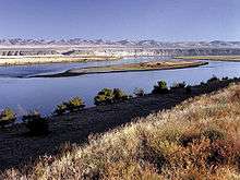
The monument is named after the Hanford Reach, the last non-tidal, free-flowing section of the Columbia River in the United States, and is one of only two National Monuments administered by the U. S. Fish and Wildlife Service. President Bill Clinton established the monument by presidential decree in 2000.
Ancestors of the Wanapum People, Yakama Nation, Confederated Tribes of the Colville, Confederated Tribes of the Umatilla Reservation and the Nez Perce used the land for hunting and resource collecting.
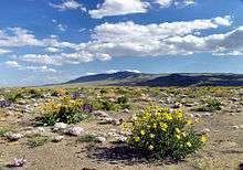
Geographically, the area is part of the Columbia River Plateau, formed by basalt lava flows and water erosion. The shrub-steppe landscape is harsh and dry, receiving between 5 and 10 inches (250 mm) of rain per year. The sagebrush-bitterbrush-bunchgrass lands are home to a wide variety of plants and animals, and the Hanford Reach provides one of the Northwest's best salmon spawning grounds. Forty-eight rare, threatened, or endangered animal species have found refuge on the monument, as well as several insect species found nowhere else in the world.[2]
Fish and Wildlife
There are two main habitats in the Hanford Reach National Monument: desert and river.
Islands, riffles, gravel bars, oxbow ponds and backwater sloughs provide support to forty-three species of fish. Large numbers of fall Chinook salmon spawn in the Hanford reach. Federally threatened species such as the Upper Columbia River Spring Chinook, the Middle Columbia River Steelhead and the Upper Columbia River Steelhead use the reach for migration purposes.[3]
The refuge is famous for the elk located on the Arid Lands Ecology Area. Herd numbers vary by time of year with 150 seen during the spring/summer and 350 to 375 during the fall. The elk population reaches its peak in the winter with an average of 670. Archaeologists believed the elk had been in the region for the last 10,000 years. During the mid-19th century, first hand accounts mentioned the disappearance of the species. Rocky Mountain elk were reintroduced into the region during the 1930s.[4]
The dry, desert region is home to forty-two mammal species. Mice are the most abundant and include the deer mouse, western harvest mouse, northern grasshopper mouse. Mammals that inhabit this refuge include coyotes, skunks, beavers, mule deer, bobcats, river otters, minks, cougars and badgers.
Hanford Nuclear Reservation
Hanford Reach is home to nine nuclear reactors of which B Reactor is the most famous; constructed in 13 months during World War II, it was the world’s first full scale reactor. Plutonium from the reactor was used in the first nuclear explosion at the Alamogordo Bombing and Gunnery Range in New Mexico (July 16, 1945) and in the Fat Man atomic bomb dropped on Nagasaki, Japan (August 9, 1945). The reactor’s significance has led to many distinctions including a place on the National Historic Mechanical Engineering Landmark, National Register of Historic Places, Nuclear Historic Landmark, National Civil Engineering Landmark and National Historic Landmark.
Access

The monument is open from two hours before sunrise to two hours after sunset; some areas are open to the public and others are not:
- Fitzner-Eberhardt Arid Lands Ecology Reserve - access permitted for ecological research, closed to the public.
- Columbia River Corridor - shore and open water is generally open to the public.
- McGee Ranch and Riverlands - public day use.
- Saddle Mountain National Wildlife Refuge, located at 46°41′18″N 119°37′39″W / 46.68833°N 119.62750°W - access permitted for ecological research, closed to the public.
- Vernita Bridge - open to the public.
- Wahluke Slope - open to the public.
The Rattlesnake Mountain Public Access Act (H
References
- ↑ "Annual Report of Lands as of September 30, 2009" (PDF). United States Fish and Wildlife Service.
- ↑ "US Fish and Wildlife Hanford Reach National Monument". August 18, 2009. Retrieved August 18, 2009.
- ↑ "U.S. Fish & Wildlife Service: Hanford Reach Wildlife & Habitat". fws.gov. U.S. Fish and Wildlife Service. Retrieved 2016-07-23.
- ↑ "US Fish and Wildlife Hanford Reach National Monument Elk". August 18, 2009. Retrieved August 18, 2009.
- ↑ "CBO - H.R. 1157". Congressional Budget Office. Retrieved 12 June 2013.
- ↑ Kasperowicz, Pete (11 June 2013). "To the top of Rattlesnake Mountain". The Hill. Retrieved 13 June 2013.
- White House Press Release
- Washington State precipitation map
- Pacific Northwest National Laboratory resource cards
External links
| Wikimedia Commons has media related to Hanford Reach National Monument. |
| Wikisource has original text related to this article: |
| Topics | |
|---|---|
| Lists by states |
|
| Lists by insular areas | |
| Lists by associated states | |
| Other areas | |
| |