Upper Missouri River Breaks National Monument
| Upper Missouri River Breaks National Monument | |
|---|---|
|
IUCN category V (protected landscape/seascape) | |
|
The breaks of the Upper Missouri River National Monument | |
 | |
| Location | Chouteau, Fergus, Blaine, and Phillips counties, Montana, USA |
| Nearest city | Great Falls, MT |
| Coordinates | 47°47′0″N 109°1′17″W / 47.78333°N 109.02139°WCoordinates: 47°47′0″N 109°1′17″W / 47.78333°N 109.02139°W |
| Area | 495,502 acres (200,523 ha)[1] |
| Established | January 17, 2001 |
| Visitors | 63,512 (in 2002) |
| Governing body | U.S. Bureau of Land Management |
| Website | Upper Missouri River Breaks National Monument |
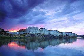
The Upper Missouri River Breaks National Monument is a national monument protecting the Missouri Breaks of central Montana, United States. It is managed by the Bureau of Land Management. Called "The Breaks" by locals, it is a series of badland areas characterized by rock outcroppings, steep bluffs and grassy plains. Created by Proclamation by President William J. Clinton on January 17, 2001, it encompasses 495,502 acres (200,523 ha),[1] most of which were already managed by the U.S. government. The adjacent Missouri River was designated a Wild and Scenic River in 1976 and forms a western boundary while the Charles M. Russell National Wildlife Refuge is to the east. The Breaks country was a model for many of the paintings done by painter Charles M. Russell.
History
French trappers found the area in the late 18th century peopled by Native American tribes such as the Blackfoot, Northern Cheyenne, Sioux, Assiniboine, Gros Ventre (Atsina), Crow, Plains Cree and Plains Ojibwa. (The Crow name is Xuáhcheesh Annáppiio, "Where the Crow warrior Skunk was killed."[2])
The Lewis and Clark Expedition passed through the Breaks in 1805 and were the first to document the region through notes and drawings, and their sighting and documentation of bighorn sheep in the Breaks region was the first time this species was recorded in North America by white explorers. Much of the Breaks region has remained as it was when Lewis and Clark's party first saw it. "The confluence of the Judith and Missouri Rivers was the setting for important peace councils in 1846 and 1855. In 1877, the Nez Perce crossed the Missouri and entered the Breaks country in their attempt to escape to Canada. The Cow Island Skirmish occurred in the Breaks and was the last encounter prior to the Nez Perce's surrender to the U.S. Army at the Battle of Bear Paw just north of the monument."[3][4]

Management and conservation
A full management plan is still under development due to various private inholdings and lease agreements between private citizens and the federal government. While conservationists would like to see some of the Breaks monument lands become designated as Wilderness, local ranchers and farmers, under long standing lease agreements with the federal government who graze upwards of 10,000 head of cattle annually within the new monument, are concerned that the monument status may adversely affect their livelihood and the economies of local towns. Under the proposed management plan from the Department of the Interior, although the resources of the monument will be given better protection, "currently permitted livestock grazing, hunting, fishing, and similar activities will generally not be affected, nor will private property (approximately 81,911 acres [331 km2]) and state land (approximately 38,722 acres [157 km2]) within the boundary of the proposed monument, as well as other valid existing rights."[5]
In 2013, the U.S. Court of Appeals ruled that the Bureau of Land Management's management plan violated historic site laws with their practices.[6] The National Trust for Historic Preservation cited the site as one of ten historic sites saved in 2013.[6]
The Breaks is home to at least 60 mammal species and hundreds of bird species. Willows and shrubs are found along the Missouri River banks while sagebrush and short grass prairie are dominant elsewhere.
See also
References
- 1 2 "National Monument detail table as of April 2012" (PDF). Bureau of Land Management. Retrieved 2012-12-27.
- ↑ "Little Big Horn College Library". Retrieved 2012-06-05.
- ↑ Proclamation 7398-Establishment of the Upper Missouri River Breaks National Monument.(Transcript) - Weekly Compilation of Presidential Documents | HighBeam Research (subscription required)
- ↑ "Proclamation 7398 - Establishment of the Upper Missouri River Breaks National Monument". The American Presidency Project. University of California, Santa Barbara. January 17, 2001. Retrieved May 18, 2016.
- ↑ "Proposed Upper Missouri River Breaks National Monument". United States Department of the Interior. Archived from the original on 2005-02-17.
- 1 2 staff (January 5, 2014). "A look at 10 historic sites save, 10 lost in 2013". Associated Press as reported by the Post Crescent. p. F3.
External links
| Wikivoyage has a travel guide for Upper Missouri River Breaks National Monument. |
| Wikimedia Commons has media related to Upper Missouri River Breaks National Monument. |
- "Welcome to the Upper Missouri River Breaks National Monument". U.S. Bureau of Land Management. Retrieved 2006-08-13.
- "Upper Missouri Breaks National Monument". The Wilderness Society. Archived from the original on 2006-07-10. Retrieved 2006-08-13.
- "Upper Missouri River Breaks National Monument". Montana Wildlife Federation. Retrieved 2011-08-11.
- Map Bureau of Land Management
| Lists |  | |
|---|---|---|
| Geography | ||
| Native American tribes | ||
| History | ||
| Engineering | ||
| Parks and preserves | ||